
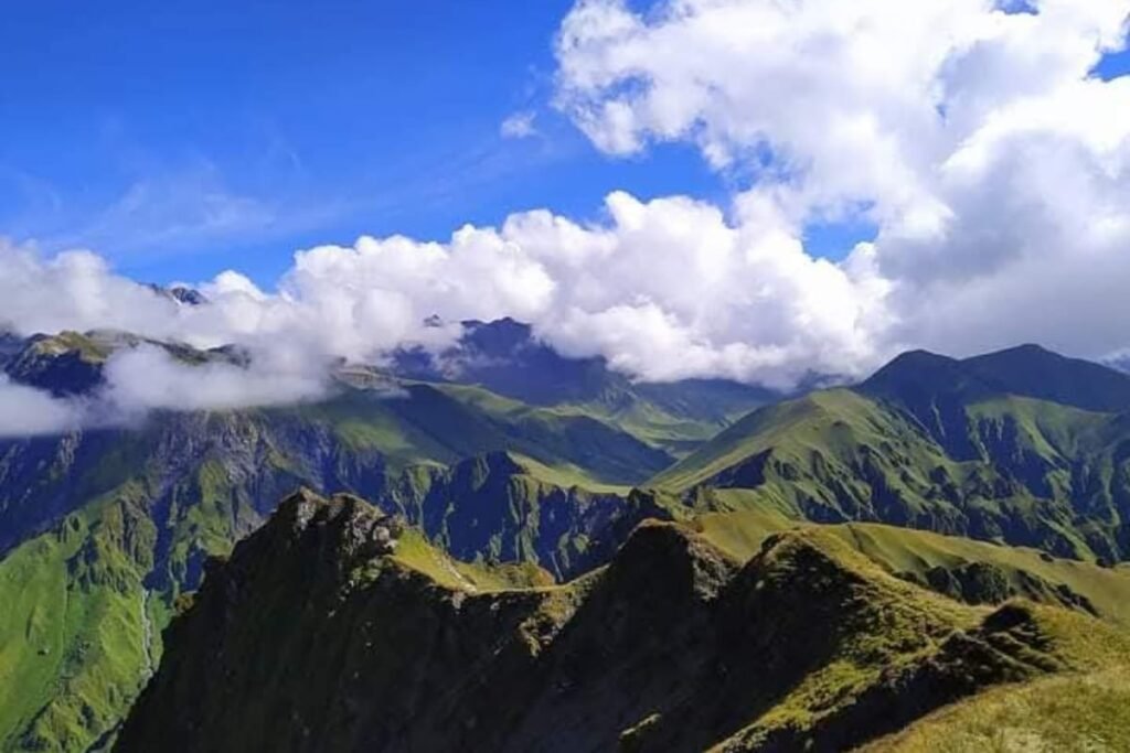
Gidara Bugyal is one of the largest and most pristine high-altitude alpine meadows in Uttarkashi district, Uttarakhand, reached primarily via routes from the Bhangeli area, with Raithal and Gangnani also referenced as access points in various accounts. Gidara Bugyal Uttarkashi Bhangeli sits at a genuinely high altitude — reported at approximately 3,900–4,240 meters (sources vary on the exact figure, with Gidara Top specifically noted at around 4,236–4,240 meters) — and is described by those familiar with the region as significantly larger than the better-known Dayara Bugyal, with vast rolling meadows, near-zero footsteps from other travelers, and genuinely uninterrupted views of the Gangotri, Jogin, Srikanth, and Draupadi Ka Danda peaks on a clear day.
This guide covers the Bhangeli route, trek difficulty, distance, altitude, camping, best time to visit, and more than 35 answered questions — everything needed to plan a trip to one of Uttarkashi’s most remote and rewarding alpine meadows.
A note on trek statistics: Available sources give somewhat varying figures for Gidara Bugyal’s distance (approximately 31–33 km total) and altitude (roughly 3,900–4,240 meters depending on which point is referenced) — this guide presents the range rather than a single fixed number, and recommends confirming current figures with your guide before booking.
What Is Gidara Bugyal?
Gidara Bugyal is a vast, high-altitude alpine meadow in Uttarkashi district, Uttarakhand, reached via a multi-day trek from the Bhangeli area, notable for being significantly larger and less commercialized than Dayara Bugyal and other well-known Uttarakhand meadows.
The meadow spreads across a valley floor bounded by rolling grassy hills that enclose it almost like an amphitheatre, with clear running streams marking the only real breaks in the expanse of grass. Reaching the far end of the meadow can take the better part of a day given its scale — a genuinely different experience from the more compact, road-adjacent bugyals elsewhere in the district. Local trek staff familiar with the region describe it in Hindi terms that translate roughly to “if you haven’t seen Gidara, you haven’t seen much of anything” — a strong claim, but one consistently echoed by those who’ve compared it directly to the district’s other meadows.

Where Is Gidara Bugyal Located?
Gidara Bugyal is located in the Garhwal Himalayas, in Uttarkashi district of Uttarakhand, near Dayara Bugyal but at a higher altitude, with Bhangeli serving as a primary access route alongside Raithal and Gangnani mentioned in various trekking accounts.
| Location | Relationship |
|---|---|
| Uttarkashi | Main regional town |
| Bhangeli | Important access village/route to Gidara Bugyal |
| Dayara Bugyal | Nearby, lower-altitude alpine meadow |
| Raithal | Alternative access route referenced in some accounts |
| Gangnani | Alternative access route referenced in some accounts |
| Bhatwari | Regional travel point |
| Harsil | Wider Uttarkashi trekking circuit |
Given some variation in how different sources describe the exact access route, confirming your specific starting point and current trail conditions with a local guide is genuinely important for this trek.
Why Is Gidara Bugyal Famous?
Gidara Bugyal’s core reputation rests on scale and solitude — it’s reported to be roughly twice the size of Dayara Bugyal, Ali Bugyal, and Bedni Bugyal, and its relative remoteness means trekkers encounter far fewer other people on the trail than at more established meadow destinations. The trek moves through undulating meadows and grassland, diverse flora and fauna, and genuinely scenic campsites, culminating in a high-altitude ridge walk to Gidara Top — reported at approximately 4,236–4,240 meters — where clear days deliver uninterrupted views of the Gangotri group, Jogin, Srikanth, and Draupadi Ka Danda (DKD) peaks.
Ready to trek one of Uttarkashi’s largest and least-crowded alpine meadows? Kashi of North organizes guided Gidara Bugyal Trek packages from Bhangeli — WhatsApp +91 7253079221.
Gidara Bugyal and Bhangeli
Bhangeli functions as one of the key access points for the Gidara Bugyal Trek, serving as the practical starting village where trekkers arrange final logistics, accommodation, and guide support before beginning the multi-day route into the meadow.
Given the trek’s genuinely remote and less-commercialized character compared to Dayara Bugyal, arranging guides, camping equipment, and route confirmation before arriving in Bhangeli is a meaningful part of preparation — this isn’t a route where you can expect readily available walk-up infrastructure at the trailhead itself. Local accommodation options in and around Bhangeli tend to be modest, consistent with the village’s role as a trekking access point rather than a developed tourist base.
Want your Bhangeli logistics — accommodation, guide, and transport — fully arranged before you arrive? Kashi of North handles the complete setup — call or WhatsApp +91 7253079221.
Gidara Bugyal Trek Overview
| Trek Feature | Details |
|---|---|
| Trek name | Gidara Bugyal Trek |
| Region | Uttarkashi, Uttarakhand |
| Route | Via Bhangeli (also referenced: Raithal, Gangnani) |
| Trek type | High-altitude alpine meadow trek |
| Difficulty | Moderate to Difficult |
| Trek distance | Approximately 31–33 km total |
| Maximum altitude | Approximately 3,900–4,240 m (Gidara Top) |
| Trail type | Forest, meadow, ridge, and mountain terrain |
| Camping | Required — multi-day route |
| Guide | Strongly recommended |
| Best season | May–June (pre-monsoon) and September–October (post-monsoon) |
| Permit | Verify current forest/local regulations |
Gidara Bugyal Trek Route
The Gidara Bugyal Trek moves through forest approach trails, opens into undulating meadowland, and culminates in a high-altitude ridge walk to Gidara Top, with the full meadow traverse alone reported to take nearly two days given its scale.
General Route Stages
- Arrival at Bhangeli — road journey, accommodation, trek briefing, equipment check
- Forest approach — trail through pine, oak, and mixed forest, gradual elevation gain
- Campsite (forest/transition zone) — often referenced as Ricoda, surrounded by dense pine, oak, and rhododendron forest
- Meadow entry — the trail opens into Gidara Bugyal’s rolling grassland
- Meadow traverse — crossing the extensive meadow itself, which can take the better part of a day or more given its size
- Ridge walk to Gidara Top (~4,236–4,240 m) — the trek’s highlight, with clear-day views of Gangotri, Jogin, Srikanth, and Draupadi Ka Danda
- Return route — retracing or an alternative descent back toward Bhangeli
Exact stage-by-stage distances and durations vary by source and current trail conditions — treat this as the general shape of the trek rather than a fixed schedule, and confirm specifics with your guide.
Day-wise Itinerary
Note: The itinerary below reflects a general framework; actual day-wise breakdowns depend on route, weather, and operator planning.
| Day | Activity |
|---|---|
| Day 1 | Uttarkashi to Bhangeli — road journey, arrival, accommodation, trek briefing, weather assessment |
| Day 2 | Bhangeli to forest campsite (e.g., Ricoda) — forest trail, elevation gain, water sources, camping |
| Day 3 | Campsite to Gidara Bugyal meadow — meadow approach, landscape, mountain views, camping |
| Day 4 | Explore Gidara Bugyal — meadow traverse, ridge walk to Gidara Top, photography, sunrise/sunset |
| Day 5 | Return toward Bhangeli — descent, overnight camp if required |
| Day 6 | Bhangeli to Uttarkashi — departure |
Want this itinerary confirmed against current trail and campsite conditions? Kashi of North can arrange a guided trek with an experienced local leader — call or WhatsApp +91 7253079221.
Gidara Bugyal Trek Distance
Total trek distance is reported at approximately 31 to 33 km, with the meadow traverse alone taking nearly two days given its considerable scale — genuinely more extensive than most other Uttarkashi bugyal treks.
Daily walking distances and elevation gain vary by exact route and pace — the forest approach sections involve steady, moderate climbing, while the meadow traverse itself, though less steep, covers real distance across open terrain. The final ridge walk to Gidara Top involves additional elevation gain over exposed, high-altitude ground.
Gidara Bugyal Altitude
Gidara Bugyal is reported at a peak altitude of approximately 3,900 to 4,240 meters, with Gidara Top — the trek’s highest point and signature viewpoint — specifically cited at around 4,236–4,240 meters (roughly 13,900 feet).
This altitude is genuinely higher than Dayara Bugyal, and acclimatization matters accordingly — the trek’s multi-day structure through forest and lower meadow before the final ridge push to Gidara Top provides a natural staged ascent, but trekkers should still take altitude seriously, hydrate well, and watch for symptoms of altitude sickness as elevation increases.
Trek Difficulty
Gidara Bugyal is rated Moderate to Difficult — while much of the meadow walking itself is comparatively gentle, the trail includes steep and treacherous sections, particularly on the approach and ridge portions, and genuinely requires good cardiovascular endurance.
Some accounts describe the trek as accessible to both beginners and experienced trekkers given the meadow’s relatively gentle terrain once reached, while others emphasize that novices should be in good physical shape given steep sections along the way. This guide reconciles those views by recommending that first-time trekkers approach Gidara Bugyal only with a guide and realistic fitness preparation — this is a genuinely more demanding trek than the district’s easier bugyal routes, given both its distance and altitude.
Who Should Do the Gidara Bugyal Trek?
Beginners: Possible with strong guide support and honest fitness preparation, but this isn’t the gentlest introduction to Himalayan trekking given the distance and altitude involved.
Experienced Trekkers: A genuinely rewarding route given the scale, solitude, and viewpoint payoff at Gidara Top.
Solo Travelers: Feasible with a local guide, given the route’s remote, less-developed character.
Families: Better suited to families with older children and established hiking fitness rather than young children or complete beginners.
Couples: A peaceful, uncrowded option for couples seeking genuine solitude rather than a well-trafficked meadow.
Photographers: Exceptional — the meadow’s scale, the ridge walk views, and minimal other-trekker presence make this a strong photography destination.
Best Time to Visit
May–June (pre-monsoon) and September–October (post-monsoon) are the recommended windows for the Gidara Bugyal Trek, offering the best combination of trail accessibility and mountain visibility.
- Spring: Fresh greenery returning, though snow patches may persist at higher elevations.
- Summer (May–June): Comfortable trekking temperatures and lush meadow conditions — one of the two best windows.
- Monsoon (July–August): Lush vegetation but genuinely slippery trails and landslide/road risk — generally best avoided.
- Autumn (September–October): Clear mountain views and stable trekking conditions — the other recommended window.
- Winter (December–February): Snow and extreme cold create real accessibility issues — requires specialized winter planning and experienced guidance.
Month-by-Month Guide
| Month | Weather | Trail | Snow | Recommendation |
|---|---|---|---|---|
| March | Cold | Variable | Possible | Weather dependent |
| April | Pleasant/cold | Improving | Possible | Good |
| May | Pleasant | Good | Limited at lower levels | Excellent |
| June | Pleasant | Good | Variable | Excellent |
| July | Wet | Slippery | No | Caution |
| August | Wet | Difficult in rain | No | Generally avoid unless conditions confirmed suitable |
| September | Improving | Good | Limited | Excellent |
| October | Cold/clear | Good | Possible higher up | Excellent |
| November | Cold | Variable | Possible | Experienced trekkers |
| December–February | Very cold | Snow dependent | Likely | Specialized winter planning only |
Gidara Bugyal in Winter
Winter transforms Gidara Bugyal into a genuinely demanding environment — snow cover, extreme cold, reduced trail visibility, and real navigation difficulty across the exposed meadow and ridge sections. Cold-weather camping equipment, appropriate winter gear, and an experienced guide are all essential for anyone attempting this trek in winter. Snowfall isn’t guaranteed on any specific date, but the general risk of significant snow accumulation from December through February should be assumed for planning purposes rather than checked casually.
Landscape, Mountain Views, and Wildlife
The trek moves through pine, oak, and rhododendron forest before opening into undulating alpine meadow and grassland, framed by rolling hills that enclose the valley floor almost like an amphitheatre, with clear running streams cutting through the grass. From Gidara Top, clear-day views take in the Gangotri group, Jogin, Srikanth, and Draupadi Ka Danda (DKD) — though actual visibility depends on weather, exact viewpoint, and season, and shouldn’t be assumed guaranteed on any given day.
Flora along the route includes oak, rhododendron, deodar, and Himalayan birch at forest elevations, transitioning to alpine grasses and seasonal wildflowers in the meadow itself. Wildlife potentially present in the region includes Himalayan monal, Himalayan tahr, musk deer, and Himalayan fox, though sightings of any of these are genuinely unpredictable and shouldn’t be treated as an expected part of the trek.
Shepherds and Pastoral Culture
Gidara Bugyal’s extensive grassland has traditionally served as seasonal grazing land, and trekkers may encounter shepherd camps and grazing livestock along the route, particularly in summer. These are working pastoral communities using land they’ve relied on for generations — treat any shepherd camps you encounter with genuine respect, avoid disturbing livestock, and approach local knowledge of mountain routes as a valuable resource rather than simply local color.
Camping at Gidara Bugyal
Tent camping is required for this multi-day trek, with Ricoda referenced as a notable forest campsite surrounded by dense pine, oak, and rhododendron forest along the route. Water is generally available from streams, though always purify before drinking, and availability should be confirmed with your guide given seasonal variation. Follow Leave No Trace principles throughout — use designated camping areas where they exist, avoid unnecessary fires, and manage waste responsibly given the complete absence of infrastructure on this remote route.
Want your camping equipment and meals fully organized for the trek? Kashi of North handles the complete camping logistics as part of its Gidara Bugyal packages — WhatsApp +91 7253079221.
Food and Water
Meals on a guided trek are typically camp-prepared, with hearty, high-calorie food suited to multi-day high-altitude trekking. Carry high-energy trail snacks — dry fruits, energy bars, chocolate — and electrolytes or ORS for hydration management, particularly given the trek’s genuine distance and elevation gain. Water sources exist along the route via streams and springs, but should always be purified, and current availability should be confirmed with your guide rather than assumed year-round.
Packing List
| Category | Items |
|---|---|
| Clothing | Base layer, fleece, insulated jacket, waterproof jacket, trek pants, thermal wear, woolen socks, gloves, cap, sun hat |
| Footwear | Good trekking shoes, camp footwear, gaiters for snow/mud sections |
| Trek equipment | Backpack, headlamp, trekking poles, sleeping bag (rated appropriately for altitude), water bottles, sunglasses, sunscreen, power bank |
| Medical | Personal medicines, basic first aid, blister care, ORS/electrolytes, prescription medications |
| Documents | Government ID, any required permits, emergency contact information |
Fitness Preparation and Acclimatization
Fitness preparation: Given the trek’s genuine distance and altitude, a structured preparation period matters. A practical 4-week framework: build cardiovascular base through regular walking, jogging, or cycling in weeks 1–2; add stair climbing and loaded backpack walks in weeks 2–3; incorporate longer hikes with elevation gain in week 3–4; and taper slightly in the final days before departure while staying active.
Acclimatization: Ascend gradually, hydrate consistently, prioritize sleep and rest at each stage, and stay alert to altitude-related symptoms — headache, nausea, dizziness, or unusual fatigue. Descend if symptoms worsen rather than pushing through. This guide doesn’t provide medical diagnosis — consult a doctor beforehand if you have relevant health concerns, particularly given the altitude involved.
Safety Tips
Weather can change rapidly at this altitude — rain, snow, and fog can all affect trail conditions with little warning. Slippery terrain is a genuine concern on both forest and ridge sections, particularly after rain. River and stream crossings require care. Altitude effects should be taken seriously given the trek’s genuine elevation. Navigation on the less-developed sections of this route benefits significantly from local guide knowledge, and mobile communication should not be relied upon given the route’s remoteness. Inform someone of your itinerary before departing, and build buffer days into your plan given the trek’s weather-sensitivity.
How to Reach Bhangeli
Bhangeli is reached via Dehradun, Rishikesh, and Uttarkashi by road, with the final stretch requiring local transport into the trekking access area.
From Uttarkashi
Local road connection — confirm current route and travel time with a driver or guide familiar with the Bhangeli approach.
From Dehradun
General route: Dehradun → Mussoorie/Suwakholi → Uttarkashi → Bhangeli.
From Rishikesh
Via the Rishikesh–Uttarkashi highway, continuing on to Bhangeli.
From Haridwar
Via Rishikesh, following the same onward route.
From Delhi
Delhi → Dehradun → Uttarkashi → Bhangeli, typically requiring an overnight stop given total travel time.
By Air
The nearest airport is Jolly Grant Airport, Dehradun, followed by road travel via Uttarkashi.
By Train
The nearest railway stations are Dehradun and Haridwar, both requiring onward road travel.
Self-Drive
Mountain driving conditions apply throughout — plan for fuel in Uttarkashi before the final approach, avoid night driving, and take extra care during monsoon given landslide risk.
Prefer not to arrange the full Dehradun–Bhangeli route yourself? Kashi of North provides private taxi service for the complete journey — WhatsApp +91 7253079221.
Distance Chart
| Origin | Approximate Distance | Notes |
|---|---|---|
| Delhi | Verify current route | Via Dehradun/Rishikesh |
| Dehradun | Verify current route | Via Rishikesh/Uttarkashi |
| Rishikesh | Verify current route | Via Uttarkashi |
| Haridwar | Verify current route | Via Rishikesh/Uttarkashi |
| Uttarkashi | Verify current route | Direct road connection |
| Bhangeli | Trek starting area | Trek begins here |
Accommodation
Before the Trek
| Location | Type |
|---|---|
| Bhangeli | Basic homestays/guesthouses, verify availability |
| Uttarkashi | Wider range of hotels |
After the Trek
Returning to Bhangeli or Uttarkashi for recovery and onward travel is the standard approach — Uttarkashi offers more comfortable options if you want a proper rest before continuing your trip.
Want your Bhangeli or Uttarkashi accommodation confirmed before you travel? Kashi of North handles the full arrangement — call or WhatsApp +91 7253079221.
Trek Cost and Packages
| Package Type | Typical Components |
|---|---|
| Budget | Guide plus basic camping |
| Standard | Guide, meals, camping, and logistics |
| Premium | Private guide, better accommodation, and transport |
| Custom | Fully customized route and services |
Costs vary significantly based on group size, trek duration, guide arrangement, camping equipment, meals, transportation, accommodation, porter support, permits, and season. Given the trek’s remote, less-commercialized nature, confirm current, accurate pricing directly rather than relying on any fixed estimate.
Want an accurate cost breakdown for your group and dates? Kashi of North provides transparent Gidara Bugyal Trek pricing — call or WhatsApp +91 7253079221.
Gidara Bugyal vs Dayara Bugyal and Other Bugyals
| Feature | Gidara Bugyal | Dayara Bugyal |
|---|---|---|
| Popularity | Less commercialized | More established |
| Infrastructure | More limited | Better developed |
| Trekking character | More remote | More accessible |
| Meadow scale | Reported roughly twice the size | Extensive but smaller |
| Beginner suitability | Route and fitness dependent | Generally easier |
| Camping | Genuinely necessary | Common, well-supported |
| Trek planning | Guide strongly recommended | Easier for first-time trekkers |
Vs Harunta Bugyal and Kush Kalyan Bugyal: Both of these are shorter, easier meadow treks compared to Gidara Bugyal’s greater distance and altitude — Gidara is the more demanding, more remote option among Uttarkashi’s bugyal treks, better suited to trekkers specifically seeking solitude and a bigger physical undertaking.
Nearby Places
| Place | Notes |
|---|---|
| Bhangeli | Trek access village |
| Dayara Bugyal | Nearby, more established meadow trek |
| Uttarkashi | District headquarters |
| Bhatwari | Regional gateway town |
| Gangnani | Hot spring stop, also referenced as an alternative access route |
| Harsil | Apple orchard valley |
| Gangotri | Char Dham temple |
| Maneri | Reservoir and gorge landscape |
Want to combine Gidara Bugyal with a wider Uttarkashi trekking circuit? Kashi of North designs multi-destination itineraries — WhatsApp +91 7253079221.
Things to Do
- Explore the extensive alpine meadow landscape
- Complete the ridge walk to Gidara Top
- Photograph sunrise and sunset over the meadow
- Stargaze given minimal light pollution
- Camp at scenic sites like Ricoda
- Observe local flora and, potentially, wildlife
- Experience genuine local shepherd and pastoral culture
- Photograph the Gangotri, Jogin, Srikanth, and DKD peaks from Gidara Top
- Enjoy a genuinely uncrowded Himalayan trekking experience
Photography Guide
The meadow’s scale rewards wide-angle landscape photography, particularly from elevated points where the rolling grassland and enclosing hills can be captured together. The ridge walk to Gidara Top offers the trek’s signature mountain photography — Gangotri, Jogin, Srikanth, and Draupadi Ka Danda visible on clear days. Sunrise and sunset over the meadow are strong subjects given minimal obstruction. Night sky photography benefits genuinely from the route’s remoteness and corresponding lack of light pollution. Shepherd camps, where present, offer respectful cultural photography opportunities with appropriate permission.
Drone use: Restrictions may apply given this district’s proximity to sensitive border zones — verify current permissions before flying.
Responsible Trekking
Carry out all waste — this route has essentially no infrastructure to manage it. Avoid single-use plastic. Don’t damage alpine vegetation or pick wildflowers. Respect shepherd camps and grazing livestock you encounter along the way. Avoid disturbing wildlife. Use designated camping areas where they exist, and avoid unnecessary fires given the fragility of this ecosystem. Support the local economy directly — guides, homestays in Bhangeli, porters, and local food suppliers all benefit from responsible spending on this route.
Is Gidara Bugyal Suitable for Beginners?
Gidara Bugyal Trek suitability for beginners genuinely depends on the specific route taken and current conditions — while much of the meadow terrain itself is comparatively gentle, the trek’s overall distance, altitude, and some genuinely steep and treacherous sections mean first-time trekkers should approach this route with real fitness preparation and strong guide support rather than treating it as an easy introduction to Himalayan trekking.
Winter routes in particular require significantly more experience than the standard pre- or post-monsoon trek. If you’re a genuine beginner drawn to Gidara Bugyal specifically for its scale and solitude, going with an experienced local guide isn’t optional — it’s the responsible way to attempt this route.
Conclusion
Gidara Bugyal deserves genuine attention among Uttarkashi’s alpine trekking destinations — a meadow reported to be roughly twice the size of Dayara Bugyal, reached via a genuinely remote route from Bhangeli, delivering both real solitude and a signature ridge-walk payoff at Gidara Top with views across the Gangotri, Jogin, Srikanth, and Draupadi Ka Danda peaks. This is a more demanding undertaking than the district’s easier bugyal treks, and it rewards trekkers willing to prepare properly and go with experienced local guidance.
Planning your Gidara Bugyal Trek from Bhangeli? Kashi of North can help you plan the complete experience, including local accommodation, transportation, trekking guides, camping, and a customized Uttarkashi trekking itinerary.
📞 Call/WhatsApp: +91 7253079221 📧 Email: kashiofnorth@gmail.com 🌐 Website: kashiofnorth.com
Himalayan trekking involves changing weather, altitude, uneven terrain, and other natural risks. Route conditions can change quickly. Travelers should assess their fitness, carry appropriate equipment, follow local regulations, and use qualified guides where necessary.
Frequently Asked Questions
1. What is Gidara Bugyal? A vast, high-altitude alpine meadow in Uttarkashi district, Uttarakhand, reported to be roughly twice the size of Dayara Bugyal.
2. Where is Gidara Bugyal located? In the Garhwal Himalayas, Uttarkashi district, Uttarakhand, near but at a higher altitude than Dayara Bugyal.
3. Where is Gidara Bugyal in Uttarkashi? Accessed primarily via Bhangeli, with Raithal and Gangnani also referenced as alternative routes in various accounts.
4. Is Gidara Bugyal in Uttarakhand? Yes, in Uttarkashi district.
5. How do I reach Gidara Bugyal? Via road to Uttarkashi and then Bhangeli, followed by a multi-day trek into the meadow.
6. Is Bhangeli the starting point for Gidara Bugyal? Yes, it’s one of the primary access points, alongside Raithal and Gangnani in some accounts.
7. What is the Gidara Bugyal Trek route? Forest approach through pine, oak, and rhododendron, opening into extensive meadow, culminating in a ridge walk to Gidara Top.
8. How difficult is the Gidara Bugyal Trek? Moderate to Difficult — genuinely demanding given its distance, altitude, and some steep sections.
9. What is the Gidara Bugyal Trek distance? Approximately 31–33 km total.
10. What is the altitude of Gidara Bugyal? Approximately 3,900–4,240 meters, with Gidara Top specifically at roughly 4,236–4,240 meters.
11. How many days are required for Gidara Bugyal? Typically 5–6 days including travel to and from Bhangeli.
12. What is the best time to visit Gidara Bugyal? May–June and September–October.
13. Can I visit Gidara Bugyal in winter? Only with specialized winter preparation and an experienced guide, given snow and extreme cold.
14. Does it snow at Gidara Bugyal? Yes, particularly December through February — don’t assume a specific snowfall date without confirming conditions.
15. Is Gidara Bugyal suitable for beginners? Suitable only with strong guide support and genuine fitness preparation — not recommended as an easy introduction to trekking.
16. Is a guide required for Gidara Bugyal? Strongly recommended given the route’s remote, less-developed character.
17. What does a Gidara Bugyal Trek package include? Typically a guide, camping, meals, and transport, though exact inclusions vary by package — confirm with your operator.
18. What is the Gidara Bugyal Trek cost? Varies by group size, duration, and inclusions — contact Kashi of North for current, accurate pricing.
19. Where should I stay before the Gidara Bugyal Trek? Bhangeli (basic homestays) or Uttarkashi (wider hotel range).
20. Can I stay in Bhangeli Village? Yes, basic accommodation options exist — verify current availability before travel.
21. How far is Bhangeli from Uttarkashi? Distance varies by source — confirm current figures with a local driver or guide.
22. Is mobile network available on the trek? Limited to absent on much of the remote trail — don’t rely on connectivity.
23. Are there water sources on the route? Yes, streams and springs, though availability should be confirmed with your guide and water should always be purified.
24. Is camping available? Yes, required — this is a multi-day camping trek, with Ricoda referenced as a notable forest campsite.
25. What food is provided? Camp-prepared meals on a guided trek, alongside personal trail snacks and electrolytes you should carry.
26. What should I pack? Warm layered clothing, waterproof gear, trekking shoes, a sleeping bag rated for altitude, and a first-aid kit — see the full packing list above.
27. What shoes should I wear? Sturdy, broken-in trekking shoes with good grip, plus gaiters if snow or mud is expected.
28. Is Gidara Bugyal safe? Yes, with proper preparation, suitable weather timing, an experienced guide, correct equipment, and adequate fitness — remote Himalayan trekking always carries inherent risk.
29. Can families do the trek? Best suited to families with older children and established hiking fitness rather than young children.
30. Can solo travelers do the trek? Yes, with a local guide given the route’s remoteness.
31. What peaks can be seen from Gidara Bugyal? Gangotri group, Jogin, Srikanth, and Draupadi Ka Danda (DKD) on clear days from Gidara Top.
32. Is Gidara Bugyal better than Dayara Bugyal? Neither is universally better — Gidara offers greater scale and solitude but demands more fitness and altitude tolerance; Dayara is more accessible and beginner-friendly.
33. What other bugyals are near Uttarkashi? Dayara Bugyal, Harunta Bugyal, and Kush Kalyan Bugyal are all within the district’s wider trekking circuit.
34. Can I combine Gidara Bugyal with Harsil? Yes, as part of a broader Uttarkashi trekking and sightseeing circuit.
35. Can I combine Gidara Bugyal with Gangotri? Yes, both can be included in an extended Uttarkashi itinerary via Uttarkashi as the connecting point.
36. Can Kashi of North arrange a Gidara Bugyal Trek? Yes, including guides, camping, transport, and accommodation — reach out via WhatsApp at +91 7253079221.