

🥾 Trek
· Gangotri
Kedar Tal Trek – The Hardest Lake in Uttarkashi is the Most Beautiful
Difficult Trek
Kedar Tal Trek | Kedartal Trek Uttarkashi | Best treks in Gangotri | High altitude treks Uttarakhand
Some Lakes Demand to Be Earned
Not every high-altitude lake in the Himalaya is difficult to reach. Some sit at the end of gentle valleys, accessible to anyone who can walk for a day and carry a daypack. Kedar Tal is not one of those. The glacial lake at 4,750 metres in the upper Gangotri region of Uttarkashi sits behind one of the steepest, most unrelenting approach routes among all the Himalayan lake treks India offers — a route that climbs nearly 1,700 metres from its base village across terrain that offers no easy passages, no false flats, no extended respite from the gradient.
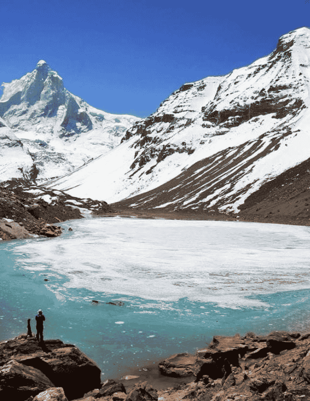
What the route offers instead is something that trails designed for accessibility can almost never provide: a landscape that changes completely with every kilometre of altitude gain, a physical experience that builds a genuine relationship between effort and reward, and — at the end of it — a lake whose beauty is inseparable from the difficulty of reaching it. Kedar Tal is the colour of deep sky at an elevation where the sky is already a more saturated blue than the one most people know. It is surrounded by peaks of sufficient height and dramatic verticality to make the basin feel enclosed in the most spectacular possible sense. Thalay Sagar (6,904 metres), one of the most technically challenging mountains in the Indian Himalaya, rises directly above the lake’s northern shore in a wall of ice and rock that mountaineers have spent their careers attempting.
The Kedar Tal Trek is among the finest trekking routes in the Indian Himalaya. It is also among the most honest — it does not pretend to be less demanding than it is, and in exchange it delivers an experience that generous, easier routes cannot approximate.
Two features define the Kedar Tal approach in terms that distinguish it from other high altitude treks Uttarakhand offers: the steepness is sustained and relentless rather than concentrated in a single difficult section, and the terrain is genuinely technical in places — narrow ledge paths above significant drops, loose rock sections that require careful footing, and one particularly demanding stretch between Bhoj Kharak and Kedar Kharak that tests stamina and nerve simultaneously.
The reward for this is a lake that, by the consistent testimony of experienced Himalayan trekkers, is among the most visually stunning destinations accessible without technical climbing in the Indian range. The reflection of Thalay Sagar in the lake’s surface on a calm morning is a photograph that serious mountain photographers have made significant efforts to reach — and the experience of being at that lake, in that landscape, after the effort of the approach, is something that photographs can suggest but not replicate.
This is, emphatically, one of the best treks in Gangotri — and the bar in that category, as this platform’s other pages demonstrate, is exceptionally high.
The Sacred Name: Kedar and Its Himalayan Resonance
Kedar is one of the names of Lord Shiva — the same root that appears in Kedarnath, the ancient Shiva temple in the Rudraprayag district that forms one of the four Char Dhams of Uttarakhand. The name carries in the Hindu tradition a specific association with the formless, transcendent aspect of Shiva — with high, cold, remote places where the divine is present not through iconography but through the character of the landscape itself.
A lake named Kedar in the upper Gangotri region — a valley already deeply associated with Shiva through the Kashi Vishwanath Temple in Uttarkashi town and the sacred geography of the Bhagirathi River — carries this theological dimension with unmistakable weight. The ancient sages and pilgrims who named these places understood the upper Himalayan valleys as a spiritual geography where the divine was most directly accessible, and the names they gave to the features of that geography were not descriptive but prescriptive: this is what this place is.
For the trekker who approaches Kedar Tal with awareness of this tradition, the lake’s character — remote, cold, bounded by vertical ice on its northern shore, utterly silent except for the wind and the occasional crack of rock — feels less like coincidence and more like correspondence. The landscape and its name agree.
The surrounding peaks hold their own significance in the local Garhwali mountain tradition — mountains that have been understood as divine presences rather than geographical features by the communities that have lived in their shadow for generations. Thalay Sagar’s vertical north face, which has challenged elite alpinists from around the world, is understood locally through a different framework entirely: as the form of a divine power rather than the object of a technical ambition.
The Route: Four Days Into the Mountain
Day 1 — Gangotri (3,048m): The Sacred Starting Point
The expedition begins in the sacred precincts of Gangotri town, at the head of the motor road and the foot of the pilgrimage trails that move in multiple directions into the upper valley. Arrive early enough in the day to allow a full afternoon and evening of acclimatisation — the body’s adjustment to 3,048 metres is the physiological foundation on which the entire subsequent altitude gain rests.
The Kedar Tal route diverges from the main Gaumukh trail almost immediately after leaving Gangotri, moving north toward the ridge that separates the Kedar drainage from the main Bhagirathi valley. This divergence is worth noting on Day 1 as a planning matter — many first-time visitors to Gangotri assume the Kedar Tal route follows the Gaumukh path for its initial section. It does not. The trails separate early, and beginning the Kedar Tal approach on the wrong path is a recoverable error only if the mistake is caught quickly.
Evening at Gangotri — the aarti at the temple, the cold settling in from the valley walls, the river loud in the dark — is the appropriate beginning for an expedition into this particular landscape.
Day 2 — Gangotri to Bhoj Kharak (~3,800m): The Forest Climbs
The first day of serious trekking establishes, immediately and without ambiguity, what kind of trail this is. The ascent from Gangotri to Bhoj Kharak covers approximately 8–9 kilometres but gains around 750 metres in the process — and the gradient is not evenly distributed. The lower sections move through pine and birch forest that provides shade and visual interest; the upper sections, as the treeline approaches, open onto exposed ridge terrain where the views begin to justify the effort.
Bhoj Kharak — literally the “birch plateau” — sits in a sparse forest zone at the transition between the closed canopy below and the open alpine terrain above. It is a beautiful camping environment in its own terms, with the peaks beginning to appear above the remaining trees and the temperature already revealing what the nights above will feel like. Camp here, eat well, and sleep early.
The forest section of the Kedar Tal route is one of the aspects that differentiates it most sharply from the Gaumukh-Nandanvan-Tapovan corridor. Where those routes enter the open glacier world quickly, the Kedar Tal trail climbs through dense forest for a sustained period — a visual and atmospheric contrast that gives the route its own distinct character within the Gangotri trekking guide canon.
Day 3 — Bhoj Kharak to Kedar Kharak (~4,200m): The Ridge That Tests You
Day 3 is where the Kedartal Trek Uttarkashi earns its advanced rating in the most direct possible way. The section from Bhoj Kharak to Kedar Kharak involves sustained steep climbing over rocky, frequently loose terrain with sections of narrow ledge path where the drop on one side warrants constant attention. The route is not technically difficult in the mountaineering sense — no ropes, no technical gear required — but the combination of gradient, terrain quality, and altitude makes it genuinely demanding.
The reward for crossing this section appears progressively as altitude is gained: the Gangotri valley floor comes into view far below, the surrounding ridgelines reveal their true scale, and the first glimpses of the high peaks that ring the Kedar Tal basin appear above the shoulder of the ridge. By the time Kedar Kharak — the second camp, at around 4,200 metres — comes into view, the landscape has completed its transition from the forested lower mountain to the open, rocky, wind-scoured terrain of the high alpine zone.
The camp at Kedar Kharak sits in a natural hollow that provides some protection from the wind that builds through the afternoon on the exposed ridge above. The sunset from this camp, with the peaks to the north illuminated in the long horizontal light of the mountain evening, provides the expedition’s first preview of the visual world the lake above will amplify.
Day 4 — Kedar Kharak to Kedar Tal (~4,750m): The Final Climb
The approach from Kedar Kharak to the lake is the expedition’s summit — not in the mountaineering sense, but in the narrative sense. The final climb covers relatively modest distance but continues the uncompromising gradient of the previous day, with the terrain transitioning fully into boulder and moraine as the vegetation disappears and the glacier-influenced landscape of the upper basin takes over.
The lake appears without announcement. One moment the basin above is still hidden by the final rise of the approach; then the crest is crossed, and Kedar Tal is there — filling the depression in the basin floor with its extraordinary blue-green water, the far shore rising immediately into the ice walls and rock buttresses of the Thalay Sagar massif, the surrounding ridgelines completing an enclosure that feels, from within, both immense and intimate.
The first hour at Kedar Tal tends to pass without conversation. There is something in the lake’s combination of colour, scale, and setting that quiets the expeditioner’s usual response to arrival and replaces it with something simpler and more direct. Stand at the shore and let the place be itself before asking anything from it.
Day 5 — Kedar Tal Exploration: The Lake at Full Presence
A full day at the lake is not a luxury — it is the expedition’s purpose. The approach exists to deliver the trekker to this place; the day at the lake is where the delivery becomes meaningful.
Thalay Sagar (6,904 metres), rising immediately above the northern shore in a vertical ice and rock face that has been called one of the most technically demanding mountain faces in the Indian Himalaya, is the dominant visual presence of the Kedar Tal basin. The scale of the mountain from directly below — at the lake you are looking up at the full height of a 6,900-metre peak from a position approximately 2,150 metres below its summit — is an experience of mountain scale that even regular Himalayan trekkers find affecting.
The lake’s reflection on a calm morning is the photograph that mountain photographers specifically make this approach to capture: the entire ice face of Thalay Sagar, rendered in mirror precision on the lake’s surface, doubled in its already overwhelming scale. The window for this reflection is typically the early morning, before any wind disturbs the surface — another reason the pre-dawn hour at a Himalayan lake camp rewards those who leave their sleeping bags for it.
Explore the basin perimeter during the day’s warmer hours. The moraine ridges above the lake offer elevated viewpoints that change the perspective on the Thalay Sagar massif and reveal the glacier terrain above the basin that feeds the lake. The streams that drain into the lake from these glacier sources — clear to an implausible degree, carrying meltwater from ice that may have fallen as snow decades or centuries ago — are worth following to their source points in the ice above.
Day 6 — Return Descent: Kedar Kharak, Bhoj Kharak, Gangotri
The descent reverses the route over two days — Kedar Tal to Kedar Kharak, then the long descent back through Bhoj Kharak to Gangotri. Descending the steep section between Kedar Kharak and Bhoj Kharak demands as much attention as the ascent — tired legs on loose terrain above significant drops require maintained focus and deliberate footwork. Use trekking poles on the descent; their value on steep downhill is greater than on the ascent.
The return to Gangotri, through the Bhoj Kharak forest and back to the sound of the main Bhagirathi river, closes the circuit in the way that good circular narrative structures always do — with a return that is both familiar and different from the outward journey, because the traveller who completes it is not the same as the one who began it.
What the Eyes Take Back
The Kedar Tal Trek delivers a set of visual memories that are specific to this route and unavailable through any other approach in the Uttarkashi Himalaya.
The forest approach in the lower section — pine and Himalayan birch in their different textures and colours, the filtered light, the occasional clearing that frames a peak above the canopy — is the aesthetic counterpart to the austere high basin above, and the contrast between them is part of the route’s visual intelligence.
The ridge traverse between camps, with the Gangotri valley floor visible far below and the high peaks appearing progressively above, delivers the progressive revelation of scale that defines the best Himalayan trekking routes.
Kedar Tal’s colour — a blue-green that deepens toward blue at the centre where the water is most distant from the glacial input streams — is among the distinctive lake colours in the Indian Himalaya. High-altitude glacial lakes develop this colour through the specific optical properties of deep, cold, glacially sourced water, and Kedar Tal at its stillest and most transparent exemplifies the effect completely.
Thalay Sagar’s north face — seen from directly below in a perspective available only from the lake shore — is among the most dramatic single mountain views in the remote treks in Uttarakhand category. The mountain has been the objective of some of the world’s leading alpinists for decades, and seeing it from below at this proximity makes that fascination immediately comprehensible.
When to Come
May to June represents the season opener. The Gangotri Temple’s annual opening marks the beginning of the trekking season in the upper valley, and by late May the Kedar Tal route — which diverges from the main Gaumukh trail and follows its own drainage — is navigable for prepared teams. The snow on the upper sections between camps is typically well-settled by late May, and the days are long enough to accommodate the extended effort the route requires.
September to October is the preferred window for experienced guides and repeat Himalayan visitors. Post-monsoon clarity in the Gangotri region is exceptional — the lake’s colour and Thalay Sagar’s reflection are both at their most vivid when the atmosphere has been cleared by weeks of monsoon rainfall, and the reduced pilgrim traffic on the approach makes the wilderness experience more complete. October deepens toward winter; full cold-weather preparation is required, but the visual reward for teams equipped for it is significant.
Monsoon (July to August) brings genuine risk to the steep terrain between camps. The loose rock sections on the approach become substantially more dangerous when wet, and the persistent cloud cover reduces the visual reward that motivates the effort. Not recommended for this route.
Physical and Technical Requirements
The Kedar Tal Trek requires more in terms of raw physical preparation than technical skill. No glacier crossing is involved, no rope technique is required, and the scrambling sections on the upper ridge are manageable for any trekker with appropriate footwear and attention. What the route demands is the sustained cardiorespiratory capacity to climb steeply for multiple hours each day at elevations between 3,000 and 4,750 metres, over terrain that provides no rest from the gradient.
Build specifically for this. Long-duration aerobic effort in the months preceding the expedition — sustained uphill walking with a loaded pack — is the relevant preparation. The body that arrives at Gangotri already accustomed to sustained effort at moderate altitude will find the Kedar Tal approach demanding and manageable. The body that has not done this preparation will find it impossible beyond a certain point.
Trekking boots with proper ankle support are essential — the rocky terrain between camps puts ankle stability under sustained load, and a rolled ankle on the descent section has serious consequences at this remote distance from medical care. Good quality poles significantly reduce the impact on knees during the long descent.
Altitude medication consultation: At 4,750 metres, Kedar Tal sits at an altitude where altitude sickness is a real possibility for any team member who has not acclimatised properly. Consult a physician about appropriate medication protocols before departure.
The Wider Uttarkashi Trekking World
Gangotri Temple anchors the spiritual and logistical geography of this expedition — the most sacred starting point available for any trek in the Uttarkashi Himalaya.
Harsil Valley, lower in the Bhagirathi drainage, provides the cultural counterpoint — traditional Garhwali village life, apple orchards, and the pastoral beauty of an inhabited mountain landscape. It is the natural base for rest before or after the expedition.
Gaumukh Glacier, Tapovan Trek, and Nandanvan Trek share the Gangotri starting point and offer complementary experiences in the glacier world to the south and east of where the Kedar Tal route moves north. Together, the Gangotri-area treks covered in KashiOfNorth’s directory constitute one of the finest concentrations of serious trekking objectives in India.
Mukhba Village, the winter home of the Gangotri deity, adds a cultural and religious dimension to any Uttarkashi itinerary that includes the upper valley.
Kashi of North and the Routes Worth Finding
KashiOfNorth.com was built on the understanding that the Uttarkashi district’s finest experiences are not its most visible ones — they require local knowledge, guide relationships with specific route experience, and a platform committed to depth over surface coverage. The Kedar Tal Trek is the embodiment of this: a route of genuine difficulty and extraordinary reward that deserves better documentation than most platforms have given it.
Adventure tourism Uttarkashi at this level requires support that matches the seriousness of the terrain. Kashi of North provides current route conditions, guide contacts with specific Kedar Tal experience, permit guidance, and the cultural context that makes the sacred geography of the Gangotri region more than scenic backdrop.
Before the First Step
- Train for the gradient, not just the altitude. The Kedar Tal approach’s defining characteristic is sustained steep terrain. Build specifically for this in the preparation months — long uphill walks with a loaded pack are the relevant training stimulus.
- Acclimatise at Gangotri without abbreviation. The elevation gain from the base to the lake is 1,700 metres. The body needs the foundation day at 3,048 metres before that gain begins.
- Guide selection matters on this route. The terrain between Bhoj Kharak and Kedar Kharak has sections that are genuinely navigational in poor visibility. A guide with recent Kedar Tal experience is the expedition’s most important safety asset.
- Trekking poles are non-optional on this route. The descent in particular — steep, rocky, over multiple hours with tired legs — benefits enormously from the stability poles provide. Bring good quality poles, not an afterthought pair.
- Pack for cold at the lake. The Kedar Tal basin at 4,750 metres on a clear night drops to temperatures that require a genuine four-season sleeping bag. The dawn at the lake — which is when the reflection and the light are finest — requires being outside in that cold. Prepare to be comfortable in it, not merely to survive it.
- Check weather with local sources before departure. Weather in the upper Gangotri region is monitored by guides, the Forest Department, and the GMVN who operate in the valley. A weather check with local contacts in Gangotri on the morning of departure is the most reliable available information for conditions on the approach above.
- Leave the mountain exactly as you found it. The upper sections of the Kedar Tal route, above the main pilgrim traffic corridor, are among the least impacted high-altitude environments in the Gangotri region. The responsibility for keeping them that way belongs to every expedition that passes through.
Kedar Tal is not the lake for everyone who wants to see a beautiful high-altitude lake in the Himalaya. It is the lake for those who understand that some of the most beautiful things in the mountains are precisely as difficult to reach as they need to be — and that the difficulty is not an obstacle to the experience but a fundamental part of its meaning.
Kedar Tal Trek – The Hardest Lake in Uttarkashi is the Most Beautiful
Trek Highlights
- ✨ Starting Your Trek at Gangotri: At 10,000 ft, Gangotri is one of the highest starting points of any of our treks. With the Bhagirathi flowing past and the marble-white Gangotri temple, it is also one of the most spiritual.
- ✨ Camping Among Himalayan Giants: At Kedar Kharak Campsite, you’re surrounded by giant Himalayan Peaks– Thalaysagar, Bhrigupanth, Manda Parvat and Jogin. Spending days and nights in their presence is a rare privilege.
- ✨ The High-Altitude Kedartal Lake: Close to 16,000 ft above sea-level, the huge glacial lake shimmers emerald blue. Set in a cauldron surrounded by huge Himalayan Peaks, it’s harder to imagine a grander setting.
- ✨ The Handsome Thalaysagar Peak: Thalaysagar is one of the most dramatic rock faces in the Himalayas — a legendary challenge for mountaineers worldwide. At Kedartal, witness its reflection in the still water.
🏕️ Nearby Camps