
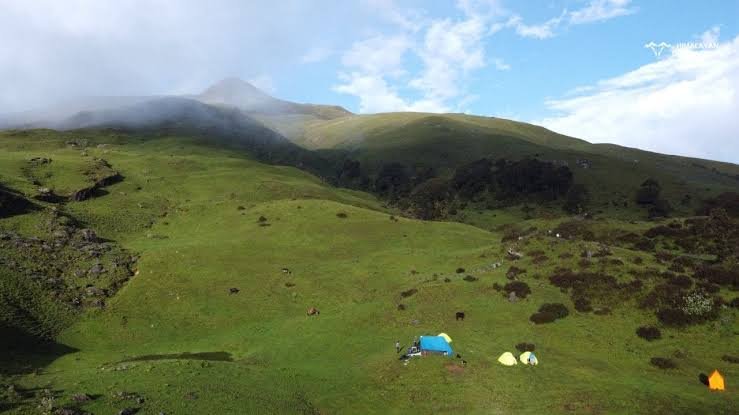
The Kush Kalyan Bugyal Trek climbs from the village of Silla in Uttarkashi district to Kush Kalyan Bugyal, an alpine meadow at approximately 3,838 meters sitting right on the border between Uttarkashi and Tehri Garhwal districts. Kush Kalyan Bugyal Trek Uttarakhand is a loop route through dense oak and pine forest, past several campsites, into a meadow known for its wildflowers, berry plants, medicinal herbs, rhododendrons, and orchids — with the Devan Gad stream flowing nearby and serene views of the Swargarohini, Kala Naag, and Bandarpunch ranges from the top.
A note on trek statistics: Available information on this trek’s total distance varies — one detailed account describes a roughly 50 km, 6–7 day loop from Silla, while a shorter description gives a 35 km, 3-day figure. This guide presents both, along with the day-wise loop itinerary matching the longer description, and recommends confirming current route length and duration with your guide before booking, since this is a genuinely newer, less-documented trek.
Kush Kalyan Bugyal ,A Colorful Alpine Meadow Between Two Districts
Kush Kalyan Bugyal is a large alpine meadow at approximately 3,838 meters on the border of Uttarkashi and Tehri Garhwal districts in the Garhwal Himalaya, reached by a multi-day loop trek starting from Silla village.
The meadow is genuinely distinctive for its plant diversity — wildflowers, berry plants, medicinal herbs, rhododendrons, and orchids cover the knee-length grassland, and the Devan Gad stream flowing nearby serves as a water source for surrounding villages. From the top of Kush Kalyan, trekkers get serene, sweeping views of the Swargarohini, Kala Naag, and Bandarpunch ranges — a genuinely rewarding payoff for a trek that remains far less crowded than Dayara Bugyal or other better-known Uttarkashi meadows.
Trek Overview
| Detail | Information |
|---|---|
| Base village | Silla, Uttarkashi district (~7,600 ft / ~2,316 m) |
| Starting/ending point | Silla (loop trek) |
| Trek distance | ~15km |
| Trek duration | 3 days (shorter account) to 6–7 days (detailed loop itinerary) |
| Maximum altitude | ~3,838 m (Kush Kalyan Bugyal) |
| Difficulty | Easy to Moderate |
| Trail type | Loop, starting and ending at Silla |
| Camping | Yes, multiple established campsites along the loop |
| Best season | Verify current season recommendations; general Himalayan bugyal trekking season applies (spring through autumn) |
| Location | Border of Uttarkashi and Tehri Garhwal districts |
Why Choose the Kush Kalyan Bugyal Trek?
Kush Kalyan Bugyal offers a genuine alpine meadow experience without the crowd levels of Dayara Bugyal or other more established Uttarkashi treks — this remains a comparatively newer, less-documented route, which means fewer trekkers on the trail and a more solitary, unhurried experience. The trek’s core appeal is its landscape variety: dense oak and pine forest transitioning into high-altitude terrain, several streams and waterfalls along the way, and finally the meadow itself, with knee-length wildflower-covered grass stretching toward panoramic Himalayan views.
Beyond the scenery, the trek passes through small Garhwal villages, giving genuine opportunities to interact with local communities and learn about their way of life — a cultural dimension that adds real depth beyond the purely scenic reward. The multiple established campsites along the loop (Silla Chhani, Kush Kalyan Bugyal, Bawani, Kyarki) each offer their own character, making the multi-day version of this trek feel like a genuine journey through different landscapes rather than a single up-and-back walk.
Interested in a genuinely offbeat alpine meadow trek with real solitude? Kashi of North organizes guided Kush Kalyan Bugyal Trek packages — WhatsApp +91 7253079221.
Day-wise Trek Itinerary
Note: This itinerary reflects the longer, 6–7 day loop version of the trek. A shorter 3-day version is also referenced in available trekking accounts — confirm which itinerary length matches your booking before departure.
| Day | Route | Notes |
|---|---|---|
| Day 1 | Dehradun to Silla (drive); gradual uphill climb through oak and pine forest to Silla Chhani campsite | Passes streams and waterfalls |
| Day 2 | Silla Chhani to Kush Kalyan Bugyal campsite | Moderate uphill climb, forest transitioning to alpine terrain, first views of snow-capped peaks |
| Day 3 | Kush Kalyan Bugyal to Bawani campsite | Downhill trek through the meadow itself, vast green pastures |
| Day 4 | Bawani to Kyarki campsite | Moderate uphill climb back through oak and pine forest, more peak views |
| Day 5 | Kyarki to Silla | Downhill trek back through the meadows to the base village |
| Day 6–7 | Silla to Dehradun (drive), departure | Return journey |
This loop structure — climbing up through one route, crossing the meadow itself, and descending through a different combination of campsites — is part of what makes the longer version of this trek genuinely varied rather than a simple out-and-back.
Want this itinerary confirmed and adjusted for current trail conditions? Kashi of North can arrange a guided trek matched to your available days — call or WhatsApp +91 7253079221.
Trek Distance
Available accounts of this trek give differing total distances — one describes approximately 50 km covered over 6–7 days via the full Silla Chhani–Kush Kalyan–Bawani–Kyarki loop, while another gives a shorter 35 km figure typically covered over 3 days. Given this is a newer and less extensively documented trek, confirm the current, accurate route distance and itinerary length with your guide or operator before booking, since trail development and route options may have changed since these accounts were written.
Trek Difficulty
The Kush Kalyan Bugyal Trek is generally described as Easy to Moderate, involving gradual to moderate uphill climbs through forest terrain with genuine elevation gain reaching close to 3,838 meters at the highest point.
The trail alternates between gradual and moderate uphill sections through oak and pine forest, with several stream and waterfall crossings, before opening into the meadow itself. Weather and altitude both become more significant factors as the trek approaches its highest points — proper acclimatization and layered clothing matter here as on any trek reaching close to 4,000 meters. Given the trek’s relatively newer status, navigation and trail-marking may be less established than on more commercially developed routes, making an experienced local guide a genuinely valuable addition rather than an optional extra.
Mountain Views
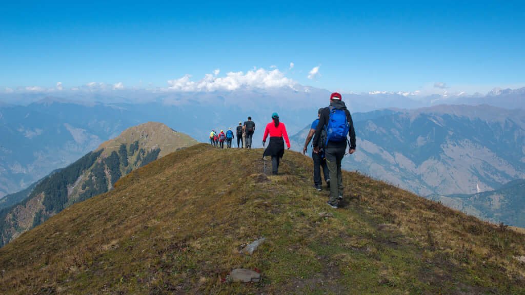
From the top of Kush Kalyan Bugyal, trekkers get views of the Swargarohini, Kala Naag, and Bandarpunch ranges — a genuine panorama of some of the Garhwal Himalaya’s most recognizable peaks.
These views are described consistently across available accounts as one of the trek’s defining rewards, best experienced in clear weather from the meadow’s higher sections. As with any high-altitude viewpoint, actual visibility depends on current weather and seasonal conditions — verify expectations with your guide based on the time of year you’re trekking.
Best Time to Visit
Given the limited season-specific detail available for this newer trek, the general Himalayan bugyal trekking pattern applies: spring and early summer for wildflower bloom and clearing snow, monsoon generally avoided given landslide and trail-condition risk on Himalayan forest trails, and autumn for the clearest mountain visibility. Winter access is likely limited given the trek’s altitude approaching 3,838 meters, similar to other high-altitude Uttarkashi bugyals. Verify current seasonal recommendations with your guide or operator, since specific month-by-month conditions for this particular route aren’t as extensively documented as for more established treks like Dayara Bugyal.
Month-wise Weather Guide
| Season | General Conditions | Recommended? |
|---|---|---|
| Spring | Wildflower bloom likely, snow clearing at altitude | Verify current conditions |
| Summer (pre-monsoon) | Green meadows, moderate temperatures | Generally favorable |
| Monsoon | Rain, landslide risk on forest trails | Generally avoided |
| Autumn | Clear skies, best mountain visibility | Likely the best window |
| Winter | Snow at altitude, limited access likely | Verify with guide |
Flora and Fauna
The meadow itself is notably diverse botanically — wildflowers, berry plants, medicinal herbs, rhododendrons, and orchids all grow across the knee-length grassland, alongside the oak and pine forest that dominates the lower trail sections. Wildlife documented in the region includes the Himalayan monal (Uttarakhand’s state bird), blue sheep, and black bear, alongside various Himalayan birds and insects that add to the trek’s biodiversity. As with all Himalayan wildlife encounters, sightings of larger mammals are occasional rather than guaranteed, and should be approached with standard wildlife-awareness precautions rather than expectation.
Camping Experience
The trek’s established campsites — Silla Chhani, Kush Kalyan Bugyal, Bawani, and Kyarki — are each described as picturesque, set in genuinely scenic locations along the loop. Water is generally available from the Devan Gad stream and other nearby sources, though it should always be purified before drinking. Follow Leave No Trace principles throughout — camp only in established sites, avoid open fires where inappropriate, and carry out all waste given the minimal infrastructure on this less-developed route.
Want your camping gear and trek meals fully organized across all four campsites? Kashi of North handles the full camping logistics as part of its trek packages — WhatsApp +91 7253079221.
Photography Guide
The meadow’s wildflower diversity — including rhododendrons and orchids alongside more typical alpine species — offers strong close-up and wide-angle compositions, particularly in the earlier bloom period. The Swargarohini, Kala Naag, and Bandarpunch panorama from the meadow’s higher sections is the trek’s signature landscape shot, best captured in clear morning or late-afternoon light. The forest sections along the trail, with their streams and waterfalls, offer good forest-interior photography opportunities. Given this trek’s lower profile compared to more developed routes, night sky photography from any of the four campsites likely benefits from minimal light pollution, though verify current camping arrangements with your guide. Drone flying in this district requires prior civil aviation and forest authorization — confirm current regulations before bringing one.
Packing List
| Category | Items |
|---|---|
| Clothing | Thermal base layers, fleece mid-layer, down jacket, waterproof shell, trekking trousers |
| Footwear | Broken-in waterproof trekking boots, warm socks, camp sandals |
| Trek gear | Trekking poles, headlamp with spare batteries, appropriately sized backpack |
| Medical | First-aid kit, altitude medication (consult a doctor), blister care |
| Electronics | Camera, spare batteries, power bank |
| Documents | Government ID, emergency contact list |
Food During the Trek
Meals on a guided trek are typically camp-prepared, with hearty, high-calorie food suited to multi-day forest and alpine trekking. Carry water purification tablets or a filter for stream water along the route, particularly given the Devan Gad and other natural sources used along the trail. High-energy trail snacks — nuts, dried fruit, energy bars — are worth carrying for the walking sections between camps.
Fitness Preparation
Given the trek’s genuine elevation gain toward 3,838 meters and multi-day duration, basic cardiovascular preparation — regular walking, jogging, or cycling in the weeks before departure — meaningfully improves comfort on the gradual and moderate uphill sections. Some leg and core strength work helps with the sustained daily climbs through forest terrain, and general acclimatization awareness matters as the trek approaches its highest points.
Safety Tips
Given the elevation gain toward nearly 3,838 meters, basic altitude awareness is worth maintaining — watch for headache, nausea, or dizziness, and communicate any symptoms to your guide promptly. Stream crossings along the trail require care, particularly after rain. Weather at this altitude can shift quickly, so pack layered clothing and follow your guide’s judgment on daily pacing. Given the trek’s newer, less-commercially-developed status, an experienced guide familiar with current trail and campsite conditions is genuinely valuable for both navigation and emergency planning.
Responsible Trekking
Follow Leave No Trace principles throughout this route — carry out all waste, since infrastructure along this less-developed trek is minimal. Respect the local villages you pass through, approaching interactions with genuine curiosity rather than treating residents as a photo backdrop. Protect the meadow’s notable plant diversity — avoid picking wildflowers, berries, or medicinal herbs, and stay on established paths through the grassland rather than creating new routes across the fragile alpine ecosystem.
How to Reach Silla
Silla village, the trek’s base and loop start/end point, is reached via Dehradun and Uttarkashi by road.
By Road: Dehradun → Rishikesh/Uttarkashi route → onward to Silla, following mountain roads into the Uttarkashi district interior.
By Air: The nearest airport is Jolly Grant Airport, Dehradun.
By Train: The nearest railway stations are Rishikesh and Haridwar.
By Taxi/Self-Drive: An SUV is recommended given the mountain roads involved in reaching Silla.
Prefer not to arrange the Dehradun–Silla transport yourself? Kashi of North provides private taxi service for the full route as part of your trek package — WhatsApp +91 7253079221.
Distance Chart
| Origin | Distance to Silla | Notes |
|---|---|---|
| Delhi | Verify current distance | Via Dehradun/Rishikesh route |
| Dehradun | Verify current distance | Standard road journey to Uttarkashi district interior |
| Uttarkashi | Verify current distance | Silla lies within Uttarkashi district |
| Dayara Bugyal | Separate trailhead | Different Uttarkashi meadow trek |
| Harsil | Separate approach | Different valley within the district |
| Gangnani | Via Uttarkashi | Separate stop on Gangotri highway |
Note: Precise road distances from major cities to Silla village aren’t consistently documented across available sources for this trek — confirm exact figures with your guide or operator when booking.
Accommodation
Before/After the Trek
| Location | Type | Notes |
|---|---|---|
| Silla | Basic village accommodation, if available | Base village for the trek |
| Uttarkashi | Hotels | Wider range for a pre/post-trek recovery stay |
| Dehradun | Hotels | Common overnight stop before/after the drive to Silla |
On the Trek
Tented camping is standard at Silla Chhani, Kush Kalyan Bugyal, Bawani, and Kyarki — arranged as part of a guided package.
Want your Silla and Uttarkashi accommodation booked alongside your trek package? Kashi of North handles the full arrangement — call or WhatsApp +91 7253079221.
Nearby Attractions
| Place | Notes |
|---|---|
| Dayara Bugyal | Uttarakhand’s more established alpine meadow trek, separate trailhead |
| Harunta Bugyal | Another offbeat Uttarkashi meadow, near Chaurangi Khal |
| Gidara Bugyal | Additional remote meadow destination in the district |
| Harsil Valley | Apple orchard valley, separate approach |
| Gangnani | Hot spring stop en route from Uttarkashi |
| Dodital | Forest lake trek near Uttarkashi |
| Uttarkashi | District headquarters, widest services and accommodation |
Want to combine Kush Kalyan Bugyal with another Uttarkashi meadow trek or a wider district tour? Kashi of North plans multi-destination itineraries — WhatsApp +91 7253079221.
Trek Cost
| Category | Notes |
|---|---|
| Budget (self-organized) | Requires own gear and route knowledge given the trek’s less-developed status |
| Standard Guided Trek | Guide, camping, meals, and transport included |
| Premium Trek | Enhanced comfort, experienced trek leader, full support |
| Private Trek | Fully customized dates and pace |
Given the newer, less-commercialized nature of this trek, costs vary considerably by group size, season, camping equipment needs, and transportation arrangements — confirm current, accurate pricing directly rather than relying on any published estimate.
Want an accurate cost breakdown for your group and dates? Kashi of North provides transparent Kush Kalyan Bugyal Trek pricing — call or WhatsApp +91 7253079221.
Conclusion
Kush Kalyan Bugyal offers a genuinely varied alpine meadow experience — forest, streams, waterfalls, four distinct campsites, and a meadow known for a botanical diversity that goes well beyond typical high-altitude grassland, all capped by clear views of the Swargarohini, Kala Naag, and Bandarpunch ranges. Its status as a comparatively newer, less-documented trek means real solitude on the trail, though it also means confirming current route details and conditions with an experienced guide matters more here than on Uttarakhand’s better-established treks.
Ready to plan your Kush Kalyan Bugyal Trek? Kashi of North organizes guided treks, local trek leaders, camping arrangements, hotel bookings, taxi services, and fully customized Uttarkashi trekking itineraries.
📞 Call/WhatsApp: +91 7253079221 📧 Email: kashiofnorth@gmail.com 🌐 Website: kashiofnorth.com
Frequently Asked Questions
1. What is Kush Kalyan Bugyal? A large alpine meadow at approximately 3,838 meters on the border of Uttarkashi and Tehri Garhwal districts, known for its diverse wildflowers, berry plants, and medicinal herbs.
2. Where does the Kush Kalyan Bugyal Trek start? From Silla village in Uttarkashi district, at roughly 7,600 feet (2,316 meters).
3. What is the altitude of Kush Kalyan Bugyal? Approximately 3,838 meters.
4. How long is the Kush Kalyan Bugyal Trek? Distance figures vary across available sources — roughly 35 km over 3 days in one account, or approximately 50 km over 6–7 days in a more detailed loop itinerary. Confirm current details with your guide.
5. How difficult is the Kush Kalyan Bugyal Trek? Generally described as Easy to Moderate, with gradual to moderate uphill climbs through forest terrain.
6. What campsites are on the Kush Kalyan Bugyal Trek? Silla Chhani, Kush Kalyan Bugyal, Bawani, and Kyarki, in the longer loop itinerary.
7. What peaks are visible from Kush Kalyan Bugyal? Swargarohini, Kala Naag, and Bandarpunch ranges are visible from the top of the meadow.
8. Is the Kush Kalyan Bugyal Trek suitable for beginners? Generally rated easy to moderate, though given its newer, less-documented status, going with an experienced guide is recommended.
9. What flora will I see on this trek? Wildflowers, berry plants, medicinal herbs, rhododendrons, and orchids across the meadow, alongside oak and pine forest on the lower trail sections.
10. What wildlife might I see on the Kush Kalyan Bugyal Trek? Himalayan monal, blue sheep, and black bear are documented in the region, alongside various Himalayan birds.
11. What is the Devan Gad? A stream flowing near Kush Kalyan Bugyal that serves as a water source for nearby villages and the trek route.
12. Is camping required for this trek? Yes, tented camping at established sites along the loop is the standard accommodation.
13. What is the best time to visit Kush Kalyan Bugyal? Specific seasonal detail for this trek is limited; general Himalayan bugyal trekking patterns (spring through autumn, avoiding peak monsoon) likely apply — verify current recommendations with your guide.
14. Is a guide necessary for the Kush Kalyan Bugyal Trek? Strongly recommended, given the trek’s newer status and less-established trail infrastructure compared to routes like Dayara Bugyal.
15. How do I reach Silla village? Via Dehradun and the Uttarkashi district road network — confirm exact route and distance with your operator.
16. What is the trek cost for Kush Kalyan Bugyal? Costs vary by group size, itinerary length, and inclusions — contact Kashi of North for current, accurate pricing.
17. Is this trek crowded? No, it remains a comparatively newer and less-visited route compared to Dayara Bugyal and other established Uttarkashi meadows.
18. What should I pack for the Kush Kalyan Bugyal Trek? Warm layered clothing, waterproof trekking boots, trekking poles, and a headlamp — see the full packing list above.
19. Are there stream crossings on this trek? Yes, the route crosses several streams and waterfalls, particularly in the forested lower sections.
20. What local culture will I experience on this trek? The route passes through small Garhwal villages, offering genuine opportunities to interact with local communities.
21. Is the trek a loop or an out-and-back route? It’s structured as a loop, starting and ending at Silla village via different combinations of campsites.
22. What district is Kush Kalyan Bugyal in? It sits on the border of Uttarkashi and Tehri Garhwal districts.
23. Can I do a shorter version of this trek? Yes, a shorter roughly 35 km, 3-day version is referenced in some accounts, alongside the longer 50 km loop — confirm which fits your available time.
24. Is snow leopard habitat present near Kush Kalyan Bugyal? Not specifically documented for this trek in available sources — the broader Garhwal high-altitude region does support snow leopard habitat, though sightings would be exceptionally rare.
25. What nearby treks can I combine with Kush Kalyan Bugyal? Dayara Bugyal, Harunta Bugyal, and Gidara Bugyal are other Uttarkashi meadow treks that could be combined into a longer district-wide trekking trip.
26. Does Kashi of North offer guided Kush Kalyan Bugyal Trek packages? Yes, including trek leaders, camping arrangements, transportation, and hotel bookings — reach out via WhatsApp at +91 7253079221.