

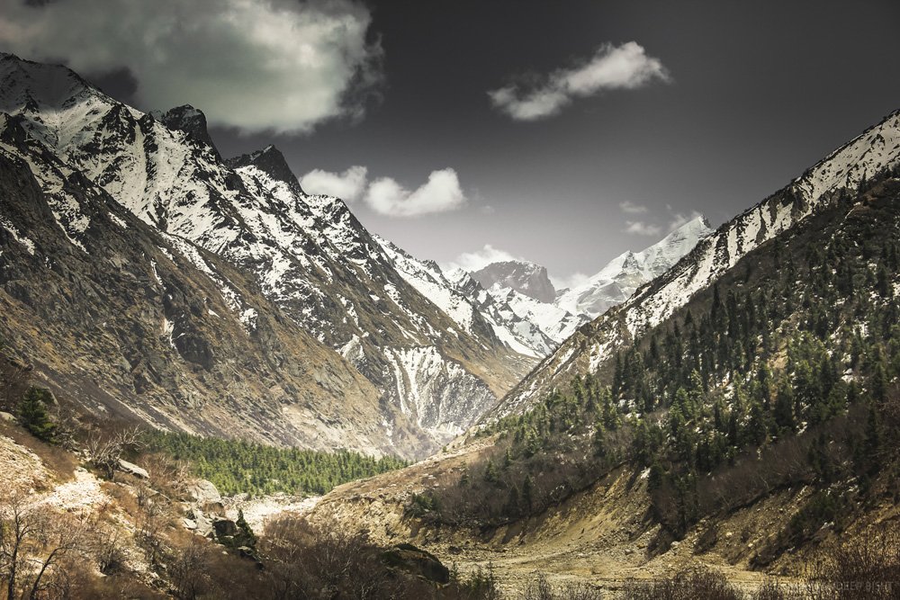
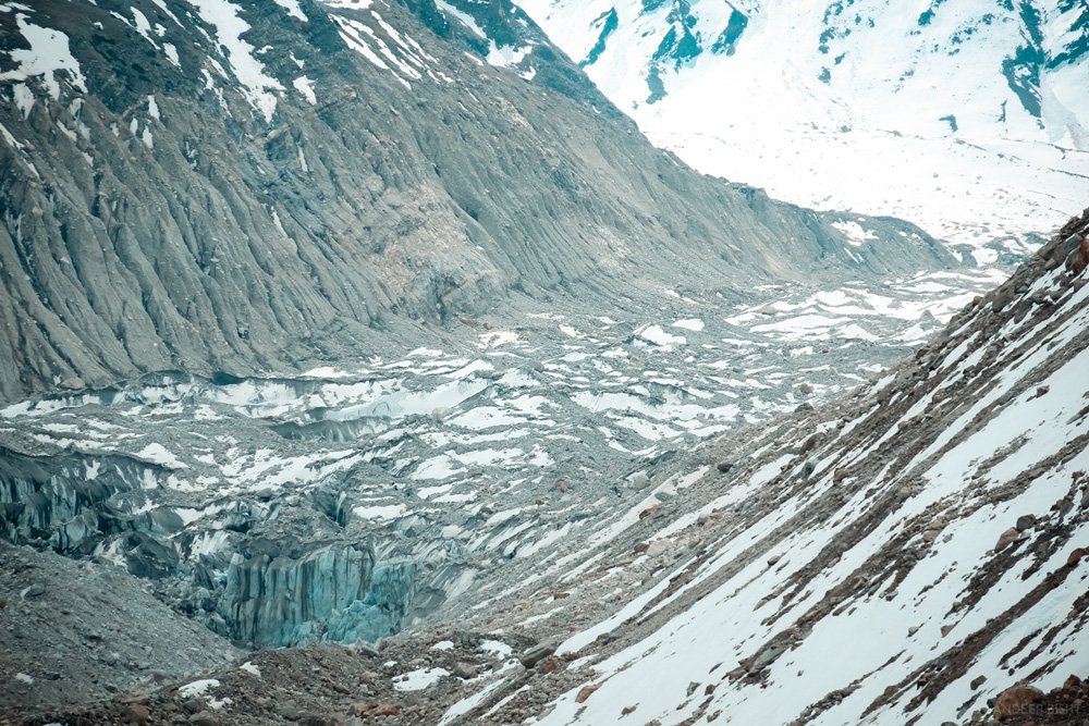
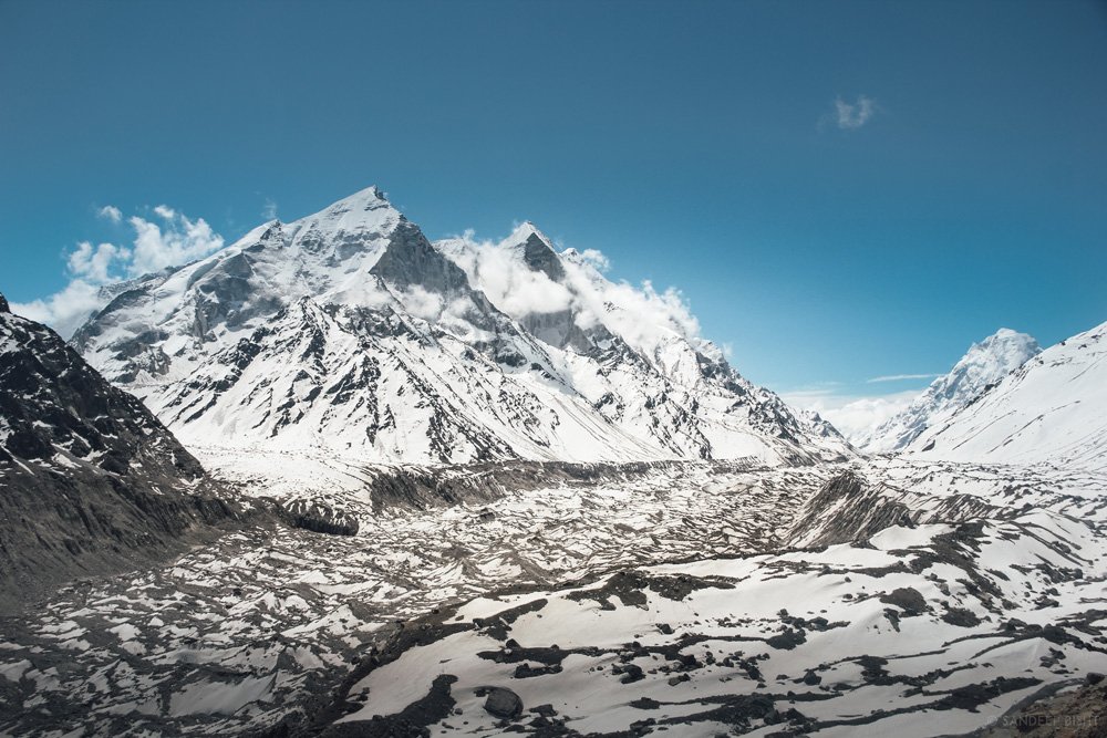
The Gaumukh Trek follows the Bhagirathi River roughly 18 km from Gangotri temple town to Gaumukh — “cow’s mouth” — the snout of the Gangotri Glacier at around 4,000 meters, where the meltwater that becomes the sacred Ganga first emerges from ice and rock. It’s one of the few treks in India where a physical hike and a religious pilgrimage are genuinely the same journey: Gangotri is one of the four Char Dhams of Uttarakhand, and Gaumukh, roughly a two-day walk further up the valley, is the actual glacial source the temple honors.
This guide covers the complete route through Chirbasa and Bhojbasa, the permit process, difficulty and fitness requirements, cost breakdowns, day-wise itineraries from 2 to 6 days, and more than 35 answered questions — everything needed to plan the Gaumukh Trek properly, whether you’re a first-time trekker or a 50+ pilgrim making a long-held journey to see where the Ganga begins.
Important note: Permit rules, visitor limits, and prices can change. This guide reflects information current as of mid-2026 — verify the latest requirements with the Gangotri National Park Forest Department before booking.
What Is the Gaumukh Trek?
The Gaumukh Trek is an 18 km (one-way) Himalayan trek from Gangotri town to Gaumukh, the snout of the Gangotri Glacier, where the Bhagirathi River — the primary headstream of the Ganga — physically emerges from ice, following a well-marked trail through Chirbasa and Bhojbasa inside Gangotri National Park.
The name Gaumukh translates to “cow’s mouth,” describing the shape of the glacier terminus. Sitting at roughly 3,969–4,023 meters (about 13,000–13,452 feet), Gaumukh isn’t just a trekking destination — it’s regarded as the actual, physical point where the Ganga begins, distinct from Gangotri temple, which is treated as the river’s spiritual and ceremonial origin roughly 18 km downstream. Trekkers routinely continue beyond Gaumukh to Tapovan, Nandanvan, or further toward Vasuki Tal and Kalindi Khal, but the standard Gaumukh Trek itself ends at the glacier snout.
Have you ever thought about actually seeing where a river begins? That’s the pull behind this trek — not a summit, not a meadow, but an origin.
Quick Trek Information
| Detail | Information |
|---|---|
| Starting point | Gangotri (~3,048–3,100 m) |
| Ending point | Gaumukh Glacier (~3,969–4,023 m) |
| Trek distance | ~18 km one-way |
| Duration | 2–6 days depending on itinerary |
| Maximum altitude | ~4,023 m (Gaumukh); higher on Tapovan extension |
| Difficulty | Easy to Moderate |
| Best time | Mid-April–June; mid-September–November |
| Permit required | Yes, mandatory |
| Guide requirement | Not mandatory for standard route; strongly advised for Tapovan |
| Network availability | None beyond Gangotri town |
| Fitness level | Moderate — suitable for many 50+ trekkers with preparation |
| Accommodation | Guesthouses at Gangotri; tents/ashrams at Bhojbasa |
Why the Gaumukh Trek Is Special
Rivers hold a specific place in Indian life — they irrigate fields, sustain cities, and appear throughout scripture and daily ritual, which is part of why the place a sacred river begins carries such weight. On this trek, you don’t walk toward a summit or a meadow; you walk toward an origin. You see two distinct sacred sights on the same journey: Gangotri town, home to the temple regarded as the Ganga’s spiritual descent point, and then Gaumukh itself, the glacier snout where the Bhagirathi physically melts into being.
Before the Ganga becomes the river of prayer, agriculture, and countless cities downstream, she begins here as ancient, untouched ice. Watching that ice become flowing water, with the Bhagirathi Peaks and Mount Meru rising around you, is what makes this trek different from most others in the Himalaya — it combines genuine physical adventure with a sense of witnessing something at its beginning.
The trail is also comparatively gentle. It’s well marked, has no sharp climbs or technical sections, and is genuinely walkable by people of a wide range of ages and fitness levels — including many trekkers in their 50s and beyond who have carried the wish to make this walk for years.
Planning your Gaumukh Trek and want the permit and logistics handled? Kashi of North arranges Gaumukh Trek packages with permits, guides, and accommodation included — WhatsApp +91 7253079221.
About Gangotri Dham
Gangotri Temple, at roughly 3,048–3,100 meters on the banks of the Bhagirathi, is one of the four Char Dhams of Uttarakhand alongside Yamunotri, Kedarnath, and Badrinath, and it’s the starting point for the Gaumukh Trek. Dedicated to Goddess Ganga, the temple is built in white granite in simple, resilient Himalayan stone architecture, and its present structure is credited to Gorkha General Amar Singh Thapa in the early 18th century — part of a broader Gorkha effort to construct and restore important Himalayan pilgrimage sites during their period of expansion into the region (1768–1815).
Although the physical source of the Ganga lies further up at Gaumukh, Gangotri is treated as the river’s spiritual and ceremonial origin — the site where Goddess Ganga is believed to have first descended and manifested in her calmer form before flowing down as the Bhagirathi. The temple follows a strict seasonal cycle, opening annually on Akshaya Tritiya (April–May) and closing around Diwali (October–November); through winter, the idol is moved to Mukhba village, where worship continues until the temple reopens.
Mythology: King Bhagirath and the Descent of Ganga
The following presents Hindu religious tradition as believed and practiced — a devotional narrative, not a historical claim.
According to the Ramayana and various Puranas, King Sagar performed the Ashwamedha Yagna to establish his sovereignty, sending his ceremonial horse to roam freely. Lord Indra, threatened by Sagar’s growing power, secretly stole the horse and hid it near Sage Kapila’s hermitage in Patala Loka. King Sagar’s 60,000 sons, searching for the horse, found it near the sage’s ashram and, mistaking him for the thief, disturbed his meditation — Kapila, angered, reduced all 60,000 princes to ashes, denying their souls liberation.
Generations later, King Bhagiratha, Sagar’s great-grandson, undertook years of intense penance to bring the Ganga down from the heavens so her waters could touch his ancestors’ ashes and free their souls. Ganga agreed but warned that her force could devastate the earth on landing. Bhagiratha then prayed to Lord Shiva, who caught the descending river in his matted locks and released her in controlled streams — one of which became the Bhagirathi, emerging near Gangotri. With the Ganga’s waters finally reaching the ashes of Sagar’s sons, their souls attained moksha. The river’s name, Bhagirathi, honors King Bhagiratha’s role in this story.
This narrative appears across the Valmiki Ramayana, the Srimad Bhagavatam, the Skanda Purana, and the Mahabharata, and it’s the foundation of Gangotri and Gaumukh’s status as sacred landscapes — the reason this trek carries spiritual weight well beyond its scenery.
Trek Highlights
- Gangotri Temple — the spiritual starting point, one of the four Char Dhams
- Gangotri National Park — the protected high-altitude ecosystem the entire trail runs through
- Chirbasa — the first major stop, named for its chir pine forest, with the Bhagirathi flowing calmly beside the trail
- Bhojbasa — the iconic campsite at 3,800 m, named for its Bhojpatra (Himalayan birch) trees, with wide Himalayan views and a genuinely humbling atmosphere
- Gaumukh Glacier — the trek’s destination, where the Bhagirathi emerges directly from ice
- Bhagirathi I, II, III and Mount Meru — snow peaks visible along much of the route
- Ashrams and hermitages — remnants of a long tradition of spiritual seekers, including Swami Tapovan Maharaj and Swami Sundaranand, who spent decades in meditation around Gangotri, Bhojbasa, and Gaumukh
The Trek Route in Detail
Gangotri to Chirbasa (~9 km, 5–6 hours, ~3,550 m)
The trail begins at the Gangotri Forest Check Post and follows the Bhagirathi’s right bank through pine and Deodar forest on a gradual, well-defined ascent. Chirbasa — named for its chir pine cover — is a rest point and campsite where the river runs calm and the surroundings feel unusually serene for a trail this close to a major glacier system. Water is available along the route from the river; this stretch is the gentlest section of the entire trek.
Chirbasa to Bhojbasa (~5 km, 3–4 hours, ~3,800 m)
Forest thins progressively into birch and sparse scrub as the trail climbs. Bhojbasa, named for its Bhojpatra (Himalayan birch) trees, sits directly beside the roaring Bhagirathi with the surrounding peaks fully in view — it’s the only designated overnight zone between Gangotri and Gaumukh, and for many trekkers it’s the most memorable stop on the route. Local staff and pilgrims at Bhojbasa often sing traditional pahadi songs in the evening, adding a distinctly warm, communal note to what is otherwise a stark high-altitude setting. Sunrise and sunset here — golden and pink light hitting the snow-covered peaks across the glacial valley — are widely considered trek highlights in themselves. Many trekkers meditate, chant, or perform a small Ganga Aarti near the campsite.
Bhojbasa to Gaumukh and back (~11 km round trip, 7–8 hours, up to ~4,023 m)
The final push crosses a boulder field and moraine — physically harder than the distance suggests, given the altitude and terrain. As you approach, the scale of the Gangotri Glacier becomes fully apparent, with the ice wall reaching 15–30 meters at points near the snout. Watching the Bhagirathi emerge directly from the ice, surrounded by mountains and snow, is the trek’s central moment — most itineraries return to Bhojbasa or Chirbasa the same day, since camping is not permitted at Gaumukh itself.
Optional Extension to Tapovan
Tapovan (~4,460 m) is a high meadow beyond Gaumukh with direct views of Shivling, reached by crossing a stretch of the glacier itself. This extension adds real technical difficulty and altitude exposure and is recommended only for acclimatized, experienced trekkers — ideally with a guide.
Gaumukh Trek Distance Table
| Origin | Distance to Gangotri | Approx. Time |
|---|---|---|
| Delhi | ~490–510 km | 13–15 hours |
| Haridwar | ~262–278 km | 8–9 hours |
| Rishikesh | ~250–265 km | 7–9 hours |
| Dehradun | ~248–260 km | 8–9 hours |
| Uttarkashi | ~100 km | 3–3.5 hours |
| Harsil | ~25–28 km | 45–60 minutes |
| Trek Segment | Distance | Time |
|---|---|---|
| Gangotri to Chirbasa | ~9 km | 5–6 hours |
| Chirbasa to Bhojbasa | ~5 km | 3–4 hours |
| Bhojbasa to Gaumukh (one-way) | ~4 km | 2–3 hours |
| Bhojbasa to Gaumukh and back | ~11 km | 7–8 hours |
| Gaumukh to Tapovan | ~6 km (glacier crossing) | 3–4 hours |
Day-wise Itinerary
Shorter Options
2 Days (fit, experienced trekkers only): Gangotri to Bhojbasa in one long day, Bhojbasa to Gaumukh and back to Gangotri the next — physically demanding and not recommended for beginners or first-time high-altitude trekkers.
3 Days: Day 1 — Gangotri to Bhojbasa. Day 2 — Bhojbasa to Gaumukh and back to Bhojbasa. Day 3 — Bhojbasa to Gangotri.
4 Days: Day 1 — Gangotri to Chirbasa. Day 2 — Chirbasa to Bhojbasa. Day 3 — Bhojbasa to Gaumukh and back to Bhojbasa. Day 4 — Bhojbasa to Gangotri.
5 Days: As above, with an added acclimatization day at Gangotri before starting.
Premium/Photography Trek Plan: Extended stay at Bhojbasa (2 nights) to capture both sunrise and sunset light on the Bhagirathi Peaks, with a dedicated pre-dawn departure to Gaumukh for the best glacier light.
Want a day-wise plan matched to your fitness level and available days? Kashi of North designs custom Gaumukh Trek itineraries — call or WhatsApp +91 7253079221.
Gaumukh Trek Packages
| Package Type | What’s Typically Included | What’s Excluded |
|---|---|---|
| Budget | Permit assistance, basic Bhojbasa ashram stay, shared transport | Personal gear, porter, private vehicle |
| Standard | Permit, guide, Gangotri guesthouse + Bhojbasa stay, meals | Personal trekking gear, insurance |
| Premium | Permit, guide, porter, better accommodation, private transport, meals | Personal gear, tips |
| Private Trek | Fully customized dates, private guide and vehicle | — |
| Group Trek | Shared costs, fixed departure dates | Flexibility on dates |
Prices vary significantly by season, group size, and inclusions — always confirm current package pricing directly before booking rather than relying on fixed figures.
Choosing between a budget, standard, or premium package? Kashi of North can walk you through current Gaumukh Trek package options based on your dates and group size.
Gaumukh Trek Cost
Rough cost components for the Gaumukh Trek include:
- Permit: ~₹150/person (Indian nationals; verify current fee)
- Transport: Dehradun/Rishikesh to Gangotri, round trip
- Guide: Optional for the standard route, effectively necessary for Tapovan
- Porter: For those not carrying their own pack
- Accommodation: Gangotri guesthouse plus Bhojbasa ashram or GMVN
- Food: Meals at Gangotri and Bhojbasa; carried food beyond Bhojbasa
- Equipment: Rental or purchase of cold-weather gear if not already owned
| Category | Per Person (approx.) |
|---|---|
| Budget trekker | ₹10,000–₹14,000 (excluding transport from home city) |
| Mid-range | ₹14,000–₹18,000 |
| Premium/private | ₹18,000–₹30,000+ |
These are planning estimates, not fixed prices — permit fees, accommodation rates, and transport costs change seasonally.
Gaumukh Trek Permit
A permit is mandatory for the Gaumukh Trek because the route runs entirely through Gangotri National Park, a protected high-altitude ecosystem where the Forest Department regulates daily visitor numbers to limit ecological impact.
Why a Permit Is Required
Gangotri National Park protects the glacier system, the Bhagirathi headwaters, and documented wildlife including snow leopard, Himalayan tahr, and blue sheep. Permits allow the Forest Department to manage visitor load, maintain trail conditions, and respond to emergencies.
Documents Required
- Government-issued photo ID (Aadhaar Card preferred)
- Passport-size photographs (carry a few spares)
- For foreign nationals: passport
Where and How to Apply
Permits are issued at the Forest Department counter at the Gangotri National Park gate, in person — there is currently no online application process for the standard Gaumukh permit. Arrive early during peak season, since the daily trekker limit (around 150/day) can fill by mid-morning.
Visitor Limits and Rules
- Approximately 150 trekkers permitted per day (verify current cap)
- Camping is not allowed at Gaumukh itself — Bhojbasa is the only designated overnight zone
- Drones are strictly prohibited throughout the park
- Plastic carrying restrictions apply — carry reusable containers rather than single-use plastic
- Do not collect plants, rocks, or any natural material
- Stay on the marked trail
Want your Gaumukh Trek permit sorted before you even arrive at Gangotri? Kashi of North handles permit logistics as part of its trek packages — WhatsApp +91 7253079221.
Trek Difficulty and Eligibility
The Gaumukh Trek is rated Easy to Moderate — a well-marked trail with no technical climbing, though the altitude (up to ~4,023 m) and the boulder/moraine section near Gaumukh itself make genuine fitness and acclimatization important.
Age and Fitness Requirements
- Minimum age: typically 14 years
- First-timers are welcome, though prior trekking experience helps
- Fitness benchmark: comfortably jogging 5 km in 30 minutes or 10 km in 70 minutes, or cycling 18 km in 50 minutes, without excessive strain
- Backpack carrying capacity: 10–12 kg if carrying your own pack; 3–5 kg if using an off-load/porter service
- Trekkers with a BMI notably outside the 18–27 range should consult a trek coordinator before booking
What Makes It Manageable for Older or First-Time Trekkers
The trail has no sharp climbs or technical sections, allows a self-set pace with frequent rest stops, and includes a natural acclimatization structure through Chirbasa and Bhojbasa before the final push to Gaumukh. This is genuinely why the trek remains a long-held goal for many trekkers in their 50s and beyond — the physical demand is real but manageable with preparation, not technical mountaineering.
Preparation Recommendations
- Build cardiovascular fitness over 4–6 weeks before the trek (walking, jogging, cycling, stair climbing)
- Practice with a loaded backpack if carrying your own gear
- Spend at least one acclimatization night at Gangotri before starting
- Consult a doctor about high-altitude precautions if you have cardiac, respiratory, or other relevant conditions
Best Time to Visit
Mid-April to June and mid-September to November are the two windows when the Gaumukh Trek is open and conditions are safest, with the trail closed roughly mid-June to mid-September during the monsoon.
- April–June: Trail opens progressively as snow clears; comfortable trekking temperatures; busiest period aligning with the Char Dham season.
- Mid-June to mid-September (monsoon): Trail closed — this closure exists because the route becomes genuinely dangerous with landslide and flash-flood risk.
- Mid-September–November: The finest window — clear post-monsoon skies, excellent visibility, and comfortable if cooler temperatures. Trail closes again as winter snow arrives, typically by mid-to-late November.
- December–March: Closed entirely; the region is inaccessible under snow.
Month-wise Weather Guide
| Month | Day Temp | Night Temp | Trek Status | Recommended Gear |
|---|---|---|---|---|
| April | 4°C to 12°C | -4°C to 0°C | Opens progressively | Full winter layers |
| May | 8°C to 18°C | 0°C to 4°C | Open | Warm layers, sun protection |
| June (early) | 10°C to 20°C | 4°C to 8°C | Open, closes mid-month | Warm layers |
| July–Aug | — | — | Closed | N/A |
| September (mid–late) | 8°C to 16°C | 2°C to 6°C | Reopens | Warm layers, rain shell |
| October | 4°C to 12°C | -2°C to 2°C | Open, excellent | Insulated jacket, thermals |
| November (early) | -4°C to 4°C | -8°C to -12°C | Closing | Full winter gear |
Camping beyond Bhojbasa is not permitted; personal tent camping at Bhojbasa’s designated area is allowed for those equipped for it.
Want your Bhojbasa and Gangotri stays booked before peak season fills up? Kashi of North handles trek accommodation bookings alongside permits and transport.
Food and Water
Meals are available at Gangotri guesthouses and at Bhojbasa’s ashrams, but Chirbasa has only a basic tea stall, and beyond Bhojbasa there’s no food available at all — carry everything needed for the Gaumukh push. High-energy snacks (dry fruits, nuts, energy bars, glucose tablets) and a thermos of hot tea or soup help maintain energy and core temperature at altitude. Water is available from the Bhagirathi along most of the route, but carry purification tablets and fill up at Bhojbasa before the final stretch to Gaumukh.
Wildlife
Gangotri National Park’s documented species along the trek corridor include the snow leopard (flagship species, rarely sighted), Himalayan tahr, blue sheep (bharal), musk deer, and Himalayan griffon, alongside the Himalayan monal — Uttarakhand’s state bird. Early morning is the best window for wildlife and raptor observation; a good pair of binoculars adds significantly to the experience.
Safety Tips
Altitude sickness is a genuine risk at Bhojbasa (3,800 m) and Gaumukh (~4,000 m). Acclimatize at Gangotri for at least one night before starting, hydrate generously, avoid alcohol, and watch for headache, nausea, dizziness, and fatigue — confusion or a pink frothy cough are severe warning signs requiring immediate descent.
Weather can shift within minutes at this altitude — start each day’s walk by 6:00–7:00 AM to be back before afternoon cloud builds.
Responsible trekking: stay on the marked trail, camp only at Bhojbasa, carry out all waste, and don’t collect plants, rocks, or minerals.
Solo trekking is possible on the standard Gangotri–Gaumukh route given its well-marked trail, but a guide is strongly recommended, particularly for the Tapovan extension, which involves glacier crossing.
Trek insurance isn’t mandatory but is strongly advised — look for coverage that includes high-altitude trekking and emergency evacuation.
Photography Guide
Sunrise and sunset at Bhojbasa — golden and pink light on the Bhagirathi Peaks across the glacial valley — are among the trek’s most photographed moments. At Gaumukh itself, the ice wall and the river’s emergence reward both wide-angle shots capturing scale and closer compositions of ice texture. Wildlife photography benefits from a 400mm+ telephoto lens and patience, particularly for raptors riding thermals in early morning. Drones are strictly prohibited throughout Gangotri National Park — this is a legal restriction, not a suggestion. Cold drains camera batteries quickly, so carry spares in an inside pocket, and a polarizing filter helps cut haze and reveal the Bhagirathi’s color at lower elevations.
Nearby Places
| Place | Distance from Gangotri | Notes |
|---|---|---|
| Surya Kund | ~1 km | Traditional bathing pool |
| Gauri Kund | ~500 m | Quieter meditation spot |
| Pandava Gufa | ~1 km upstream | Cave linked to Pandava tradition |
| Bhaironghati | ~9 km | Confluence of Bhagirathi and Jadh Ganga |
| Harsil | ~25–28 km | Apple orchard valley, good lower-altitude base |
| Dharali | ~20–22 km | Quiet orchard village |
| Mukhba | ~21–23 km | Winter home of Goddess Ganga |
| Nelong Valley | Via Bhaironghati | Restricted cold-desert zone, separate permit required |
| Kedartal Trek | ~17 km from Gangotri | More demanding alternative/addition trek |
Practical Information
Mobile network: BSNL and Jio work at Gangotri town; no reliable network beyond that point on the trail.
ATMs: Limited and seasonal in Gangotri — withdraw cash in Uttarkashi before heading up.
Fuel: Seasonal in Gangotri; fill up completely in Uttarkashi.
Medical facilities: Basic first aid only at Gangotri; the nearest hospital is in Uttarkashi, roughly 100 km away.
Local guides: Available through the Forest Department at Gangotri; recommended for Tapovan and beyond.
Emergency Contacts
| Service | Contact |
|---|---|
| Emergency | 112 |
| Uttarakhand Tourist Helpline | 1364 |
| SDRF Uttarkashi | 01374-222694 |
| Kashi of North Travel Assistance | +91 7253079221 |
Conclusion
The Gaumukh Trek is one of the few Himalayan journeys where the destination is genuinely an origin rather than a summit. You walk beside the Bhagirathi through pine and birch forest, camp beneath peaks that have watched pilgrims and sages pass for centuries, and finally stand where a river — one that has shaped millions of lives downstream — first takes form from ancient ice. It combines real physical trekking with a spiritual weight that few other routes in India can match, and its gentle gradient makes it genuinely achievable for a wide range of trekkers, including many making this walk later in life as a long-held goal finally realized.
Ready to plan your Gaumukh Trek? Kashi of North handles permits, experienced local guides, hotel and Bhojbasa accommodation bookings, taxi services, and fully customized trek itineraries.
📞 Call/WhatsApp: +91 7253079221 📧 Email: kashiofnorth@gmail.com 🌐 Website: kashiofnorth.com
Frequently Asked Questions
1. What is the Gaumukh Trek? An 18 km (one-way) trek from Gangotri temple town to Gaumukh, the snout of the Gangotri Glacier and the physical source of the Bhagirathi River.
2. How long is the Gaumukh Trek? Approximately 18 km one-way from Gangotri, typically completed over 2 to 6 days depending on the itinerary chosen.
3. What is the Gaumukh Trek cost? Roughly ₹6,000–₹30,000+ per person depending on package type, group size, and season — these are planning estimates, not fixed prices.
4. Is a permit required for the Gaumukh Trek? Yes, mandatory, issued at the Forest Department counter at the Gangotri National Park gate, with a daily visitor cap of roughly 150 trekkers.
5. What is the difficulty level of the Gaumukh Trek? Easy to Moderate — a well-marked, non-technical trail, though altitude and the boulder section near Gaumukh require genuine fitness.
6. What is the best time for the Gaumukh Trek? Mid-April to June, and mid-September to November; the trail is closed roughly mid-June to mid-September during monsoon.
7. What is the maximum altitude on the Gaumukh Trek? Approximately 4,023 meters at Gaumukh; higher if extending to Tapovan (~4,460 m).
8. Is the Gaumukh Trek suitable for beginners? Yes, with basic fitness preparation — the trail has no technical sections, though altitude awareness is essential.
9. Is the Gaumukh Trek suitable for people over 50? Yes, and it’s a common long-held goal for many senior trekkers, given the gentle gradient, self-set pace, and frequent rest opportunities.
10. What is the minimum age for the Gaumukh Trek? Typically 14 years.
11. Do I need a guide for the Gaumukh Trek? Not mandatory for the standard Gangotri–Gaumukh route, but strongly recommended, and effectively necessary for the Tapovan extension.
12. Can I camp at Gaumukh? No, camping is not permitted at the glacier snout itself — Bhojbasa is the only designated overnight zone.
13. What is Bhojbasa? The trek’s main campsite at roughly 3,800 meters, named for its Bhojpatra (birch) trees, offering GMVN, ashram, and personal tent camping options.
14. What is Chirbasa? The first major stop on the trek at roughly 3,550 meters, named for its chir pine forest, about 9 km from Gangotri.
15. What documents do I need for the Gaumukh Trek permit? A government-issued photo ID (Aadhaar preferred) and passport-size photographs; foreign nationals need a passport.
16. Can I apply for the Gaumukh permit online? No, as of current information the permit is issued in person at the Gangotri National Park gate — verify before travel in case this changes.
17. What is the fitness requirement for the Gaumukh Trek? Comfortably jogging 5 km in 30 minutes or 10 km in 70 minutes without excessive strain, or cycling 18 km in 50 minutes.
18. How much weight can I carry on the trek? 10–12 kg if carrying your own backpack; 3–5 kg if using an off-load/porter service.
19. Is mobile network available on the Gaumukh Trek? BSNL and Jio work at Gangotri town; there’s no reliable network beyond that point.
20. What wildlife might I see on the trek? Blue sheep (bharal), Himalayan tahr, musk deer, Himalayan griffon, and the Himalayan monal; snow leopard sightings are rare.
21. Is drone photography allowed on the Gaumukh Trek? No, drones are strictly prohibited throughout Gangotri National Park.
22. What is the significance of Gaumukh in Hindu tradition? Gaumukh is regarded as the physical, glacial source of the Ganga, distinct from Gangotri temple, which is treated as the river’s spiritual and ceremonial origin.
23. What peaks are visible on the Gaumukh Trek? Bhagirathi I, II, and III, and Mount Meru, among others, visible at various points along the route.
24. Is there an extension beyond Gaumukh? Yes, Tapovan (~4,460 m), reached by crossing a section of the glacier, recommended only for experienced, acclimatized trekkers.
25. What should I pack for the Gaumukh Trek? Layered warm clothing, broken-in waterproof trekking boots, a sleeping bag rated to -10°C, sun protection, a first-aid kit, and a headlamp — see the full packing list above.
26. Is food available along the trek route? At Gangotri and Bhojbasa, yes; Chirbasa has only a basic tea stall, and beyond Bhojbasa you must carry your own food.
27. How many trekkers are allowed per day? Approximately 150 per day as of current regulations — verify the current cap before travel.
28. What is the accommodation like at Bhojbasa? GMVN dormitory beds (~₹1,000/bed), or Lal Baba/Ram Baba ashram stays (~₹350–₹600/person including meals).
29. Is the Gaumukh Trek open in winter? No, the region is inaccessible under snow roughly from late November through March.
30. What is the biggest safety risk on the Gaumukh Trek? Altitude sickness and sudden afternoon weather changes; starting early and acclimatizing properly at Gangotri mitigates both.
31. Can solo trekkers do the Gaumukh Trek? Yes, on the standard route, though a guide is strongly recommended, especially for anyone extending to Tapovan.
32. Is trek insurance required? Not mandatory, but strongly recommended, particularly coverage for high-altitude trekking and emergency evacuation.
33. How far is Gangotri from Delhi? Approximately 490–510 km, roughly 13–15 hours by road.
34. What is the last point with mobile network on the trek? Gangotri town — carry a fully charged phone and downloaded offline maps before heading toward Chirbasa.
35. Does Kashi of North offer Gaumukh Trek packages? Yes, including permit assistance, experienced local guides, accommodation bookings at Gangotri and Bhojbasa, and transport — reach out via WhatsApp at +91 7253079221.
Highlights
- ✨ Gaumukh Glacier: Stand at the massive, receding glacial ice cave where the Bhagirathi River is born.
- ✨ Mt. Shivling: View this near-perfect pyramid peak towering directly above
- ✨ Tapovan.Bhagirathi Massif: Watch the majestic peaks turn a fiery gold during sunrise and sunset.Tapovan
- ✨ Meadows: Explore the lush high-altitude grassland that sits above the glacier at 14,200+ feet.