
Nandanvan Trek | Gangotri Nandanvan Trek | Best treks in Gangotri | Glacier treks Uttarakhand
A Camp the Mountains Chose for Themselves
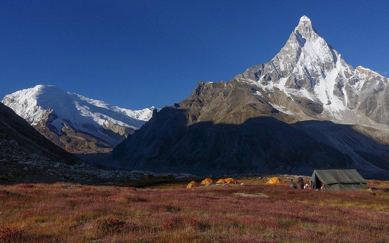
In Sanskrit, Nandanvan means the garden of the gods — the celestial pleasure grove described in ancient texts as the abode of divine beings, a place of perfect beauty existing beyond the ordinary world. Standing at the Nandanvan campsite at 4,380 metres, ringed by the Gangotri massif in one of the most concentrated displays of Himalayan peak architecture accessible to a trekking expedition, the name stops feeling like mythology and starts feeling like accurate description.
The Nandanvan Trek takes you through the heart of the sacred upper Gangotri Valley — past Gaumukh, the ice-mouth of the Gangotri Glacier, across the moraine fields and glacier terrain that separate the inhabited world from the high mountain world, and into a natural amphitheatre of peaks and ice that defines what the words “Himalayan wilderness” are actually meant to convey. This is not a trek with a single summit or a single viewpoint. It is an immersion in a landscape so completely given over to vertical ice and rock and sky that the human scale becomes, for a few days, a secondary consideration.
The Gangotri Nandanvan Trek is one of the most rewarding — and most honest — high altitude treks India offers. Honest because it makes no effort to be easy, and rewarding because what it gives to those who prepare adequately is access to landscapes that the majority of people who love mountains will never enter. For serious trekkers who have been to Bhojbasa and stood at Gaumukh and looked up the glacier and felt the pull of the terrain above — this is where that pull leads.
What makes the best treks in Gangotri category competitive is the concentration of genuinely world-class destinations in a relatively compact geography. Nandanvan earns its place in this company not through a single dramatic feature but through the completeness of what it delivers: glacier approach, remote camping, 360-degree high mountain views, and the specific silence of a place that sits at the edge of the inhabited Himalayan world.
The Name and the Mythology Behind It
Nandanvan — the garden of heaven — carries in its name a theological claim about the quality of the landscape. Ancient Hindu traditions describe the celestial Nandanvan as the most beautiful of the divine gardens, a place of perfect abundance and aesthetic completeness. That the name should be applied to a high-altitude glacier camp in the Gangotri region says something about how the sages and pilgrims who first named these places understood the relationship between the earthly Himalaya and the divine geography described in scripture.
The entire Gangotri glacier trek corridor is understood in Hindu sacred geography as terrain of exceptional spiritual potency. The river that begins here as glacial meltwater — the Bhagirathi, which joins the Alaknanda at Devprayag to become the Ganga — is the most sacred river in India, and the glacier that feeds it carries that significance upstream. Every step deeper into this valley is a step toward what the tradition identifies as the origin point of the sacred.
Nandanvan sits within the zone where ancient texts locate the retreat grounds of rishis who sought the Himalaya’s highest and most remote terrain for their practice. The meadow character of the campsite — flat, open, protected on the windward side by the moraine ridges — creates exactly the sheltered, elevated environment that contemplative traditions have always been drawn to. The sages who came here were not seeking the summit. They were seeking the quality of silence and spatial freedom that this particular location in the high Himalayan basin provides.
For trekkers who approach the route with awareness of this dimension — who understand that the landscape they are moving through has been considered sacred for as long as people have been making records of what they consider sacred — the Nandanvan Trek carries a different weight from a purely athletic expedition. Both dimensions are real. Both are available.
The Visual World of Nandanvan
Himalayan trekking Uttarkashi rarely concentrates its visual rewards as densely as the Nandanvan basin does. The specific combination of features visible from the camp — the Gangotri Glacier in its full upper extension, the Bhagirathi group, Shivling’s unmistakable silhouette, the ice seracs on the hanging glaciers of the surrounding ridgelines — is a panorama that serious mountain photographers actively seek and rarely find in such accessible form.
The glacier terrain itself has a visual grammar distinct from any other landscape. Ice in its various states — compressed blue in crevasse walls, white and fractured at the surface, translucent green where glacial streams cut through shallow sections — produces a colour palette that belongs entirely to itself. The moraine fields, in their layered greys and occasional ochres where iron-bearing rock is exposed, provide a visual counterpoint to the white above that gives the basin’s panorama its tonal depth.
Sunrise at Nandanvan — when the first light catches the high peaks while the campsite below is still in cold shadow — is the expedition’s defining visual experience. The sequence of illumination across the surrounding summits, moving from the highest points downward as the sun climbs, takes perhaps thirty minutes from first light to full morning. Most trekkers spend this time outside the tent, cold and entirely awake, watching it without speaking.
The Broader Landscape: What Surrounds This Trek
Gangotri Temple opens and closes the expedition — its sacred significance deepens through the journey rather than diminishing with familiarity.
Gaumukh Glacier is both a transit point and a destination — the glacier snout, the largest in the Indian subcontinent outside the Karakoram, is worth time beyond what the expedition schedule strictly requires.
Tapovan Trek — the alternative high camp on the glacier’s southern margin, with its extraordinary Shivling views — is the natural companion objective for those building a longer programme in the upper Gangotri valley.
Kedar Tal Trek offers a completely different but equally rewarding adventure tourism Uttarakhand experience north of Gangotri — a high-altitude lake in a different drainage, accessible through forest and cliff terrain rather than glacier, and demanding in its own way.
Harsil Valley and Mukhba Village in the lower Bhagirathi drainage provide the cultural and pastoral complement to the high terrain above — Garhwali village life, apple orchards, the winter home of the Gangotri deity, and the traditional hospitality of mountain communities with deep roots in this landscape.
Why Kashi of North for This Route
KashiOfNorth.com was built on the understanding that the best experiences in Uttarkashi are not the ones that appear first in search results but the ones that require genuine local knowledge to access properly. The Gangotri Nandanvan Trek is precisely this kind of experience — a route with significant technical demands, logistical complexity, and sacred geographic context that reward the traveller who approaches with adequate preparation and the right guide relationships.
Kashi of North provides what the route requires: current conditions intelligence from guides with recent Nandanvan experience, permit guidance, cultural context for the sacred geography the trek moves through, and the authentic local knowledge that separates a genuine Himalayan expedition from a generic adventure package. Glacier treks Uttarakhand of this calibre deserve this standard of support.
Before You Set Out
- Acclimatise without abbreviation. One full day at Gangotri before the first climb is the minimum. Two days is better. The glacier terrain above Gaumukh is unforgiving of altitude-compromised judgment.
- Guides are essential, not optional. The glacier approach to Nandanvan changes from season to season as the glacier retreats and moraine fields shift. A guide with recent first-hand experience of the route is the expedition’s most important safety asset.
- Carry crampons and know how to use them. The glacier crossing above Gaumukh requires ice technique. Arrive with the skill, not the plan to develop it.
- Start each day early. Pre-dawn starts give stable early-morning conditions on the glacier, the best light for photography, and the time buffer that separates a demanding day from a dangerous one.
- Emergency supplies are non-negotiable. Altitude sickness medication (consult your physician about Diamox and dexamethasone protocols before departure), a comprehensive first aid kit, and a satellite communication device for remote terrain are the emergency infrastructure this route requires.
- Zero trace on the glacier. The upper Gangotri basin is a protected zone of extreme ecological sensitivity. All waste comes out. All campsites are left without evidence of occupancy. This is the minimum standard of conduct for this terrain, and it is the standard that keeps the route worth coming to.
Nandanvan earns its name. The garden of heaven the ancient texts describe is not a metaphor when you are standing in the camp at dawn, watching the first light move across Shivling and the Bhagirathi peaks in the cold air of the upper Gangotri basin, with the glacier spreading below and the absolute silence of the high Himalaya all around you. It is a description.
Explore the full spectrum of Himalayan trekking routes and sacred mountain destinations in Uttarkashi at kashiofnorth.com
Highlights
- ✨ Trek from Gangotri to Chirbasa camp (09 km) (3580 Meter)
- ✨ Trek from Chirbasa camp to Bhojbasa camp (5 km) (3775 Meter)
- ✨ Trek from Bhojbasa camp to via Gomukh to Tapovan camp (09 km) (4500 Meter)
- ✨ Exploration Day Nil Tal and Shivling base camp (4619 Meter) back to camp
- ✨ Trek from Tapovan to Nandanvan camp (6 km) (4810 Meter)
- ✨ Nandanvan to Bhojbasa camp (14 km) (3775 Meter)
- ✨ Trek from Bhojbasa camp to Gangotri (14 km) (3415 Meter)