
Gartang Gali is a wooden stairway bolted into a sheer granite cliff above the Jadh Ganga river in Uttarkashi district, Uttarakhand — a structure that once carried traders and pack animals between the upper Bhagirathi valley and Tibet. It was sealed off for nearly six decades after the 1962 war with China, restored using traditional carpentry, and reopened to travelers in 2021. Today it is one of the few places in India where a visitor can walk a real Himalayan trade route on foot, with the Nelong Valley’s high-altitude desert landscape opening up just beyond it.
This guide covers everything a traveler needs before heading there — where it actually sits in relation to Harsil, what is documented about its history versus what is local tradition, the current permit and fee situation, the trek itself, safety and seasonal access, and how to fit it sensibly into a Harsil Valley trip. Kashi of North arranges Gartang Gali and Harsil Valley trips for travelers who’d rather not chase permit paperwork and road-condition updates themselves — more on that toward the end.
Gartang Gali at a Glance
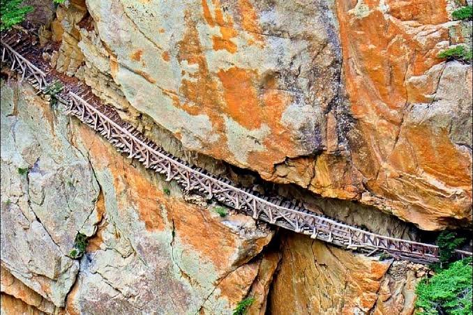
Gartang Gali is a historic wooden stairway fixed into a vertical rock face in Uttarkashi district, Uttarakhand, above the Jadh Ganga river near Bhaironghati. Built as part of an old trade corridor between the upper Bhagirathi valley and Tibet, it was closed for security reasons after the 1962 war and reopened to tourists in 2021 following restoration. It now sits at the edge of the Nelong Valley and is one of Uttarakhand’s more distinctive heritage walks.
| Information | Details |
|---|---|
| Name | Gartang Gali |
| District | Uttarkashi |
| State | Uttarakhand |
| Region | Upper Bhagirathi valley, on the edge of Nelong Valley |
| Type | Wooden stairway built into a cliff face |
| Altitude | Roughly 11,000 ft (approx. 3,350 m) |
| Approx. length | Commonly cited as 136 metres (some sources give differing figures — treat as approximate) |
| Approx. width | 1.8–1.9 metres |
| Main material | Deodar (devdar) wood set into granite, with iron anchoring and a wooden handrail |
| Historical purpose | Trans-Himalayan trade route toward Tibet |
| Closed | 1962–2021, after the Indo-China war |
| Reopened | 2021, following restoration |
| Nearest tourist base | Harsil Valley |
| Located within | Gangotri National Park |
| Best season | April to November (excluding heavy monsoon weeks); typically closed through winter |
| Permit | Required — forest department entry permit (details below) |
| Suitable for | Heritage travelers, moderately fit trekkers, photographers |
Fees, timings and seasonal dates change from year to year — always confirm current status before you travel. Kashi of North checks this before booking your trip.
Where Is Gartang Gali Located?
Gartang Gali sits inside Gangotri National Park, on the Gangotri Highway between Lanka Bridge and Bhaironghati, roughly 90 km by road from Uttarkashi town. It is not inside Harsil village itself — Harsil is the nearest proper settlement and tourist base, and travelers head onward from there, past Dharali and Lanka, to reach the Gartang Gali forest check post. From the check post, the wooden stairway is reached on foot.
Geographically, the sequence runs:
Uttarkashi → Bhatwari → Gangnani → Harsil → Dharali → Lanka Bridge → Bhaironghati → Gartang Gali → Nelong/Jadung Valley
Beyond Gartang Gali, the road and old trade trail continue into Nelong Valley and further toward Jadung — both close to the international border and both under tighter access rules than Gartang Gali itself.
Gartang Gali and Harsil Valley
Because most people search for this place alongside Harsil, it’s worth being precise about the relationship. Harsil is a village and the main tourist hub of the upper Bhagirathi valley — known for its deodar forests, apple orchards, and army cantonment presence. Gartang Gali is a separate site further up the valley, past Dharali and Lanka. Distances quoted for “Harsil to Gartang Gali” vary between sources — figures anywhere from around 15 km to 20 km appear depending on whether they’re measuring to the check post or to the road turn near Lanka — but as a practical guide, budget roughly 45 minutes to just over an hour of driving from Harsil to the trailhead, plus the walk itself.
Because of this proximity, almost every visitor treats Gartang Gali as a half-day excursion from a Harsil base rather than a standalone destination. This also means a Gartang Gali trip pairs naturally with the rest of the Harsil Valley circuit — Dharali, Bagori, Mukhba, and, permit allowing, Nelong Valley.
History of Gartang Gali
The Trade Route
Long before it was a tourist attraction, this stretch of cliff was a working trade artery. Traders — accounts commonly point to Bhotiya trading communities of the upper Bhagirathi region and traders associated with Taknore Patti, alongside later references to Peshawari traders — used this route seasonally to carry wool, salt, sugar, grain, oil, leather and other goods between the Indian side and Tibet, often timed around winter trading gatherings such as the Magh Mela in January. Goods moved on the backs of people, yaks, and sheep along a route where a sheer rock face would otherwise have blocked the way entirely — which is why a stairway had to be cut and built directly into the cliff.
Who Built It, and When
The stairway is widely described in tourism and local accounts as roughly 150 years old, with several sources attributing its construction to Pathan traders from Peshawar who worked the granite face by hand. This is the most commonly repeated account, but it should be read as documented local tradition rather than an archivally verified fact — precise construction records for a structure like this are thin, and readers researching further may find slightly different tellings of who exactly carved it and in which decade. What’s well-corroborated is the age bracket (roughly late 19th century) and its function as a trade corridor until 1962.
Why It Was Built
The terrain here offered no alternative. A vertical granite wall runs directly above the Jadh Ganga, and there was no way to route a path around it without cutting one into the rock itself. The response was practical mountain engineering: wooden steps and platforms bolted into the cliff, narrow enough to follow the rock’s contours, giving traders and animals safe footing across a stretch that would otherwise have been impassable.
The 1962 Closure
Following the Sino-Indian war of 1962, the Indian government sealed this entire frontier stretch — Gartang Gali included — for strategic and security reasons, since it sits close to the international border. The trade that had run through here for generations stopped overnight, and the structure itself was left to decay under snow, rain and neglect for close to 59 years.
Architecture and Structure
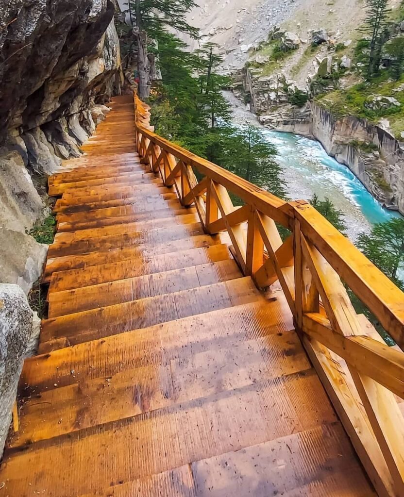
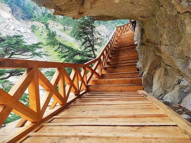
Gartang Gali is best understood as a wooden staircase-cum-walkway anchored directly into a vertical granite face rather than a conventional bridge spanning open ground. The steps and platform are built mainly from deodar wood, secured to the rock with iron fittings, and finished with a wooden handrail along the outer edge. In places the trail narrows enough that the overhanging rock forces visitors to duck slightly to pass through.
How Long Is Gartang Gali?
The figure most frequently cited across guides and government-linked reporting is approximately 136 metres in length and around 1.8 to 1.9 metres wide. A small number of sources describe a longer stretch of walkway (closer to 300 metres), which likely reflects differing definitions of where the “stairway” starts and ends versus the full approach trail — so treat the 136-metre figure as the standard reference point, with some variation possible depending on the source. There’s no consistently documented, verified count of the total number of individual steps, so it’s best not to rely on any specific number you see quoted for that.
Restoration and Reopening
After decades of exposure, the original wooden structure had deteriorated badly by the time restoration work began. The approach taken was to rebuild the walkway using the same traditional method — deodar wood set into the granite with iron anchoring — rather than replacing it with a modern bridge design. It’s worth being precise here: this was a restoration and rebuild of a decayed structure using traditional materials and technique, not a claim that every original wooden plank from the 19th century has survived intact. Gartang Gali reopened to the public in 2021, after being off-limits for 59 years, and has since become a seasonal fixture of the Gangotri National Park visitor circuit, opening each year once winter snow clears and closing again before the next winter sets in.
Is Gartang Gali a Trek?
Not in the multi-day sense of the word. Reaching Gartang Gali involves driving to the forest check post near Lanka Bridge, then walking roughly 2 to 2.5 km uphill through pine, oak and deodar forest to reach the wooden stairway itself. It’s a single, short, out-and-back walk rather than a trek requiring camping gear or overnight stops — commonly completed in a few hours round trip depending on pace and how long you spend at the stairway.
That said, “short” doesn’t mean flat or effortless. The path climbs steadily, sits at high altitude (around 11,000 ft), and the final stretch across the wooden stairway itself is narrow with real exposure below. Reasonably fit adults, including many families with older children, manage it comfortably. Very young children, anyone with a fear of heights or exposed edges, and travelers with mobility limitations should think carefully before attempting the stairway section specifically — the approach trail is fine for most people, but the exposed cliff walkway is not for everyone.
Difficulty Level
| Factor | What to Expect |
|---|---|
| Approach walk | Roughly 2–2.5 km uphill on forest trail; moderate but manageable for most fit adults |
| The stairway itself | Narrow, exposed, fixed to a cliff face — requires steady footing and comfort with heights |
| Altitude | Around 11,000 ft — mild altitude effects possible, especially if not acclimatized |
| Children | Older, supervised children generally manage the walk; the stairway needs adult judgment call |
| Elderly travelers | Assess individually — the uphill walk and stairway both demand reasonable fitness |
| Monsoon (Jul–Aug) | Trail can be slippery; landslide risk on the approach road; not recommended |
| Winter (Nov–Mar) | Typically closed due to snow and safety |
Is Gartang Gali Safe?
Under normal, dry conditions and with the permit and check-post process followed, Gartang Gali is a manageable, well-supervised walk — forest department staff are stationed at the entry point, group sizes on the stairway are controlled, and a handrail runs along the exposed edge. That said, a few real risk factors are worth taking seriously:
- The final stretch is a narrow wooden walkway bolted to a cliff, with a genuine drop below — this is not a place for horseplay, leaning on the rail, or ignoring staff instructions.
- Wet or icy wood is significantly more slippery than dry wood, so monsoon and early-winter visits carry higher risk.
- The approach road runs through landslide-prone mountain terrain, particularly during and after heavy rain.
- Because this is a restricted border-adjacent zone, access can be paused at short notice by local administration for security or weather reasons — this isn’t negotiable and shouldn’t be treated as an inconvenience to argue around.
Conditions here genuinely change season to season and even day to day, so treat any fixed claim about “safe” or “open” as time-sensitive and confirm before you travel.
Opening Dates, Timings and Seasonal Access
Gartang Gali, along with the rest of Gangotri National Park’s trekking routes, follows a seasonal opening — the 2026 season opened on 1 April, and in past years the site has generally stayed closed from around late November through March due to snow and safety concerns. Within the open season, entry generally runs through the daytime, with a typical daily window of roughly 9:00 AM to 4:00 or 5:00 PM and last entry cut off in the mid-afternoon (commonly cited around 3:00–3:30 PM) so everyone can complete the walk and exit before dark. Permits are also not issued during heavy rain or poor visibility, regardless of the calendar date.
These specific hours and season dates are set administratively and do shift slightly year to year, so treat the ranges above as a planning guide rather than a fixed promise — confirm current timings before you travel, which is something Kashi of North does as part of arranging your trip.
Gartang Gali Permit and Fees
Because Gartang Gali sits inside Gangotri National Park and close to the Indo-China border, a forest department entry permit is mandatory — you cannot walk the stairway without one.
How it’s obtained: Permits can typically be arranged in advance online through Uttarakhand’s forest/tourism permit system, or in person at the Uttarkashi forest office, or directly at the check post near Lanka Bridge/Bhaironghati on the day, subject to availability. A valid government photo ID (Aadhaar, PAN, or passport for foreign nationals) is required either way.
Fees: Reported figures vary somewhat between sources and have changed over recent years — Indian nationals are commonly quoted in the range of roughly ₹150–250 per person, and foreign nationals somewhere in the ₹600–850 range. These numbers are set by the forest department and revised periodically, so don’t treat any figure you read (including this one) as guaranteed on the day — confirm the current rate when you book.
Gartang Gali vs Nelong/Jadung Valley — an important distinction: The permit that gets you onto the Gartang Gali stairway is a standard park entry permit. Going further into Nelong Valley or Jadung Valley, which lie deeper inside the restricted border belt, typically requires a separate, more tightly controlled Inner Line Permit (ILP), generally issued through the SDM office in Uttarkashi and, in practice, currently made available mainly to Indian nationals. Don’t assume a Gartang Gali permit automatically covers onward travel into Nelong or Jadung — check specifically if that’s part of your plan.
Permit rules for this border zone can change with little notice. Kashi of North handles the current permit process and paperwork for guests booking a Gartang Gali or Nelong Valley trip, so you’re not left tracking rule changes yourself.
How to Reach Gartang Gali
From Uttarkashi
Gartang Gali is roughly 90 km from Uttarkashi town by road, via Bhatwari, Gangnani and Harsil to reach Bhaironghati and the Lanka Bridge check post. The drive on mountain roads typically takes several hours depending on road conditions — private taxi is the practical option, and Kashi of North arranges this end-to-end.
From Harsil
From Harsil, continue on the Gangotri road past Dharali to Lanka Bridge and the Gartang Gali check post — roughly 15–20 km depending on the exact starting point in Harsil, generally under an hour and a half of driving before the walk itself.
From Dehradun
The broad route is Dehradun → Mussoorie → Chinyalisaur → Dharasu → Uttarkashi → Bhatwari → Gangnani → Harsil → Lanka Bridge → Gartang Gali. This is a long mountain-road journey typically covered over one to two days with an overnight stop, rather than a single-day drive — plan accordingly rather than assuming it can be rushed.
From Rishikesh
From Rishikesh, the route runs via Tehri and Uttarkashi before joining the same Harsil-bound road: Rishikesh → Tehri → Uttarkashi → Harsil region → Gartang Gali.
By Air and Rail
The nearest airport is Jolly Grant Airport in Dehradun; the nearest railhead is in Rishikesh (with Dehradun also well connected). From either, the remaining journey to Uttarkashi and onward to Harsil is by road.
By Taxi
Given the distances and mountain-road driving involved, most travelers book a private taxi for the full circuit rather than relying on shared transport, which is limited on this stretch. Kashi of North arranges private taxis for the Uttarkashi–Harsil–Gartang Gali route, including drivers familiar with the check-post process and current road conditions.
Best Time to Visit
April–June: Generally the most comfortable window — daytime temperatures are pleasant, roads are typically clear after winter closure, and this is peak tourist season for the Harsil–Gangotri belt.
July–August: Monsoon. Rain increases landslide risk on the mountain roads, the wooden stairway gets slippery, and access can be paused without notice. Best avoided unless you have flexible dates.
September–October: Often cited as a strong window for mountain visibility, once the monsoon clears and before winter cold sets in — clearer skies generally mean better views of the surrounding peaks.
November–March: Cold, with snow typically closing the site through the winter months. Don’t plan a Gartang Gali visit in this window without directly confirming current access, since closure is the norm rather than the exception.
Photography at Gartang Gali
The setting does most of the work for photographers — the wooden stairway running along bare granite, the Jadh Ganga gorge below, and the high-altitude, sparsely vegetated character of the Nelong Valley beyond it. Morning light tends to catch the cliff face well before the sun climbs high; some visitors also note that late-morning light reaches further into the gorge itself, giving a different mood than the softer early hours.
A few practical points: professional camera equipment may attract an additional charge inside the park, and drones are not permitted anywhere within Gangotri National Park — don’t plan a drone shot here.
Best Photo Spots
- The check-post approach trail, where the forest frames early views of the valley.
- Wide shots of the stairway from a safe distance along the approach path, showing its scale against the cliff.
- The stairway itself, shot while moving with the flow of foot traffic rather than stopping to pose at the edge.
Never step off the marked walkway, lean over the railing, or linger at the edge for a photo — the drop is real, and forest staff generally require visitors to keep moving across the stairway rather than stopping.
Nearby Places to Visit
Harsil Valley — the region’s main tourist base, known for deodar forests, apple orchards, and the Bhagirathi river running through it. read more…
Dharali — a village just before Harsil on the same road, a common stop or alternate stay base. read more…
Bagori Village — home to a Bhotiya community with a distinct hill-village character and architecture. read more….
Mukhba Village — winter seat of the Goddess Ganga idol (moved here from Gangotri temple during the winter closure), with religious significance tied directly to Gangotri. read more..
Gangotri — one of the Char Dham pilgrimage sites and the symbolic source of the Bhagirathi/Ganga, roughly 10 km from Gartang Gali by most estimates. read more..
Nelong Valley — a high-altitude, sparsely vegetated valley just beyond Gartang Gali, often compared to Ladakh in landscape character; access requires the separate Inner Line Permit described above. read more…
Jadung Valley — further into the restricted frontier zone, historically significant as part of the same old trade network, with its own access rules. read more…
Gangnani — known locally for its hot springs, a common stop on the Uttarkashi–Harsil drive. read more…
Bhatwari — a town along the Uttarkashi–Gangotri highway and a practical waypoint for fuel and supplies. read more….
Suggested Itineraries
One-Day Plan (from a Harsil base)
- Morning: Drive from Harsil to the Lanka Bridge check post, complete permit formalities.
- Late morning: Walk to and across the Gartang Gali stairway.
- Afternoon: Return to Harsil/Dharali.
- Evening: Explore Harsil Valley — riverside walks, local markets, orchards in season.
Two-Day Harsil + Gartang Gali Plan
Day 1: Travel in from Uttarkashi via Gangnani; stop at Harsil and Dharali; visit Mukhba village in the afternoon. Day 2: Morning visit to Gartang Gali; return to Harsil for a relaxed second half of the day exploring the valley and villages.
Three-Day Harsil and Gartang Gali Circuit
Day 1: Uttarkashi → Gangnani → Harsil, settle in, evening at leisure. Day 2: Bagori and Mukhba villages in the morning; Gartang Gali in the afternoon (or reverse the order depending on permit timing). Day 3: Optional extension to Gangotri, or a slower morning in Harsil Valley before heading back.
All of the above adjust depending on road conditions, permit availability and the season — Kashi of North fine-tunes the schedule once your travel dates are confirmed.
Where to Stay
There’s no hotel or homestay directly at the Gartang Gali site — the only lodging in the immediate area is a basic, government-run forest rest house, which has limited rooms and is not set up as a general tourist stay. Because of this, essentially every visitor bases themselves in Harsil, Dharali, or Bagori, roughly 15–20 km away, and visits Gartang Gali as a half-day trip from there.
| Stay Type | Best For | What to Expect |
|---|---|---|
| Hotels (Harsil/Dharali) | Families, comfort-focused travelers | Standard rooms, on-site dining, easier booking |
| Homestays (Harsil/Bagori) | Culture-focused travelers | Local family setting, home-cooked meals |
| Guesthouses | Budget travelers | Simple, functional rooms |
| Seasonal/camp stays | Adventure travelers | Closer-to-nature experience, weather-dependent |
Room rates and availability shift by season, so it’s worth locking in a stay ahead of peak months (April–June and September–October) rather than arriving without a booking. Kashi of North arranges hotel, homestay and guesthouse bookings across Harsil, Dharali and Bagori as part of a Gartang Gali trip package — reach out on WhatsApp or email below rather than trying to book cold on arrival.
Food, Network, ATM and Medical Facilities
Food: Options are concentrated in Harsil and Dharali — simple Garhwali home-style meals, basic dhabas, and whatever your homestay or hotel serves. Right around Gartang Gali itself, there’s essentially nothing — carry water and snacks for the walk.
Mobile network: Coverage is inconsistent through this stretch and can drop out entirely closer to the check post and the border-adjacent zone. Download offline maps before you leave Harsil, and don’t rely on being reachable during the walk.
ATMs and fuel: Stock up on cash and fuel in Uttarkashi or Harsil before heading toward Gartang Gali — ATMs are unreliable to nonexistent past that point, and fuel stops thin out.
Medical facilities: Basic medical support exists in Uttarkashi; options thin out considerably beyond Harsil. Carry any personal medication you need, and flag pre-existing health conditions to your driver/guide before setting out.
What to Carry
Clothing: Layered warm clothing even in summer months (mountain temperatures drop fast), a rain shell, gloves and a cap, with proper thermal wear if visiting in the shoulder or cold season.
Footwear: Closed, comfortable trekking or walking shoes with good grip — the wooden steps can be slippery, and open sandals aren’t suitable.
Electronics: A charged power bank, offline maps downloaded in advance, and your camera — remember the no-drone rule inside the park.
Documents: A government photo ID (mandatory for the permit), any permit confirmation, and hotel/taxi booking confirmations.
Personal essentials: Water, sunscreen, sunglasses, any personal medication, and light snacks for the walk.
Adjust the list for season — winter visits (where access exists at all) need considerably heavier layers than a April–June trip.
Rules and Responsible Tourism
Gartang Gali is a restored heritage structure, not a stage set for photos — the way visitors behave on it directly affects how long it stays walkable. A few things to keep in mind:
- Don’t litter on the trail or the stairway — carry your waste back out.
- Don’t carve names, initials or marks into the wooden structure.
- Don’t remove wood, stone, or any part of the structure as a souvenir.
- Don’t lean over the railing, sit down on the stairway, or linger at the edge to take photos — keep moving with the flow of foot traffic.
- Stay within marked and permitted sections; don’t cross barriers into restricted stretches.
- Ask before photographing local residents in Harsil, Dharali, Bagori or Mukhba.
- Minimize single-use plastic, and support local homestays, guides and eateries where you can.
This is also a genuinely sensitive frontier zone, not just a scenic one — follow forest department and check-post staff instructions without argument, since access rules here exist for real security reasons, not bureaucratic inconvenience.
Is Gartang Gali Worth Visiting?
If you’re drawn to Himalayan history, unusual mountain engineering, frontier geography, or photography with real texture to it, yes — there’s very little else in India quite like walking a 19th-century trade route bolted into a cliff face, with a genuinely restricted valley opening up just beyond it. Paired with a Harsil Valley base, it makes for a strong half-day addition to a longer Gangotri-region trip.
It’s a less natural fit if you have significant mobility limitations, a strong fear of heights or exposed edges, or if your trip is built entirely around Char Dham pilgrimage stops with limited spare time — in that case, Mukhba and Gangotri may serve your itinerary better than adding the extra drive and walk to Gartang Gali.
Gartang Gali vs Other Uttarkashi Attractions
| Attraction | Best For | Time Required | Difficulty |
|---|---|---|---|
| Gartang Gali | Heritage, unusual mountain engineering | Half day | Moderate; exposed sections |
| Harsil Valley | Nature, relaxed base | Half–full day | Easy |
| Gangotri | Pilgrimage | Half–full day | Easy to moderate |
| Mukhba | Culture, religion | Short visit | Easy |
| Nelong Valley | Frontier landscape, Ladakh-like terrain | Full day+ | Moderate; permit-dependent |
| Dayara Bugyal | High-altitude meadow trekking | Multi-day | Moderate |
Plan Your Trip with Kashi of North
Between the mandatory forest permit, the seasonal opening dates, changing road conditions on the way up, and the limited accommodation right around the site, Gartang Gali is a trip that goes far more smoothly with someone handling the logistics ahead of you. Kashi of North puts together Gartang Gali and Harsil Valley trips end to end, including:
- Gartang Gali permit and check-post arrangements
- Private taxi from Uttarkashi, Dehradun or Rishikesh to Harsil and Gartang Gali
- Hotel and homestay bookings in Harsil, Dharali and Bagori
- Local guides for Gartang Gali, Harsil Valley and surrounding villages
- Gangotri and Mukhba visits combined into the same trip
- Fully customized Uttarkashi itineraries, from a single day to a multi-day circuit
Website: kashiofnorth.com WhatsApp / Call: +91 7253079221 Email: kashiofnorth@gmail.com
Frequently Asked Questions
1. What is Gartang Gali? A wooden stairway built into a cliff face above the Jadh Ganga river in Uttarkashi district, once part of a Tibet-facing trade route and now open to visitors after restoration.
2. Where is Gartang Gali located? In Uttarkashi district, Uttarakhand, inside Gangotri National Park, on the road between Lanka Bridge and Bhaironghati, near the Nelong Valley.
3. Is Gartang Gali in Harsil? No — it’s a separate site further up the valley from Harsil village, reached by driving on past Dharali and Lanka.
4. How far is Gartang Gali from Harsil? Roughly 15–20 km by road, depending on the exact starting point; figures vary slightly by source.
5. How far is Gartang Gali from Uttarkashi? Approximately 90 km by road via Bhatwari, Gangnani and Harsil.
6. Why is Gartang Gali famous? For its unusual cliff-face wooden construction, its history as a Tibet trade route, its dramatic setting above the Jadh Ganga gorge, and its long closure and eventual reopening.
7. Who built Gartang Gali? Local and tourism accounts commonly credit Pathan traders from Peshawar with building it roughly 150 years ago, though this is largely oral tradition rather than a fully documented historical record.
8. When was Gartang Gali built? Widely described as around 150 years old, placing construction roughly in the late 19th century — an exact date isn’t reliably documented.
9. Why was Gartang Gali built? To create a passable route across a sheer granite cliff that traders and pack animals needed to cross to reach Tibet, where no natural path existed.
10. How long is Gartang Gali? Most commonly cited as approximately 136 metres long and about 1.8–1.9 metres wide; some sources give differing figures, so treat this as approximate.
11. How many steps does Gartang Gali have? There’s no consistently verified official count — avoid trusting any specific number you see quoted.
12. Is Gartang Gali a trek? Not a multi-day trek — it’s a short, roughly 2–2.5 km uphill walk from the Lanka Bridge check post to the stairway, completed in a few hours round trip.
13. Is Gartang Gali difficult to visit? The approach walk is moderate; the stairway itself is narrow and exposed, which is the main challenge rather than distance or fitness alone.
14. Is Gartang Gali safe? Reasonably safe under normal, dry conditions with the permit process and staff supervision followed — but the exposed stairway, potential slipperiness, and landslide-prone approach road all call for caution.
15. Is Gartang Gali open to tourists? Yes, seasonally — it reopened for the 2026 season on 1 April, but is generally closed through winter months.
16. What is the best time to visit Gartang Gali? April to June and September to October are generally the most favorable windows; monsoon (July–August) and winter (roughly November–March) are best avoided.
17. Can I visit Gartang Gali in winter? Generally no — the site typically closes through winter due to snow and safety concerns; always confirm current status rather than assuming.
18. Can I visit Gartang Gali during monsoon? It’s not recommended — wet, slippery wood and landslide risk on the approach road make this a higher-risk period.
19. Does Gartang Gali require a permit? Yes, a forest department entry permit is mandatory, obtainable online in advance or at the check post with a valid government ID.
20. Do I need a permit for Nelong Valley? Yes — a separate, more restricted Inner Line Permit is generally required for Nelong and Jadung Valley, typically issued through the SDM office in Uttarkashi.
21. What is the Gartang Gali route from Dehradun? Dehradun → Mussoorie → Chinyalisaur → Dharasu → Uttarkashi → Bhatwari → Gangnani → Harsil → Lanka Bridge → Gartang Gali.
22. How do I reach Gartang Gali from Uttarkashi? By road via Bhatwari, Gangnani and Harsil to Bhaironghati and the Lanka Bridge check post, roughly 90 km.
23. How do I reach Gartang Gali from Harsil? By continuing on the Gangotri road past Dharali to Lanka Bridge, roughly 15–20 km.
24. Can I visit Gartang Gali by car? You can drive to the Lanka Bridge check post; from there, the final 2–2.5 km to the stairway is on foot.
25. Is taxi service readily available? Shared transport is limited on this stretch — most travelers book a private taxi in advance rather than relying on availability at the spot.
26. Can Kashi of North arrange a taxi? Yes, Kashi of North arranges private taxis for the full Uttarkashi–Harsil–Gartang Gali route.
27. Where should I stay near Gartang Gali? In Harsil, Dharali or Bagori — there’s no proper tourist accommodation directly at the Gartang Gali site itself.
28. Are hotels available near Gartang Gali? Yes, in Harsil and Dharali; Kashi of North can arrange bookings across a range of budgets.
29. Are homestays available in Harsil? Yes — Harsil and nearby Bagori have homestay options offering a more local, immersive stay.
30. What should I carry for a Gartang Gali visit? Warm layered clothing, sturdy closed footwear, water, snacks, sunscreen, a valid photo ID for the permit, and a power bank, since network coverage is unreliable.
31. Can children visit Gartang Gali? Older, supervised children generally manage the approach walk and stairway fine; use your judgment for very young children given the exposed sections.
32. Can elderly travelers visit Gartang Gali? Assess individually — the uphill approach and narrow, exposed stairway require reasonable fitness and steady footing.
33. Is Gartang Gali suitable for photography? Yes — the cliff-face stairway, gorge views and high-altitude Nelong Valley backdrop offer strong photo opportunities, though drones are not permitted in the park.
34. What are the best photography spots? Wide shots from the approach trail and the stairway itself, taken while moving rather than stopping at exposed edges.
35. What places can I visit near Gartang Gali? Bhaironghati, Gangotri, Harsil Valley, Dharali, Bagori, Mukhba, Nelong Valley, Jadung Valley and Gangnani.
36. How far is Gartang Gali from Gangotri? Approximately 10 km, according to most commonly cited figures.
37. How far is Gartang Gali from Mukhba? Mukhba lies along the same Harsil–Gangotri stretch; treat any specific figure as approximate and confirm current road distance when planning.
38. Can Gartang Gali be combined with Harsil Valley? Yes — this is by far the most common way to visit, with Harsil as the overnight base and Gartang Gali as a half-day trip from there.
39. Can Gartang Gali be included in a Char Dham itinerary? Yes, as an optional add-on for travelers heading to Gangotri who have an extra half day and are comfortable with the walk.
40. Is Nelong Valley near Gartang Gali? Yes — it lies just beyond Gartang Gali, deeper into the restricted border belt, and requires a separate Inner Line Permit.
41. Is Jadung Valley near Gartang Gali? Yes, further along the same historic trade corridor, also within the restricted frontier zone.
42. What is the historical importance of Gartang Gali? It’s a surviving piece of physical infrastructure from the Indo-Tibetan trade era, showing how traders crossed otherwise impassable Himalayan terrain.
43. Was Gartang Gali part of an old trade route? Yes — it connected the upper Bhagirathi valley to Tibet, used for barter trade in wool, salt, grain and other goods until 1962.
44. What materials were used to construct Gartang Gali? Primarily deodar wood, anchored into the granite cliff face with iron fittings, with a wooden handrail along the exposed edge.
45. Has Gartang Gali been restored? Yes — it was restored using traditional wood-and-iron construction methods and reopened to the public in 2021 after 59 years of closure.
46. Why is Gartang Gali important for heritage tourism? It’s a rare example of traditional Himalayan trade-route engineering that visitors can physically walk on, connecting directly to the region’s frontier trading history.
47. Is Gartang Gali suitable for a day trip? Yes — it’s typically visited as a half-day excursion from a Harsil-based stay rather than requiring an overnight stop of its own.
48. What are the current entry fees for Gartang Gali? Commonly cited in the range of roughly ₹150–250 for Indian nationals and ₹600–850 for foreign nationals, though this is periodically revised — confirm the current rate before you travel.
49. Can foreign nationals visit Gartang Gali? Yes, foreign nationals can generally visit Gartang Gali itself with the appropriate permit, though onward travel into Nelong/Jadung Valley currently tends to be more restricted — confirm current eligibility if that’s part of your plan.
50. How can I plan a Gartang Gali tour with Kashi of North? Reach out via kashiofnorth.com, WhatsApp/call +91 7253079221, or email kashiofnorth@gmail.com, and the team will handle permits, transport, stays and the full itinerary around your travel dates.
Conclusion
Gartang Gali is more than a scenic stairway for photographs — it’s a working piece of Himalayan trade history, cut into granite by traders who needed a way through terrain that offered none, sealed off for nearly sixty years by a border conflict, and rebuilt for a generation that now visits it on foot rather than with pack animals and sacks of wool. Combined with Harsil Valley, Dharali, Bagori, Mukhba and, permit allowing, Nelong Valley itself, it forms one of the more substantial heritage circuits in the upper Bhagirathi region — provided the permit, timing and road conditions are handled properly.
Kashi of North plans exactly this kind of trip — Gartang Gali tours, Harsil Valley tours, Gangotri tours, hotel and homestay bookings, taxi arrangements, local guides, village visits, and fully customized Uttarkashi itineraries.
Website: kashiofnorth.com WhatsApp / Call: +91 7253079221 Email: kashiofnorth@gmail.com
Note on accuracy: Distances, fees, timings and permit rules for Gartang Gali are set by local forest and tourism authorities and are revised periodically. The figures in this guide reflect the most consistently reported information available at the time of writing — always confirm current details directly with Kashi of North or the relevant local office before finalizing travel plans.