
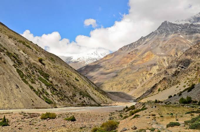
Nelong Valley is a high-altitude cold desert inside Gangotri National Park in Uttarkashi district, Uttarakhand, sitting close to the Indo-Tibetan border at around 3,475 meters. Travelers call it the “Ladakh of Uttarakhand” because the terrain — bare rock in shades of grey and ochre, sparse scrub, a wide windswept valley floor — looks nothing like the green Bhagirathi gorge you drive through to get there. Closed to civilians for 53 years after the 1962 Sino-Indian War, Nelong Valley Uttarakhand reopened for permitted domestic tourism only in 2015, and it remains one of the least-visited, most tightly regulated destinations in the entire Himalaya.
This guide covers the full permit process, the valley’s history, how to reach it, what to expect on the ground, and 27 answered questions — everything you need before you even start the SDM office paperwork in Uttarkashi.
Important note: Nelong Valley sits in an Inner Line Area next to the Indo-Tibet border. Permits, visitor limits, fees, and access rules are set by government and forest authorities and can change without notice. Always verify current requirements with the SDM/DM office in Uttarkashi and the Gangotri National Park Forest Department before traveling. This guide reflects the situation as understood in early 2026.
Where Is Nelong Valley?
Nelong Valley sits inside Gangotri National Park in Uttarkashi district, Uttarakhand, roughly 100 km from Uttarkashi town and 26 km from Harsil, with the last stretch accessible only via Forest Department vehicle from the Bhaironghati checkpoint.
The valley shares its border with Kinnaur district in Himachal Pradesh on one side and Tibet on the other, running broadly east-west along the Jadh Ganga river. There’s a point on the road past Bhaironghati where the world changes completely — the Deodar forest and apple orchards of the Bhagirathi gorge fall away, and you’re suddenly in a cold, silent, wide-open landscape that looks more like the Tibetan plateau than anything else in Uttarakhand.
Planning a Nelong Valley trip? Kashi of North handles the entire permit process so you’re not making three separate office visits in Uttarkashi on your own — WhatsApp +91 7253079221.
Why Is Nelong Valley Famous?
Nelong is famous for looking like nowhere else in Uttarakhand — a genuine cold desert landscape usually associated with Ladakh or Spiti, sitting inside a state otherwise defined by dense forest and green river valleys. Beyond the scenery, it carries real historical weight: the valley was a living Indo-Tibetan trade corridor for centuries, sealed after the 1962 war, and reopened to domestic tourists only in 2015 under strict permit conditions. With a daily visitor cap of roughly 24 people, it stays quieter than almost anywhere else on the Char Dham route.
The valley’s other headline draw is Gartang Gali — a 140-meter wooden pathway carved into a sheer cliff face in the 17th century, restored in 2021, and now one of the most striking heritage structures anywhere in the Himalaya.
History of Nelong Valley
Nelong Valley’s history runs through three phases: centuries as an active Indo-Tibetan trade corridor run by the Jadh Bhotiya community, a sudden and total closure after the 1962 Sino-Indian War, and a slow, carefully controlled reopening for tourism starting in 2015.
The Ancient Trade Corridor
Long before today’s borders existed, the valleys of the Jadh Ganga were commercial arteries linking the Indian subcontinent to the Tibetan Plateau. The Jadh Bhotiya community — also called Rongpas — were the primary traders and residents of Nelong, Jadung, Sumla, Dumka, and neighboring settlements. Wool, salt, borax, and livestock skins came south from Tibet; oil, spices, pulses, jaggery, and grain went north. The annual “Bada Haat” (Big Market) fair held in Uttarkashi town was the trade’s central event — a gathering significant enough that “Badahat” remains part of Uttarkashi’s historical identity today.
Border Disputes Before 1962
The valley’s border position made it a point of dialogue — and occasional dispute — among the Bushahr Kingdom, the Tibetan Empire, and later British India and the Tehri princely state. Records describe a 1914 episode when a Tibetan official attempted to establish a boundary pillar in the valley, which local residents objected to. Discussions between Tehri State and Tibetan authorities over the boundary continued through the 1920s, later folded into wider India-Tibet dialogue before China’s occupation of Tibet. China’s government today claims the area as part of Zanda County in Tibet, a dispute that remains unresolved.
The 1962 War and the Loss of a Homeland
The Sino-Indian War of October 1962 changed everything. Many Nelong and Jadung residents were already at their winter settlements in Bagori and Dunda when the war broke out, and the administration told them they could not return — their ancestral villages had become strategically sensitive border territory overnight. By 1965, the valley was fully evacuated. Roughly 40 families from Nelong and Jadung were resettled permanently in Bagori and Dunda, locations that had previously only been their seasonal winter stops. Houses, granaries, carved wooden doorways — everything was left behind exactly as it was; there was no time or permission to return for belongings.
The valley remained closed to civilians for approximately 53 years, accessible only to the army and border security forces.
Reopening: From Restricted Zone to Border Tourism
In 2015, the government reopened Nelong Valley to domestic tourists under controlled conditions requiring an inner-line permit — part of a broader push to build civilian presence and tourism in sensitive border regions. The 2021 restoration of Gartang Gali added a major heritage attraction. Since then, the government’s Vibrant Villages Programme has targeted the wider Nelong area for infrastructure and tourism development, and discussions about eventually relaxing the permit system have been reported, though as of early 2026 the permit requirement remains firmly in place. Always verify current status before traveling.
Geography and Cold Desert Ecosystem
Nelong Valley’s defining feature is its cold desert ecosystem — high altitude, minimal precipitation, extreme temperature swings, and sparse vegetation — created because the valley sits in the rain shadow of the higher Himalayan ranges.
While the southern slopes of the Garhwal Himalaya soak up heavy monsoon rainfall, Nelong lies far enough north and high enough that monsoon influence is dramatically reduced. Most of what precipitation does fall arrives as snow rather than rain. The result is exposed rock in shades of grey, ochre, and rust, cut through by the Jadh Ganga, with valley walls rising steeply on either side under a sky that looks almost too blue to be real. Surrounding peaks sit in the 5,000–7,000 meter range, with the Bandarpunch Massif and Srikanth visible from the approach road.
The entire valley falls within Gangotri National Park, established in 1982 under the Wild Life Protection Act and covering roughly 1,553 square kilometers — recognized as part of the Western Himalayan Snow Leopard Conservation Landscape.
The Jadh Ganga River
The Jadh Ganga (also written Jaad Ganga) is Nelong’s defining watercourse, rising from glaciers near the Tibet border and flowing west through the valley before meeting the Bhagirathi at Bhaironghati — the confluence that marks the gateway to the restricted zone. Within the valley, smaller streams including Tirpani Gad, Chor Gad, Mana Gad, and Jadhung Gad feed into it along the way. The river carries the classic turquoise-grey color of glacial melt, particularly during the May–June snowmelt period.
Gartang Gali: Engineering in Stone and Wood
Gartang Gali is a 140-meter wooden pathway carved directly into a near-vertical cliff face above the Jadh Ganga gorge, originally built in the 17th century and restored in July 2021 at a cost of roughly ₹64 lakh.
Local accounts credit its construction to Pathan craftsmen from Peshawar, working at the sponsorship of Seth Dhaniram, a merchant of the Nelong Jadh community. It isn’t a bridge in the conventional sense — it’s a ledge cut into and cantilevered from sheer rock, with the river running roughly ninety meters below, originally built to let traders move goods loaded on yaks, horse-mules, and sheep across an otherwise impassable stretch of gorge. It stayed in continuous use until 1962, was used by the army for about a decade after, and then fell into disrepair until its 2021 restoration using Deodar wood.
The restored pathway is 1.8 meters wide, and only 10 visitors are permitted on it at a time, maintaining distance from each other. Jumping, dancing, and carrying inflammable materials on the bridge are prohibited. Some travel accounts connect the route to Austrian mountaineer Heinrich Harrer’s escape toward Tibet during WWII, though this hasn’t been verified through Harrer’s own documented writing.
The Jadh Bhotiya Community
The Jadh are a sub-group of the Bhotiya, classified among the warrior clans of the historic Garhwal Kingdom, and were once rulers of Gartang Garh — one of 52 fortified settlements (garh) in that kingdom. Before 1962, they maintained cultural and marriage ties with Tibetan communities across the border. Their pattern of life was semi-nomadic and seasonal: summers spent in the high villages of Nelong and Jadung, winters in the lower settlements of Bagori and Dunda — a transhumance pattern documented across many high-altitude Himalayan communities.
Today, their descendants live largely in Bagori, near Harsil, where the community’s history is still carried forward through oral memory, craft, and festival traditions like Losar.
Wildlife and Biodiversity
The valley’s decades-long closure to human habitation gave its high-altitude ecosystem an unusual chance to recover, making Nelong one of the better-preserved cold desert habitats in the Indian Himalaya today.
| Species | Status/Notes |
|---|---|
| Snow Leopard (Panthera uncia) | Flagship species, IUCN Vulnerable, extremely rarely sighted |
| Himalayan Blue Sheep (Bharal) | Most commonly seen large mammal, primary Snow Leopard prey |
| Himalayan Tahr | Documented on rocky slopes and cliff faces |
| Himalayan Musk Deer | IUCN Vulnerable, more common in transitional scrub zones |
| Brown Bear | Documented in alpine meadow zones of the park |
| Red Fox | More commonly sighted than large carnivores |
| Himalayan Griffon, Golden Eagle, Lammergeier | Raptors regularly seen soaring on thermals |
| Himalayan Snowcock | Commonly heard, occasionally seen on rocky slopes |
Gangotri National Park has documented 15 mammal species and around 150 bird species overall, and a proposed Snow Leopard Conservation Centre — planned to be India’s first — has been announced for the wider park area, though it remains a proposed rather than operational facility as of early 2026.
A note on expectations: snow leopards are elusive and excellent at concealment. They are not reliably seen on a standard day visit, and any claim of a guaranteed sighting should be treated with skepticism.
Nelong Valley Permit Guide
An Inner Line Permit is mandatory for all Indian nationals visiting Nelong Valley, issued through the SDM/DM office in Uttarkashi, and the process typically takes 1–3 days across multiple office visits; foreign nationals are currently not permitted to enter the restricted zone at all.
Who Can Visit
- Indian citizens: Permitted with a valid Inner Line Permit
- Foreign nationals (including OCI cardholders): Not currently permitted, due to the valley’s border-security designation
Documents Typically Required
- Government-issued photo ID (Aadhaar Card is preferred; Driving Licence commonly accepted)
- Vehicle RC and Driving Licence (if self-driving)
- Multiple photocopies of all documents for every group member
- Passport-size photographs (carry a few, as some offices request them)
The General Permit Process
- Write an application addressed to the SDM/DM of Uttarkashi, listing full names of all visitors, vehicle and driver details, purpose of visit, travel dates, and contact numbers.
- Submit at the District Collectorate in Uttarkashi for verification; you’ll receive a signed acknowledgment letter.
- Police verification at the district Thana/Kotwali in Uttarkashi.
- Forest Department clearance at the DFO office (sometimes called the Kotbangla office) for the National Park entry component.
- Present documentation at Bhaironghati Forest Check Post, pay the park entry fee, and board a Forest Department vehicle for the journey into the valley.
Fees and Limits (Verify Before Travel)
| Item | Approximate Value (2025–26) |
|---|---|
| Gangotri National Park entry fee | ~₹150/person + ₹250/vehicle |
| Daily visitor limit | ~24 persons (6 Forest Dept. vehicles × 4) |
| Permit processing time | 1–3 days |
| Online application available | No — in-person only, as of early 2026 |
Key Rules
- No overnight stay within the 25 km restricted zone from Bhaironghati; all visitors must return by 5:00 PM
- Private vehicles permitted only up to Bhaironghati; beyond that, Forest Department vehicles only
- Two-wheelers are not permitted at any stage of the restricted route
- Drones are strictly prohibited
- Photography of military or security installations is illegal
- Jadung Village requires an additional special permit beyond the standard Nelong permit, granted only in limited cases
Doing the SDM office, police station, and Forest Department rounds yourself can eat up two full days. Kashi of North offers Nelong Valley permit assistance and can often start the process before you even arrive in Uttarkashi — call or WhatsApp +91 7253079221.
How to Reach Nelong Valley
There’s no public transport to Bhaironghati or beyond — all visitors need private or hired transport to that point, then a Forest Department vehicle for the restricted stretch.
| Origin | Distance to Bhaironghati | Driving Time |
|---|---|---|
| Delhi | ~495–534 km | 13–15 hours |
| Dehradun | ~229–245 km | 8–9 hours |
| Haridwar | ~265 km | 8–9 hours |
| Rishikesh | ~250–260 km | 8–9 hours |
| Uttarkashi | ~91–100 km | 3–3.5 hours |
| Harsil | ~18–26 km | 30–60 minutes |
| Gangotri | ~9 km | 20–25 minutes |
By Air: The nearest airport is Jolly Grant Airport (DED), Dehradun, roughly 315–320 km from Nelong Valley. Fly into Delhi if no direct Dehradun connection is available, then continue by road.
By Train: The nearest major railway stations are Rishikesh and Haridwar, both well-connected to Delhi; Dehradun Railway Station is roughly 145 km from Uttarkashi.
By Road: The route runs Rishikesh → Tehri → Chamba → Uttarkashi → Maneri → Bhatwari → Gangnani → Harsil → Bhaironghati, following the Bhagirathi gorge on NH-108. An SUV or 4×4 is strongly recommended, especially for the narrower, cliff-edge sections beyond Uttarkashi.
Not keen on a 13-hour solo drive from Delhi? Kashi of North arranges private taxis and vehicle hire for the full Delhi/Dehradun–Uttarkashi–Harsil–Bhaironghati route.
The Complete Road Journey
Segment 1: Uttarkashi to Harsil (~75–80 km, 2.5–3 hours) — One of the finest mountain drives in the Garhwal Himalaya, following the Bhagirathi through gorge and Deodar forest, passing Gangnani hot springs, Bhatwari, and Dharali. Fill up on fuel in Uttarkashi — there’s no fuel station on this stretch.
Segment 2: Harsil to Bhaironghati (~18–26 km, 30–60 minutes) — Passes Mukhba, Dharali, and Bagori before reaching Bhaironghati, the confluence of the Bhagirathi and Jadh Ganga, and the point where you present permits, pay park fees, and switch to a Forest Department vehicle.
Segment 3: Bhaironghati to Nelong Valley (~23 km, 45–60 minutes by Forest Dept. vehicle) — The road enters the restricted zone, climbing along the Jadh Ganga as vegetation thins from woodland to scrub to open cold desert. Around 4–5 km in, you pass Hawa Bend (known for strong winds) and Pagal Nala (prone to sudden flash floods); at roughly 14 km, Hindoli/Hindola Ghat is a serpentine, zigzagging stretch of road with small waterfalls and glaciers visible nearby. Gartang Gali branches off around 11–14 km from Bhaironghati. The Nelong Village checkpoint, at roughly 23 km and 3,475 m elevation, marks the accessible limit for standard permit holders — beyond it, Jadung Village requires special additional clearance.
Places to Visit Near Nelong Valley
| Place | Distance from Bhaironghati | Time Required | Best Time |
|---|---|---|---|
| Gartang Gali | ~11–14 km (within restricted zone) | 1 hour | May–October |
| Nelong Village Ruins | ~23 km | 1–2 hours | May–October |
| Bhaironghati (confluence) | 0 km | 30–60 minutes | Year-round (May–Nov access) |
| Gangotri Temple | ~9–10 km | Half day | May–June, September–October |
| Harsil | ~18–26 km | 1–3 nights (as base) | Year-round |
| Mukhba Village | ~30 km | Half day | Year-round |
| Bagori Village | ~38–40 km | Half day | Avoid winter (village empties) |
| Dharali | ~35 km | Half day | Check current status |
Bhaironghati — the confluence where the Bhagirathi meets the Jadh Ganga — is worth appreciating in its own right, not just as the permit checkpoint. A small temple dedicated to Bhairon sits at the gorge, and the meeting of two differently colored rivers is a genuinely striking sight.
Bagori carries the most direct human connection to Nelong’s story — this is where the displaced Jadh Bhotiya community was resettled after 1962, and a visit here adds real context to what you’ll see inside the valley.
Want to combine Nelong Valley with Gangotri, Mukhba, and Bagori in one trip? Kashi of North designs multi-stop Uttarkashi itineraries with hotels and transport already arranged.
Things to Do in Nelong Valley
- The scenic drive itself — the landscape transformation from forest to cold desert is the core experience, not just the getting-there
- Walk Gartang Gali — the valley’s signature heritage experience
- Wildlife observation — Bharal on rocky slopes, raptors riding thermals, best in early morning with binoculars
- Explore the Nelong Village ruins with a Forest Department guide, understanding the 1962 displacement
- Bird watching — Himalayan Snowcock, Lammergeier, Golden Eagle, Himalayan Griffon
- Landscape and heritage photography — see the Photography Guide below
Best Time to Visit
May to June and mid-September to mid-October are the two recommended windows for Nelong Valley, offering the clearest roads, most stable weather, and best visibility; the valley is closed entirely from roughly November through April due to snow.
- May–June: Moderate daytime temperatures (roughly 15°C to 2°C), minimal rainfall, low landslide risk, but the Jadh Ganga runs high with snowmelt.
- July–August (monsoon): The cold desert itself can stay relatively clear, but the approach road from Uttarkashi is at high risk of landslides — check road status daily and keep a flexible itinerary.
- Mid-September–mid-October: Widely considered the best window — clear post-monsoon skies, cooler temperatures (roughly 10°C to -5°C daytime range), and peak visibility.
- November onward: The season winds down quickly as snowfall increases; the valley is fully closed by winter.
Month-by-Month Weather Guide
| Month | Day Temp | Night Temp | Road Status | Visitor Rating |
|---|---|---|---|---|
| January | -5°C to 2°C | -15°C to -10°C | Closed | Closed |
| February | -3°C to 5°C | -12°C to -7°C | Closed | Closed |
| March | 2°C to 8°C | -8°C to -3°C | Closed | Closed |
| April | 5°C to 12°C | -5°C to 0°C | Opening (variable) | Permit holders only, late month |
| May | 8°C to 16°C | -2°C to 5°C | Generally open | Good |
| June | 12°C to 20°C | 2°C to 8°C | Open | Good |
| July | 10°C to 18°C | 4°C to 10°C | Check daily | Caution advised |
| August | 10°C to 18°C | 4°C to 10°C | Check daily | Caution advised |
| September | 8°C to 16°C | 0°C to 6°C | Open | Excellent |
| October | 4°C to 12°C | -4°C to 2°C | Open | Excellent |
| November | -2°C to 6°C | -10°C to -4°C | Closing | Early month only |
| December | -8°C to 0°C | -15°C to -8°C | Closed | Closed |
Where to Stay
There’s no accommodation inside the Nelong Valley restricted zone, and overnight stays within 25 km of Bhaironghati are not permitted. Base yourself instead in Harsil, Gangotri, Dharali, or Uttarkashi.
| Location | Distance from Bhaironghati | Notes |
|---|---|---|
| Harsil | ~18–26 km | Best base; widest range of guesthouses and homestays |
| Gangotri | ~9 km | Closer but more basic, pilgrim-oriented |
| Dharali | ~35 km | Quieter, homestay-focused |
| Uttarkashi | ~91–100 km | Best for permit processing days, has ATMs |
Booking a reliable stay for your Nelong Valley base can be tricky without local contacts. Kashi of North handles hotel and homestay bookings across Harsil, Gangotri, and Dharali — WhatsApp +91 7253079221.
Food Guide
There are no food vendors, shops, or dhabas inside the restricted zone — carry everything you need for the day: a packed lunch, high-calorie snacks like nuts and dry fruit, a thermos of hot tea or soup, at least 2 liters of water per person (glacial streams offer additional water, but carry purification tablets), and glucose tablets for altitude energy management.
In Harsil and Gangotri, basic dhabas serve dal-rice, sabzi-roti, parathas, and tea — honest mountain food rather than restaurant dining. Gangotri is strictly vegetarian.
Photography Guide
Nelong’s cold desert palette — ochre, rust, and charcoal rock against a deep blue sky and pale glacial-green river — offers a completely different photography experience from the rest of Uttarakhand.
Landscape: Golden hour light at this altitude creates long, dramatic shadows across the valley floor. Use wide-angle lenses (16–35mm equivalent) to capture the scale of the terrain, and a 70–200mm or longer to compress distant snow peaks.
Gartang Gali: Best photographed from the valley side, looking along the cliff face with the bridge as a thin line against the gorge. Avoid midday, when the contrast between sunlit cliff and shaded gorge is extreme.
Wildlife: A 400mm+ telephoto is genuinely necessary for Bharal, which are often far from the road. Track raptor thermals above the valley walls in early morning.
Legal limits: Never photograph checkpoints, army vehicles, or security installations — this is a legal restriction, and violations can mean equipment confiscation and detention. Drones are absolutely prohibited throughout the restricted zone.
Suggested Itineraries
1 Day (from Harsil base): Depart Harsil 04:30–05:00 → Bhaironghati by 05:30 → permit and Forest Dept. vehicle → Gartang Gali stop → Nelong checkpoint by mid-morning → packed lunch → begin return by early afternoon → back at Bhaironghati and Harsil by evening, respecting the 5:00 PM checkpoint deadline.
2 Days: Day 1 — arrive Harsil, finalize permit if needed, evening at leisure. Day 2 — full Nelong Valley day trip as above.
3 Days: Day 1 — arrive Harsil, visit Bagori village and Lama Top/Sattal in the afternoon. Day 2 — Gartang Gali and Nelong Valley, return to Harsil by evening. Day 3 — add Gangotri Temple before departure.
4 Days (with Gangotri): Day 1 — arrive Harsil. Day 2 — Nelong Valley full day. Day 3 — Gangotri Temple and river photography. Day 4 — return journey.
Want this itinerary built around your exact travel dates? Kashi of North puts together custom Nelong-and-Harsil trip plans with permits, hotels, and transport already sorted — call or WhatsApp +91 7253079221.
Travel Budget
| Category | Estimated Per Person/Day |
|---|---|
| Budget traveler | ₹1,500–₹2,500 |
| Mid-range traveler | ₹2,500–₹4,500 |
| Comfort traveler | ₹4,500–₹8,000+ |
Rough cost components include accommodation (₹400–₹4,000 depending on category), meals (₹300–₹2,000), transport to Bhaironghati, the Gangotri National Park fee (~₹150/person + ₹250/vehicle), and permit-related photocopying and incidental costs (₹200–₹400).
Practical Travel Information
Mobile network: Extremely limited to absent within the restricted zone; BSNL offers the most consistent patchy coverage, Jio and Airtel are unreliable. Don’t depend on connectivity for navigation.
ATMs: None beyond Uttarkashi — withdraw sufficient cash before heading up.
Fuel: Fill up completely in Uttarkashi; there are no fuel stations between Uttarkashi and Bhaironghati.
Medical facilities: None within the valley or at Bhaironghati; the nearest hospital is in Uttarkashi, roughly 3+ hours away. Carry a comprehensive personal first-aid kit.
Altitude: At 3,475–3,824 m, altitude sickness is a genuine risk. Spend at least one night at Harsil (~2,620–2,745 m) before attempting Nelong. Watch for headache, nausea, dizziness, and fatigue, and descend if symptoms worsen — don’t self-medicate with Diamox without medical consultation.
Packing List
- Layered clothing: thermal base, fleece mid-layer, windproof/insulated outer shell
- Sturdy ankle-support hiking shoes
- Warm hat, sun hat, UV-protective sunglasses, gloves
- Sunscreen SPF 50+ and SPF lip balm
- Insulated water bottle and purification tablets
- Original ID documents plus multiple photocopies, including permit copies
- Personal first-aid kit and any prescribed altitude medication
- Extra camera batteries (cold drains them fast)
- Torch/headlamp, whistle, emergency blanket
Emergency Contacts
| Service | Contact |
|---|---|
| Emergency (Police/Fire/Ambulance) | 112 |
| Uttarakhand Tourist Helpline | 1364 |
| SDRF Uttarkashi | 01374-222694 |
| Kashi of North Travel Assistance | +91 7253079221 |
Responsible Tourism
The rules here — no drones, no photographing security installations, no private vehicles beyond Bhaironghati, mandatory return by 5:00 PM — are legal requirements, not suggestions; violations can mean confiscation, detention, or fines. There’s no waste management inside the restricted zone, so carry out everything you carry in — the cold desert ecosystem is extremely sensitive and litter persists for years in these conditions. Stay on the approved road and areas, don’t approach or attempt to attract wildlife, and don’t collect rocks or plants. Visit Bagori village with genuine respect for the community that was displaced from this very valley in 1965, and keep the valley’s silence — it’s not incidental, it’s essential to what makes the place what it is.
Common Mistakes to Avoid
- Arriving in Uttarkashi expecting a same-day permit — plan for 1–3 days
- Not carrying enough cash, since there are no ATMs beyond Uttarkashi
- Underestimating drive times — this is mountain driving, not highway distance
- Bringing a drone, even just in the vehicle, in a restricted border zone
- Arriving without complete documentation and photocopies
- Photographing checkpoints or security installations
- Assuming permit approval is guaranteed — the daily visitor cap can be reached
- Not sharing your travel plan with someone, given limited mobile connectivity
- Ignoring early altitude sickness symptoms
- Rushing the visit — this isn’t a checklist stop; the drive itself deserves time
Conclusion
There aren’t many places in India where you can drive from apple orchards into a genuine cold desert in under two hours — and fewer still where that desert carries the weight of a 17th-century trade route, a displaced community’s history, and sixty years of sealed silence. Nelong Valley is all of that at once: strict rules, a demanding permit process, real cold, and no amenities beyond the checkpoint — and every traveler who makes the effort tends to describe it as unlike anything else in the Himalaya.
Visit with respect for its rules, its history, its community, and its ecology. Take nothing but photographs, leave nothing but footprints.
Ready to plan your Nelong Valley trip? Kashi of North handles the full permit process, hotel and homestay bookings in Harsil and Gangotri, private taxis, local guides, and combined Nelong-Gangotri-Harsil itineraries.
📞 Call/WhatsApp: +91 7253079221 📧 Email: kashiofnorth@gmail.com 🌐 Website: kashiofnorth.com
Frequently Asked Questions
1. What is Nelong Valley? Nelong Valley is a high-altitude cold desert inside Gangotri National Park, Uttarkashi district, Uttarakhand, close to the Indo-Tibetan border. It was a historic trade route with Tibet, closed to civilians after the 1962 war, and reopened for permitted domestic tourism in 2015.
2. Why is Nelong Valley called the “Ladakh of Uttarakhand”? Its cold desert landscape — bare rock, minimal vegetation, arid climate, wide open plateaus — closely resembles Ladakh and Spiti, giving rise to the nickname despite being a geographically distinct region.
3. What is the elevation of Nelong Valley? The Nelong Village checkpoint sits at approximately 3,475 meters (11,400 feet); Jadung Village, further in, is at roughly 3,824 meters (12,547 feet).
4. Do I need a permit to visit Nelong Valley? Yes, an Inner Line Permit issued by the SDM/DM office in Uttarkashi is mandatory, along with the Gangotri National Park entry fee paid at Bhaironghati.
5. Can foreign tourists visit Nelong Valley? No. As of early 2026, Nelong Valley is restricted to Indian nationals only, due to its border-security designation.
6. How many visitors are allowed per day? Approximately 24 people per day (6 Forest Department vehicles × 4 persons) as of 2025–26; this limit is subject to change.
7. Can I drive my own vehicle into Nelong Valley? Only as far as Bhaironghati. Beyond that, only Forest Department vehicles are authorized to enter the restricted zone.
8. Can I stay overnight in Nelong Valley? No. Overnight stays are not permitted within 25 km of Bhaironghati; all visitors must return to the checkpoint by 5:00 PM.
9. Where is the best base for a Nelong Valley visit? Harsil, roughly 18–26 km from Bhaironghati, offers the widest accommodation range and allows a comfortable early departure.
10. What is Gartang Gali? A 140-meter wooden pathway carved into a cliff above the Jadh Ganga gorge, built in the 17th century as part of the Indo-Tibetan trade route, restored in 2021, and now the valley’s headline attraction.
11. How far is Nelong Valley from Uttarkashi? Roughly 91–100 km, about 3–3.5 hours by road to Bhaironghati.
12. How far is Nelong Valley from Delhi? Roughly 495–534 km, about 13–15 hours by road.
13. How far is Nelong Valley from Gangotri? Bhaironghati is about 9 km from Gangotri; the restricted zone extends a further 23 km beyond that.
14. Is Nelong Valley part of Gangotri National Park? Yes, it lies entirely within the park, which covers roughly 1,553 square kilometers.
15. What is the best time to visit Nelong Valley? May–June and mid-September to mid-October are the recommended windows, offering the clearest roads and best visibility.
16. When is Nelong Valley closed? Broadly November through April, when snowfall makes the road impassable.
17. Can I see snow leopards in Nelong Valley? They are documented in the area but rarely sighted on standard day visits — treat any potential sighting as exceptional luck, not an expectation.
18. What wildlife can I see in Nelong Valley? Himalayan Blue Sheep (Bharal) are the most commonly sighted large mammal; Himalayan Griffon and Golden Eagle are regularly seen soaring above the valley, along with Red Fox and various high-altitude birds.
19. Are drones allowed in Nelong Valley? No, drones are strictly prohibited throughout the restricted border area.
20. Can I photograph in Nelong Valley? Landscape and wildlife photography are generally permitted, but photographing checkpoints, army vehicles, or security infrastructure is illegal and carries serious consequences.
21. What documents do I need for the permit? Generally a government-issued photo ID (Aadhaar preferred), vehicle RC and driving licence if self-driving, and multiple photocopies of all documents for every group member.
22. Can I apply for the Nelong Valley permit online? As of early 2026, no — the permit is obtained in person at the Uttarkashi District Collectorate. This may change; verify before travel.
23. How long does the permit take? Typically 1–3 days depending on office availability; allow 3 days to be safe.
24. What is the Gangotri National Park entry fee? Approximately ₹150 per person and ₹250 per vehicle as of 2025–26, paid at the Bhaironghati checkpoint — verify before travel as fees can change.
25. Is there mobile network inside Nelong Valley? Extremely limited; BSNL offers the most consistent patchy coverage, while Jio and Airtel are largely unreliable inside the restricted zone.
26. Are there food or water sources inside Nelong Valley? No shops or restaurants exist within the restricted zone — carry all food and water for the day, though glacial streams offer additional water if purified.
27. Can I visit Jadung Village? Jadung Village, roughly 16 km beyond the Nelong checkpoint, requires an additional special permit beyond the standard Nelong Valley permit, granted only in limited cases.
50 Verified and Well-Supported Facts About Nelong Valley
- Nelong Valley is located within Gangotri National Park, which covers approximately 1,553 square kilometres in Uttarkashi District, Uttarakhand.
- The valley lies close to India’s border with Tibet (the Line of Actual Control) and shares its border with Kinnaur District of Himachal Pradesh.
- The elevation at the Nelong Village checkpoint is approximately 3,475 metres (11,400 feet) above sea level.
- Jadung Village, further into the valley, sits at approximately 3,824 metres (12,547 feet) above sea level.
- The valley was closed to civilian access after the Sino-Indian War of 1962 and remained sealed for approximately 53 years.
- Nelong Valley was reopened to domestic tourists in 2015 under controlled permit conditions.
- Access is restricted to Indian nationals only; foreign nationals are not currently permitted to enter the restricted zone.
- The maximum visitor limit within the restricted zone is approximately 24 persons per day (as of 2025–26), in 6 Forest Department vehicles of 4 persons each.
- Private vehicles are not permitted beyond the Bhaironghati Forest Check Post.
- All visitors must return to the Bhaironghati checkpoint by 5:00 PM.
- Overnight stays within 25 km of Bhaironghati (the restricted zone) are not permitted.
- An Inner Line Permit is required from the SDM/DM office in Uttarkashi; the process typically takes 1–3 days.
- The Gangotri National Park entry fee (approximately ₹150/person + ₹250/vehicle as of 2025–26) is paid at the Bhaironghati checkpoint.
- Drones are strictly prohibited in the Nelong Valley restricted zone.
- Photography of military checkpoints and security infrastructure is prohibited by law.
- The Jadh Ganga (Jaad Ganga) river, a major tributary of the Bhagirathi, flows through the entire length of Nelong Valley.
- The Jadh Ganga meets the Bhagirathi River at Bhaironghati — a dramatic confluence point marking the gateway to the restricted zone.
- Gartang Gali is a 140-metre wooden pathway carved into a cliff face above the Jadh Ganga gorge, originally built in the 17th century.
- The restoration of Gartang Gali was completed in July 2021 at a cost of approximately ₹64 lakh.
- The Gartang Gali pathway is 1.8 metres wide and stands at approximately 11,000 feet above sea level.
- Only 10 visitors are permitted on the Gartang Gali bridge at a time.
- Gartang Gali is attributed to Pathan craftsmen from Peshawar, working at the inspiration of Seth Dhaniram, a merchant of the Nelong Jad community.
- Before 1962, traders loaded goods on yaks, horse-mules, and sheep to cross Gartang Gali on the Indo-Tibetan trade route.
- The army used the Gartang Gali route for approximately ten years after the 1962 war before it fell into disuse and decay.
- The Jadh Bhotiya community are a sub-group of the Bhotiya, classified as a Kshatriya (warrior) clan and historically rulers of Gartang Garh, one of the 52 forts of the Garhwal Kingdom.
- The Jadh Bhotiya community practiced seasonal transhumance — spending summers in Nelong and Jadung, winters in Bagori and Dunda.
- By 1965, all villages in the Nelong Valley were fully evacuated; the Jadh Bhotiya community was resettled in Bagori (summer) and Dunda (winter).
- At the time of evacuation, approximately 40 families lived in the Nelong and Jadung villages combined.
- The ghost villages of Nelong and Jadung remain partially intact — ruins of stone houses, carved wooden doorways, cold stoves, and empty granaries.
- Jadung Village (16 km beyond Nelong Village checkpoint) has approximately 30 abandoned houses.
- The “Bada Haat” (Big Market) held annually in Uttarkashi was the principal commercial event of the Indo-Tibetan trade; Tibetan traders brought wool, salt, and borax; Indian merchants brought spices, pulses, jaggery, and oil.
- The name “Badahat” associated with Uttarkashi is derived from this historic trade fair.
- Some travel accounts link the Gartang Gali route to Austrian mountaineer Heinrich Harrer’s escape to Tibet during WWII, though this has not been verified through Harrer’s own documented accounts.
- The cold desert ecosystem of Nelong is a result of the valley’s position in the rain shadow of higher Himalayan ridges, receiving significantly less precipitation than the valleys to the south and west.
- The Gangotri National Park is recognised as part of the Western Himalayan Snow Leopard Conservation Landscape — a globally significant designation.
- Gangotri National Park has documented 15 mammal species and 150 bird species.
- The Snow Leopard (Panthera uncia) is the flagship species of Gangotri National Park and is documented in the Nelong Valley zone.
- Himalayan Blue Sheep (Bharal, Pseudois nayaur) are the most commonly sighted large mammals in the Nelong Valley area and are documented in peer-reviewed scientific literature (Bhardwaj, Uniyal & Sanyal, 2010, Wildlife Institute of India).
- Himalayan Blue Sheep are the primary prey of the Snow Leopard in this ecosystem.
- Himalayan Tahr (Hemitragus jemlahicus) is documented in Gangotri National Park.
- Himalayan Musk Deer (Moschus chrysogaster) is documented in the park and is listed as Vulnerable on the IUCN Red List.
- The Himalayan Griffon (Gyps himalayensis), Golden Eagle (Aquila chrysaetos), and Lammergeier (Gypaetus barbatus) are documented raptors in the Nelong Valley area.
- The Himalayan Snowcock (Tetraogallus himalayensis) is commonly heard and sometimes seen on the rocky slopes above the valley.
- A proposal for India’s first Snow Leopard Conservation Centre within the Gangotri National Park area has been formally announced.
- The motorable road from Bhaironghati into the valley is maintained by BRO (Border Roads Organisation) under the India-China Border Road Programme.
- The road distance from Bhaironghati to the Nelong Village checkpoint is approximately 23 km.
- “Hindoli Ghat” — approximately 14 km from Bhaironghati — is a zigzag section of the road locally named “Hindola” (swing) for its serpentine character.
- The valley is accessible from approximately May to November; exact open/close dates are determined by the Forest Department each year.
- September and October are consistently identified as the optimal visiting months.
- The Modi government’s Vibrant Villages Programme has included the Nelong Valley area as part of border tourism development, with discussions about permit relaxation ongoing as of 2024–25.
Note: Mobile connectivity within the restricted zone is highly limited. Inform a responsible person of your detailed travel plan and expected return time before entering the restricted zone. In an emergency, the Forest Department vehicle driver and guide who accompany your group are the first point of contact.
For more about the places that make the Harsil Valley and the Gangotri corridor one of the richest travel experiences in India, explore our guides to Gangotri, Gangotri National Park, Gartang Gali, Jadung Valley, Harsil, Mukhba, Dharali, Bagori, Jhala, Bhaironghati, Gaumukh Trek, and the Char Dham Yatra guide. For accommodation near the valley, browse our Hotels in Harsil and Hotels in Gangotri directories, or connect with our recommended Taxi Services for the region.