
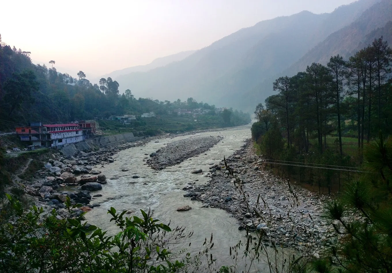
Netala is a small Garhwali village on the Gangotri Highway (NH-34) in Uttarkashi district, Uttarakhand, set in the Bhagirathi Valley on the stretch between the Maneri reservoir and Bhatwari. For most travellers heading toward Gangotri, Netala is a name on a milestone rather than a stop — a cluster of stone-and-timber homes glimpsed through the car window, gone in a minute. It deserves more than that minute. This guide, put together by Kashi Of North, covers everything worth knowing before you visit Netala Uttarkashi — where it is, how to reach it, when to go, what to do once you’re there, and how to plan the rest of your Bhagirathi Valley road trip around it.
Netala won’t overwhelm you with monuments or a ticketed attraction. What it offers instead is a working Himalayan village that hasn’t been rebuilt around tourism — terraced fields, a river that runs cold and fast below the highway, and a pace of life that most people only encounter for the length of a photo stop. Travellers who’ve spent an actual night here — at a village homestay or the small yoga ashram across the Siror bridge — tend to describe it the same way: quieter than they expected, and hard to leave.
Where Is Netala?
Netala sits in the Bhagirathi Valley of Uttarkashi district, on the Gangotri Highway (NH-34), roughly 20–25 km north of Uttarkashi town and about 5–10 km south of Bhatwari. It occupies the section of the valley where the highway leaves the wider, calmer water of the Maneri reservoir behind and re-enters the narrower gorge character that continues, on and off, all the way to Gangotri.
The village sits at an elevation of approximately 1,150 metres, on the banks of the Bhagirathi — the name given to the Ganga in this upper stretch, before it merges with the Alaknanda at Devprayag. A bridge over the river, locally known as the Siror bridge, connects the highway side of Netala to the older residential lanes on the far bank, where most of the traditional stone-and-timber homes stand. It’s a modest crossing, but it’s the clearest landmark that tells you you’ve actually arrived at the village rather than just passed a signboard for it.

Administratively, Netala falls under Uttarkashi district, in the state of Uttarakhand. It has no formal boundary marker or ticketed attraction — it is simply a village the highway happens to run through, which is exactly why it rewards travellers who choose to stop rather than drive past.
Quick Travel Information
| Detail | Information |
|---|---|
| Location | Netala Village, Uttarkashi District, Uttarakhand |
| District | Uttarkashi |
| State | Uttarakhand |
| Elevation | ~1,150 m (3,773 ft) |
| Nearest Town | Uttarkashi (20–25 km) / Bhatwari (5–10 km) |
| Nearest Landmark | Siror bridge over the Bhagirathi River |
| Nearest Airport | Jolly Grant Airport, Dehradun (~165 km) |
| Nearest Railway Station | Rishikesh (~175 km) / Haridwar (~200 km) |
| Best Time to Visit | March–June and September–November |
| Average Temperature | Summer 20°C–32°C / Winter 4°C–15°C |
| Mobile Network | BSNL fairly reliable; Jio and Airtel patchy |
| Internet Availability | Very limited |
| ATM Availability | None at Netala; nearest at Uttarkashi or Bhatwari |
| Fuel Station | Uttarkashi (20–25 km) or Bhatwari (5–10 km) |
| Accommodation | Village homestays and a small ashram stay; wider choice at Bhatwari and Uttarkashi |
| Suitable For | Road trippers, photographers, backpackers, families, pilgrims en route to Gangotri |
| Road Condition | Paved and generally good; monsoon can bring disruptions above Bhatwari |
| Entry Fee | None |
Distances and facilities can shift with the season — always confirm current road and weather conditions before setting out. For real-time updates and help planning around them, Kashi Of North is a WhatsApp message away at +91 7253079221.
Why Visit Netala?
Netala is worth a stop because it is one of the few remaining points on the Gangotri Highway where you can watch ordinary Garhwali village life continue undisturbed a few metres from a major pilgrimage route. In under an hour, you can walk from the highway shoulder into terraced fields, cross a river bridge into a residential lane, and be somewhere that has no interest in being photographed for you.
A working village, not a viewpoint. There’s no ticket counter, no curated walkway, no vendor stalls competing for your attention. What you see — the fields, the animals, the homes — exists because people live and farm here, not because it was arranged for visitors.
The river, up close. The Bhagirathi at Netala runs fast, cold, and startlingly clear in the dry months. It’s glacier-fed, so even a short walk to the water’s edge on a summer afternoon is a genuine sensory jolt — worth doing once, briefly.
A natural pause on a destination-driven route. Most Gangotri Highway itineraries are built around named stops — Gangnani’s hot spring, Harsil’s orchards, the temple at Gangotri itself. Netala doesn’t ask to be on that list. It rewards travellers who are willing to stop without a fixed reason, stretch, and just look at the valley for twenty minutes.
Photography without the crowd. The combination of traditional koti banal architecture, terraced fields, and the specific quality of light in this section of the valley gives photographers compositions that the more visited stops further up the highway, with their parked buses and camera crowds, simply can’t offer.
A quieter overnight option. For travellers who want one night away from hotel corridors and multi-cuisine menus, a homestay or ashram stay at Netala — with home-cooked meals and no signal to distract you — is a different kind of Himalayan night than anything in Uttarkashi or Bhatwari.
History and Heritage of Netala
It’s worth being upfront about what is and isn’t documented. Formal, published historical records specific to Netala are not widely available — like most villages of its size in the Bhagirathi Valley, its history lives in the oral memory and lineage traditions of the families who’ve farmed here for generations, not in written archives.
What can be said with reasonable confidence:
- Netala is a long-established Garhwali agricultural settlement in the mid-Bhagirathi Valley.
- It sits on a corridor that has served pilgrims and traders travelling toward Gangotri for centuries, in some form since long before the modern highway existed.
- The community follows mainstream Garhwali Hindu tradition, including village-specific devta (local deity) worship alongside the wider Hindu festival calendar.
- Its agricultural pattern — terraced fields, mandua and rajma cultivation, small livestock — mirrors the practices of neighbouring valley villages rather than following any documented, distinct history of its own.
The origin of the name “Netala” isn’t recorded in any source we could verify, so this guide won’t speculate on its etymology. Where local residents share oral history or family accounts during a visit, that’s a far more reliable source than anything printed — ask, and listen.
Geography, Climate, Flora and Fauna
Netala sits at the point where the Bhagirathi Valley narrows again after the open water of the Maneri reservoir, entering a gorge character that persists, with occasional widening, most of the way to Gangotri. The valley here is tighter than at Harsil further upstream, but more open than the steep-walled Bhairon Ghati gorge above Bhatwari.
At roughly 1,150 m, the climate is warm-temperate — noticeably milder than Harsil or Gangotri, closer in feel to Bhatwari. Summers (May–June) run 24°C–32°C in the day; winter nights (December–February) can drop to 2°C–5°C, cold enough to need proper layers even though snowfall itself is rare at this elevation.
The hillsides above the village carry lower temperate Himalayan forest — oak and rhododendron dominate, with pine appearing higher up. Along the river, riparian vegetation lines the banks. Langur monkeys are a near-daily sight in the forest canopy above the road. Birdwatchers can look for the Common Merganser and several redstart species along the Bhagirathi, and — much more rarely — Himalayan black bear in the upper forest, generally well away from the highway.
Local Culture and Traditions
The community at Netala observes the standard Garhwali festival calendar — Makar Sankranti, Harela, Phool Dei, Diwali — layered with devta (local deity) festivals specific to individual village lineages. The jagaron tradition, all-night devotional singing dedicated to local deities, remains part of the community’s festival life, typically accompanied by the dhol and damau drums and, on occasion, the curved ransing horn, played by musicians whose role is passed down within specific families.
Phool Dei, the spring flower festival, is one of the more visually striking traditions here — young girls of the village scatter flowers at doorway thresholds as a seasonal blessing, a custom particular to the Garhwal hills with no direct equivalent elsewhere in India.
Architecturally, the older homes at Netala — particularly the ones across the Siror bridge — are built in the koti banal style: alternating bands of stone and deodar cedar timber, a technique developed specifically to withstand earthquakes in a region classified as Seismic Zone V, India’s highest-risk category. Deodar itself is called “devdar” locally — timber of the gods — a name tied to its long use in sacred and residential construction across the Himalaya. Newer construction increasingly follows standard concrete patterns, which makes the surviving koti banal homes worth deliberate attention if traditional architecture interests you.
Agriculture here isn’t a backdrop; it’s the village’s actual economy. Rajma (a smaller, more flavourful local variety of kidney bean), mandua (finger millet, ground into the valley’s staple flatbread), and jhangora (barnyard millet, used in kheer) are the core crops, alongside seasonal vegetables and small livestock. The irrigation channels — kuhls — that feed the terraces are cleared and repaired every spring in a cooperative effort involving most of the village, a piece of maintenance work that’s easy to miss but represents generations of accumulated landscape knowledge.
A Morning in Netala — What the Village Actually Feels Like
Numbers and tables can tell you where Netala is; they can’t tell you what it’s like to actually be there. This section is drawn from travellers who’ve stayed rather than just stopped.
The most useful thing to know going in is how quiet it gets. Phone signal thins out well before you reach the village, and by the time you’re across the Siror bridge, most of the noise of the highway has dropped away too — replaced by the Bhagirathi, which is loud enough at close range that conversation on the riverbank tends to happen at a slight shout. Mornings start early here, mostly because the village does. Walk down to the water before the day heats up and the cold hits you almost as a physical shock — this is glacier melt, and even a few seconds with your hands in it is enough to understand why locals treat the river with respect rather than casual recreation.
Across the bridge, the lanes are narrow and the houses close together, in the way of villages built by families who’ve lived beside each other for generations. Don’t expect anonymity — most people here know their neighbours, their neighbours’ animals, and the walking trails up into the forest better than any map could show you. That familiarity tends to translate into genuine hospitality rather than performance: it’s not unusual to be invited in for tea or a home-cooked meal, and Garhwali hospitality has a habit of extending into good-natured, only-half-joking matchmaking offers for any unmarried member of your group — a very Indian way of making a stranger feel like a guest rather than a tourist.
Higher up the slope, the trail toward the forest is used daily by villagers moving fodder and livestock, and it’s worth watching how surefootedly the pack animals — usually donkeys — manage terrain that would give most visitors pause. It’s a small thing, but it says a lot about how thoroughly this landscape has been worked into daily routine here, rather than treated as scenery.
Practical honesty matters too: if you’re staying at the ashram or in a homestay, don’t expect resort standards. Rooms are simple, dormitory-style in places, and shared with the odd spider or insect that’s made itself at home in the absence of frequent guests — part of what makes it a real village stay rather than a curated one. The nearest proper meal outside your homestay is typically a walk of fifteen to twenty minutes toward Uttarkashi, where a small roadside stop serves apples, chai, and Maggi — reliable, unglamorous, and exactly what you want after a day outdoors.
None of this is dramatic. That’s the point. An evening at Netala, watching the light go from the eastern wall to the western one as the valley cools down, tends to stay with people longer than the “bigger” stops further up the highway.
Things to Do in Netala
Walk the village lanes. This is the core activity at Netala. Cross the Siror bridge and give yourself an unhurried hour or two to walk through the residential lanes, past the koti banal homes, the terraced fields, and the small community shrines. Go slowly; there’s no route to complete, just a place to be in.
Sit by the Bhagirathi. Find a safe spot on the riverbank and spend time near the water — not in it. The current is powerful and glacier-cold even in peak summer, so this is a place for viewing and photography, not swimming.
Photograph the valley and the architecture. The traditional stone-and-timber buildings, the terraced fields (especially vivid at harvest time), and the specific light of this stretch of highway are Netala’s strongest photographic assets. See the Photography Guide below for specifics.
Watch for birds and langurs. Early morning, roughly 6:00–9:00 AM, is the most productive window. Bring binoculars; no guide is strictly necessary, though a local guide adds context.
Talk to people, if invited. Some of the most memorable parts of a Netala visit come from conversations with residents rather than anything you’ll find in a guidebook — always with courtesy, and always asking before photographing anyone.
Have chai, if the stall is open. Not guaranteed, but worth checking. If it’s running, it’s a good excuse to sit for a while and do nothing in particular.
Stay a night. A homestay or the small ashram across the bridge is the single best way to experience Netala properly rather than as a twenty-minute stop. Kashi Of North can help arrange this — see the accommodation section below.
Places to Visit Near Netala
Uttarkashi (20–25 km, 30–40 minutes) — The district headquarters, home to the Kashi Vishwanath Temple, the Manikarnika Ghat, and the Nehru Institute of Mountaineering. The most complete base for services, food, and accommodation in the district. See our Uttarkashi Travel Guide.
Maneri (5–8 km toward Uttarkashi, 10–15 minutes) — The Maneri Bhali reservoir, one of the highway’s most photogenic stops, especially at sunrise. See our Maneri Travel Guide.
Bhatwari (5–10 km, 10–20 minutes) — The nearest service hub, known for its Saturday haat market and the last reliably stocked ATM before the upper valley. See our Bhatwari Travel Guide.
Gangnani (15–20 km, 25–35 minutes) — Home to the Rishi Kund hot spring and the Parashara Rishi Temple. See our Gangnani Travel Guide.
Harsil (45–50 km, 1.5–2 hours) — Apple orchards, a wide river valley, and some of the best-known scenery in the upper Bhagirathi. See our Harsil Travel Guide.
Dharali (close to Harsil, ~48 km) — A riverside village near Harsil known for its own orchards and mountain views. See our Dharali Travel Guide.
Mukhba (near Harsil, seasonal winter seat of Goddess Ganga) — Worth combining with a Harsil visit, particularly in winter. See our Mukhba Travel Guide.
Gangotri (75–80 km, 2.5–3 hours) — The Char Dham temple dedicated to Goddess Ganga, and the reason most people are on this highway in the first place. See our Gangotri Travel Guide.
Nelong Valley (beyond Gangotri, permit required) — A high-altitude valley near the Indo-Tibet border, opened to limited tourism with permits. See our Nelong Valley Guide.
Dayara Bugyal (via Bhatwari, ~30 km plus trek) — One of Uttarakhand’s best-known high-altitude meadows. See our Dayara Bugyal Guide.
Dodital (via Sangam Chatti near Uttarkashi, multi-day trek) — A forest-set alpine lake associated with the birth of Lord Ganesha. See our Dodital Trek Guide.
Distance Guide
| From | Distance to Netala | Approx. Drive Time |
|---|---|---|
| Delhi | 370–380 km | 10–11 hours |
| Dehradun | 150–160 km | 4.5–5.5 hours |
| Haridwar | 190–200 km | 5.5–6.5 hours |
| Rishikesh | 170–180 km | 5–6 hours |
| Uttarkashi | 20–25 km | 30–40 minutes |
| Maneri | 5–8 km | 10–15 minutes |
| Bhatwari | 5–10 km | 10–20 minutes |
| Gangnani | 15–20 km | 25–35 minutes |
| Harsil | 45–50 km | 1.5–2 hours |
| Gangotri | 75–80 km | 2.5–3 hours |
Kilometre figures for Netala vary slightly by source since the village is spread along the highway rather than centred on a single point. Treat these as planning estimates and confirm current conditions before you drive — Kashi Of North can advise on real-time road status.
Best Time to Visit Netala
Spring (March–April) — Rhododendron season. The hillsides above the valley bloom crimson, the weather is mild, and agricultural preparation gives the village an active, unhurried energy. A strong month for photography.
Summer (May–June) — Warm in the valley (24°C–32°C) but pleasant near the river. This is peak Gangotri pilgrimage season, so the highway carries heavier traffic — which makes Netala’s relative quiet more noticeable by contrast.
Monsoon (July–August) — Heavy rain, an intensely green valley, and a real risk of landslide-related disruption on the highway above Bhatwari. Only recommended for travellers comfortable with weather uncertainty and flexible plans.
Autumn (September–November) — Widely considered the best season. Post-monsoon skies clear, the harvest is underway in the terraced fields, and the light across the valley is at its sharpest. October, in particular, is hard to beat.
Winter (December–February) — Cold (nights 2°C–5°C) but accessible, with the lightest tourist presence of the year. Good for travellers who specifically want the valley without any crowd at all.
Month-by-Month Weather Guide
| Month | Day Temp | Night Temp | Conditions | Road Conditions | Recommended? |
|---|---|---|---|---|---|
| January | 10°C–15°C | 2°C–7°C | Cool, clear | Good | Yes — quiet |
| February | 12°C–18°C | 4°C–9°C | Warming, rhododendron buds | Good | Yes |
| March | 17°C–24°C | 8°C–13°C | Rhododendron blooming | Good | Excellent |
| April | 20°C–27°C | 12°C–17°C | Spring warmth | Good | Yes |
| May | 24°C–32°C | 16°C–21°C | Hot, full season | Good | Yes |
| June | 23°C–30°C | 17°C–22°C | Pre-monsoon cloud | Good | Yes |
| July | 21°C–26°C | 17°C–21°C | Monsoon, rain | Disruptions possible | Caution |
| August | 20°C–25°C | 16°C–21°C | Monsoon continuing | Disruptions possible | Caution |
| September | 17°C–23°C | 12°C–17°C | Post-monsoon clearing | Good | Good |
| October | 13°C–20°C | 6°C–12°C | Excellent, harvest | Good | Best month |
| November | 9°C–16°C | 3°C–8°C | Cool, clear, quiet | Good | Yes |
| December | 8°C–14°C | 1°C–6°C | Cold, very quiet | Good | Yes — quiet |
How to Reach Netala
Netala sits directly on the Gangotri Highway (NH-34), so every vehicle travelling between Uttarkashi and Gangotri passes through it — the main decision is simply where you’re starting from.
By Road (Self-Drive)
The most practical option for flexibility. From Uttarkashi, follow the Gangotri Highway north; Netala appears after the Maneri reservoir stretch and before Bhatwari. The road through this section is paved and generally in good condition, though monsoon months (July–August) can bring landslide-related disruption further up, above Bhatwari. Roadside parking at Netala is limited — park well clear of the carriageway.
By Taxi
Private taxis from Uttarkashi, Dehradun, Haridwar, or Rishikesh can be arranged for a direct drop or as part of a longer Gangotri circuit. Kashi Of North arranges taxi services across Uttarkashi district, including custom stops at less-visited points like Netala that standard package itineraries tend to skip.
By Shared Jeep / Bus
From Uttarkashi, shared jeeps and local buses running toward Bhatwari and Gangotri pass through Netala — simply ask the driver to stop. This is the most budget-friendly way to reach the village if you don’t have your own vehicle.
By Train
The nearest railway stations are Rishikesh (~175 km) and Haridwar (~200 km), both well connected to major Indian cities. From either station, continue by road via Dehradun and Uttarkashi.
By Air
The nearest airport is Jolly Grant Airport, Dehradun (~165 km), with regular connections to Delhi and other major cities. From Dehradun, it’s roughly a 5-hour drive to Netala via Uttarkashi.
Where to Stay — Hotels and Homestays
There’s no dedicated hotel or guesthouse within Netala itself, which is part of what keeps it from feeling built up. Two realistic options exist for staying close to or in the village:
Village homestays — Some families in Netala host guests informally; availability isn’t fixed and changes with the season and the household. This is the most immersive way to experience the village, with home-cooked meals and direct contact with daily village life.
Ashram stay — A small yoga ashram operates across the Siror bridge and has hosted retreat groups, offering simple dormitory-style rooms and sattvic vegetarian meals. It’s a basic, no-frills stay rather than a resort experience — worth it specifically for travellers who want a quiet, low-distraction night near the river.
For either option, arrangements typically need to be made in advance rather than on arrival. Kashi Of North can help identify and book current homestay or ashram availability at Netala, and will also suggest nearby alternatives if nothing is available on your travel dates.
If you’d rather stay somewhere with more infrastructure, both nearby towns offer a fuller range of choices:
| Location | Distance from Netala | Options |
|---|---|---|
| Bhatwari | 5–10 km | Basic guesthouses to mid-range hotels |
| Uttarkashi | 20–25 km | Widest range — budget guesthouses through better hotels |
Rates and availability shift seasonally, especially during peak Char Dham months (May–June) and the autumn window (September–October). For current pricing and to lock in a room ahead of your trip, reach out to Kashi Of North on WhatsApp at +91 7253079221 or email kashiofnorth@gmail.com.
Food and Local Cuisine
Netala itself has no established restaurant. Seasonal tea stalls may operate along the highway during the busier months, but this isn’t guaranteed — carry your own water and snacks, and plan your main meals around Bhatwari or Uttarkashi, both a short drive away. The nearest reliable food stop on foot is roughly fifteen to twenty minutes toward Uttarkashi, a simple roadside spot serving apples, chai, and Maggi.
If you’re staying at a homestay or the ashram, meals are typically home-cooked and included as part of the stay — often the best food you’ll have on the whole trip.
Garhwali dishes worth looking for at dhabas in Bhatwari or Uttarkashi:
- Rajma Chawal — the valley’s signature dish, made with the smaller, more flavourful local kidney bean variety
- Aloo ke Gutke — dry-fried potatoes tempered with jakhiya seeds and chilli
- Mandua ki Roti — flatbread made from finger millet, the traditional Garhwali staple grain
- Kafuli — a leafy green curry flavoured with garlic, distinct to the hill kitchens of this region
Photography Guide
Valley and highway compositions. The Gangotri Highway curving along the valley wall, with forested slopes above and the river gorge below, makes for a classic mountain-road frame. Look for slightly elevated points on the road to use the curve as a leading line.
Traditional architecture in context. The koti banal homes across the Siror bridge photograph best when shown as part of the living village rather than isolated — include the fields, the lanes, the mountain backdrop.
Terraced fields. Particularly rewarding at harvest time in October, when the terraces are visually at their most dynamic and colour-rich.
River photography. A polarising filter helps cut glare off the fast-moving Bhagirathi. Shoot with the sun behind you for colour in the water, and experiment with shutter speed — anywhere from 1/500s to freeze the current, to several seconds for a smoothed, silky effect on a tripod.
Sunrise and sunset. The eastern wall of the valley catches first light in the morning; the western slopes hold the last of the afternoon sun. Netala’s specific orientation gives angles that differ from both Maneri (downstream) and Harsil (upstream).
Photographing people. Always ask before photographing anyone in the village — a straightforward, polite request, and a graciously accepted “no” if that’s the answer. The unposed moments of daily life are the most valuable images you can come away with, and also the ones that most require this courtesy.
Drones. Standard DGCA regulations apply across India; there’s no special restriction specific to Netala, but confirm current rules before flying, and always ask locally before doing so near homes.
Wildlife and Nature
The forest above Netala and the river margin below support a reasonable range of wildlife for a roadside location. Langur monkeys are the most reliably visible, usually in the canopy above the highway. Along the Bhagirathi, watch for the Common Merganser (a diving duck that specifically favours fast mountain rivers) and several redstart species. Himalayan black bear is present in the upper forest but very rarely encountered from the road. Early morning, roughly 6:00–9:00 AM, is the best window for birdwatching; bring binoculars.
The forest itself is oak and rhododendron at lower elevations, giving way to pine higher up — all within Uttarkashi Forest Division’s protected jurisdiction, which limits extraction and development in the area.
Suggested Itineraries
Half-Day Stop
- Pull off safely near Netala and park clear of the highway
- Walk the main village lane, 30–45 minutes
- Visit the Bhagirathi riverbank, 15 minutes
- Photography, 30 minutes
- Chai if the stall is open, then continue toward your next stop
Full Day (Netala Plus the Highway Corridor)
- 8:00 AM — Depart Uttarkashi
- 8:30 AM — Sunrise at the Maneri reservoir
- 10:30 AM — Arrive Netala; village walk and photography
- 12:30 PM — Drive to Bhatwari for lunch
- 2:00 PM — Explore Bhatwari market or village
- 4:00 PM — Return to Netala for afternoon light
- 6:00 PM — Back to Uttarkashi
Overnight Stay
- Arrive Netala by late afternoon; settle into a homestay or the ashram
- Evening riverside walk as the light changes
- Home-cooked dinner
- Early morning river walk before departure
Weekend Tour from Delhi
- Day 1 — Delhi to Uttarkashi; evening at the Kashi Vishwanath Temple and Manikarnika Ghat
- Day 2 — Early drive to Maneri for sunrise, then Netala for the village and river, then Bhatwari (time it for Saturday if you want the haat market), then Gangnani’s hot spring before heading back
Photography Tour (2 Days)
- Day 1 — Arrive Uttarkashi; afternoon temple and ghat photography
- Day 2 — Pre-dawn drive to Maneri for sunrise; Netala by 8:00 AM for the village, valley, and river in full morning light; continue to Bhatwari for market photography in the afternoon
Family Visit
- Short drive from Uttarkashi (20–25 minutes)
- Easy-paced village walk
- Safe riverside viewpoint, children closely supervised
- Chai if available, then on to Bhatwari or back to Uttarkashi for lunch
For any of these, Kashi Of North can build a version tailored to your dates, group size, and pace — including taxi, guide, and homestay arrangements in one plan.
Travel Budget
Budget Traveller
| Item | Estimated Cost (INR) |
|---|---|
| Shared jeep (Uttarkashi–Netala–Bhatwari) | ₹100–₹200 |
| Tea and provisions | ₹50–₹150 |
| Budget guesthouse in Bhatwari (if overnight) | ₹400–₹700 |
| Day trip total | ₹150–₹350 |
| Overnight total | ₹550–₹1,050 |
Mid-Range Traveller
| Item | Estimated Cost (INR) |
|---|---|
| Private taxi (Uttarkashi–Netala–Bhatwari circuit) | ₹1,500–₹2,500 |
| Mid-range stay in Bhatwari or Uttarkashi | ₹900–₹2,000 |
| Food at dhabas | ₹400–₹700 |
| Total | ₹2,800–₹5,200 |
Comfort Traveller
| Item | Estimated Cost (INR) |
|---|---|
| Private vehicle from Delhi (return) | ₹14,000–₹20,000 |
| Best available accommodation, 1–2 nights | ₹3,000–₹8,000 |
| Private guide for valley photography | ₹2,000–₹3,500 |
| Total | ₹19,000–₹31,500 |
Prices fluctuate with season and demand — treat these as planning ranges. For a firm quote based on your actual dates, contact Kashi Of North.
Responsible Tourism
Respect the community. Netala is a farming village, not a tourist attraction — approach it as a guest in someone’s home community. Ask before photographing people, don’t enter private land uninvited, and keep noise levels conversational.
Dress appropriately. Full-length clothing covering shoulders and knees is appropriate here, and important if you visit any local shrine.
Carry out everything you carry in. There’s no waste disposal infrastructure at Netala. This is a firm requirement, not a suggestion.
Support the local economy. If a tea stall is open, buy from it rather than relying only on your own supplies. If village families are selling produce, especially rajma during harvest season, buying from them directly puts money straight into the local economy.
Camp responsibly if you camp at all. Get landowner permission first, camp well away from water sources, use a cat hole at least 50 metres from any water for waste, fully extinguish fires, and leave the site exactly as you found it. There is no designated camping infrastructure at Netala.
Practical Information and Emergency Contacts
Mobile network: BSNL is the most consistent carrier here; Jio and Airtel coverage is patchy. Internet access is very limited — plan for a low-connectivity day.
ATM and cash: No ATM at Netala. Withdraw cash at Uttarkashi (most reliable) or Bhatwari before arriving.
Fuel: Fill up at Uttarkashi or Bhatwari; there is no fuel station at Netala.
Medical facilities: None at Netala. The District Hospital in Uttarkashi (20–25 km) is the nearest significant facility; Bhatwari’s CHC (5–10 km) handles basic primary care.
| Service | Contact |
|---|---|
| National Emergency | 112 |
| Police (Uttarkashi/Bhatwari) | 01374-222100 / 01374-255001 |
| District Hospital, Uttarkashi | 01374-222026 |
| SDRF Uttarkashi | 01374-222755 |
| Uttarakhand Tourist Helpline | 1364 |
| Forest Department, Uttarkashi | 01374-222624 |
For travel planning, bookings, or on-ground assistance (not emergencies): Kashi Of North — WhatsApp/Call: +91 7253079221 — Email: kashiofnorth@gmail.com — Website: https://kashiofnorth.com
Common Mistakes Visitors Make
- Not stopping at all. By far the most common mistake — Netala simply isn’t on most itineraries and passes unseen through the window.
- Stopping only at the roadside. The real value is across the Siror bridge, in the village lanes — a five-minute walk that changes the whole experience.
- Travelling without provisions. No guaranteed food or water at Netala; carry both from Bhatwari or Uttarkashi.
- Not carrying cash. There’s no ATM here.
- Photographing people without asking. This causes real friction in a conservative village setting — always ask first.
- Leaving waste behind. There’s no infrastructure to manage it; carry everything out.
- Treating the village as an attraction rather than a community. A respectful mindset changes the whole visit.
- Ignoring monsoon road conditions. July–August can bring landslide disruption above Bhatwari — check before you go.
- Assuming the tea stall will be open. It might not be. Bring your own supplies as backup.
- Skipping the wider context. Netala works best as part of a Maneri–Bhatwari–Gangnani–Harsil–Gangotri road trip, not as an isolated stop.
Planning to Visit Netala?
Kashi Of North can help with every part of your Bhagirathi Valley trip:
- Homestay and ashram bookings at Netala
- Hotel bookings in Bhatwari and Uttarkashi
- Taxi and self-drive route planning
- Gangotri tour packages
- Trek packages for Dayara Bugyal and Dodital
- Local guides for photography and village visits
- Fully customized Uttarkashi district itineraries
📞 WhatsApp / Call: +91 7253079221 📧 Email: kashiofnorth@gmail.com 🌐 Website: https://kashiofnorth.com
Frequently Asked Questions
1. What is Netala Village? Netala is a traditional Garhwali village on the Gangotri Highway (NH-34) in Uttarkashi district, Uttarakhand, roughly 20–25 km from Uttarkashi town, between the Maneri reservoir and Bhatwari.
2. How far is Netala from Uttarkashi? Approximately 20–25 km, about a 30–40 minute drive.
3. What is the best time to visit Netala? September–October for post-monsoon clarity, harvest season, and the finest light. March–April for rhododendron blooms.
4. Is there accommodation at Netala? No dedicated hotels, but village homestays and a small ashram stay are available with advance arrangement. Kashi Of North can help book either. Most visitors otherwise stay in Bhatwari or Uttarkashi.
5. Is food available at Netala? No established restaurant. A basic roadside stop (apples, chai, Maggi) is about 15–20 minutes’ walk toward Uttarkashi. Homestay and ashram stays include home-cooked meals.
6. What is the elevation of Netala? Approximately 1,150 metres (3,773 feet) above sea level.
7. Is Netala directly on the Gangotri Highway? Yes — it sits on NH-34 between Maneri and Bhatwari.
8. What can I do at Netala? Village walks, riverside time at the Bhagirathi, photography of traditional koti banal architecture, birdwatching, and — if arranged — an overnight homestay or ashram stay.
9. How do I reach Netala from Delhi? Via Haridwar, Rishikesh, Devprayag, and Uttarkashi — roughly 370–380 km, about 10–11 hours’ drive.
10. Is Netala suitable for families? Yes — the terrain is manageable and it’s close to Bhatwari and Uttarkashi. Keep children closely supervised near the river, which runs fast and cold.
11. Is there an ATM at Netala? No. The nearest reliable ATM is in Uttarkashi (20–25 km); Bhatwari may have one depending on the day.
12. What crops are grown around Netala? Rajma (local kidney beans), mandua (finger millet), jhangora (barnyard millet), and seasonal vegetables on the terraced fields.
13. Can I access the Bhagirathi River at Netala? Yes, at several points near the village — but the water is fast, cold, and unsuitable for swimming. Viewing and photography only.
14. Is Netala good for photography? Yes — traditional architecture, terraced fields, and a distinctive quality of valley light make it worthwhile, especially with far fewer visitors than the more famous highway stops.
15. What language is spoken in Netala? Garhwali is the community’s everyday language; Hindi is widely understood. English is very limited.
16. Are drones allowed at Netala? Standard DGCA regulations apply; there’s no special restriction here, but confirm current rules and ask locally before flying near homes.
17. What wildlife might I see near Netala? Langur monkeys, various forest and river birds (including the Common Merganser and redstarts), and — rarely — Himalayan black bear in the upper forest.
18. Is camping possible at Netala? Informal camping may be possible with landowner permission; there’s no designated camping infrastructure. Practice leave-no-trace principles fully.
19. Is there mobile network at Netala? BSNL is the most reliable option; Jio and Airtel coverage is inconsistent. Internet is very limited.
20. What is koti banal construction? A traditional Garhwali building technique using alternating bands of stone and deodar cedar, developed for earthquake resistance — visible in Netala’s older homes across the Siror bridge.
21. Is Netala on the Char Dham Yatra route? It’s on the highway leading to Gangotri, the second of the four Char Dham temples.
22. What’s the best month for photography at Netala? October, for clear skies, harvest-season fields, and the sharpest light. March–April is strong too, for rhododendron blooms.
23. How does Netala compare to Bhatwari and Maneri? Maneri has the reservoir landscape; Bhatwari has services and the Saturday market. Netala has neither, but offers the most undeveloped, authentic village character of the three.
24. Is there a temple at Netala? Village shrines serving the community exist, but they aren’t documented pilgrimage sites — they’re active local worship spaces, not visitor attractions.
25. How long should I spend at Netala? A minimum of 30–45 minutes for a village walk; 2–3 hours for a fuller visit including the riverbank and photography. An overnight homestay or ashram stay is the most complete way to experience it.
26. Can I buy local produce at Netala? During harvest season, rajma and other produce may be available directly from village families — the most authentic purchase you can make here.
27. Is fuel available at Netala? No. Fill up at Bhatwari (5–10 km) or Uttarkashi (20–25 km) beforehand.
28. What is Phool Dei? A Garhwali spring festival in which young girls scatter flowers at village doorway thresholds — observed at Netala and across the wider Garhwal hills.
29. Is Netala safe for solo female travellers? Standard precautions for a conservative rural setting apply — dress modestly, travel by daylight, and take advantage of how close Bhatwari and Uttarkashi are if you need more developed facilities.
30. What makes Netala different from other highway villages? Its combination of genuine, undeveloped village life, a distinctive position in the valley between Maneri’s reservoir and Bhatwari’s services, and easy accessibility right off the highway.
31. Can I see rhododendrons at Netala? Yes — the hillsides above the village bloom crimson with Rhododendron arboreum in March–April.
32. What birds are common at Netala? Along the river: Common Merganser, plumbeous and white-capped redstarts, and occasionally forktails. In the forest: various babblers, thrushes, and woodpeckers.
33. Is Netala’s history documented anywhere? Not in detail — published historical records specific to the village are limited. Its history lives mainly in local oral tradition.
34. Is the road through Netala in good condition? Generally yes — paved and well-maintained. Monsoon months can bring disruptions further up the highway, above Bhatwari.
35. How does Netala fit into a longer Uttarkashi trip? Best treated as a stop between Uttarkashi (or Maneri) and Bhatwari–Gangnani–Harsil–Gangotri — adding an authentic village dimension to a route that can otherwise be all about driving through to the famous destinations. Kashi Of North can help build this into a full itinerary around your dates.
Explore More of Uttarkashi District
- Uttarkashi Travel Guide
- Maneri Travel Guide
- Bhatwari Travel Guide
- Gangnani Travel Guide
- Harsil Travel Guide
- Dharali Travel Guide
- Mukhba Travel Guide
- Gangotri Travel Guide
- Nelong Valley Guide
- Dayara Bugyal Guide
- Dodital Trek Guide
- Char Dham Yatra Guide
- Hotels in Uttarkashi District
- Taxi Services in Uttarkashi
Conclusion
Netala Uttarkashi isn’t a destination that announces itself. It has no ticketed monument, no scheduled aarti, and no guarantee that the tea stall will be open when you arrive. What it offers instead is a genuine cross-section of Garhwali village life on the Bhagirathi Valley’s mid-stretch — terraced fields worked by the families who’ve always worked them, a koti banal architecture that’s increasingly rare across the region, and a river cold and fast enough to remind you exactly where its water comes from.
For travellers moving through Uttarkashi district toward Gangotri, Netala is worth the twenty minutes it takes to stop, and worth a full night if you can spare it. It sits between the more famous points on the highway — Maneri’s reservoir, Bhatwari’s market, Harsil’s orchards, Gangotri’s temple — and sometimes, that in-between is exactly the point.
Ready to plan your visit? Kashi Of North can arrange homestays, ashram stays, taxis, guides, and a full custom itinerary around Netala and the rest of the Bhagirathi Valley.
📞 WhatsApp / Call: +91 7253079221 📧 Email: kashiofnorth@gmail.com 🌐 Website: https://kashiofnorth.com